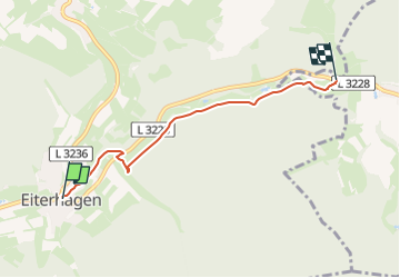
![](/images/other/stat-length.png)
![Excursión A pie Söhrewald - Grimmsteig Zubringer Eiterhagen-Grundmühle - Photo](https://media.geolcdn.com/t/1900/400/9f08d20f-1906-4db5-8ba1-892c48a34a8b.jpeg&format=pjpeg&maxdim=2)
Grimmsteig Zubringer Eiterhagen-Grundmühle
SityTrail - itinéraires balisés pédestres
Tous les sentiers balisés d’Europe GUIDE+
![Longitud](/images/other/stat-length.png)
![Altitud máxima](https://static1.geolcdn.com/siteimages/upload/files/1508320355ic_sort_altitude_max_24dp.png)
![Desnivel positivo](https://static1.geolcdn.com/siteimages/upload/files/1508320355ic_sort_den_pos_24dp.png)
![Km-Effort](/images/other/stat-length.png)
![Altitud mínima](https://static1.geolcdn.com/siteimages/upload/files/1508320355ic_sort_altitude_min_24dp.png)
![Desnivel negativo](https://static1.geolcdn.com/siteimages/upload/files/1508320355ic_sort_den_neg_24dp.png)
![Boucle](https://static1.geolcdn.com/siteimages/upload/files/16400158638029165_repeat_loop_refresh_sync_direction_icon.png)
![A pie](https://static1.geolcdn.com/sitytour/trail-icons/100.png)
1h08
Dificultad : Fácil
![Escanee este código QR para abrir la excursión en la aplicación SityTrail](https://capi.geolives.com/qq0zvz2zws4bq2lad0pu/sitytour/trails/3098106/qr.png?size=200)
Aplicación GPS de excursión GRATIS
A propósito
Ruta A pie de 3,9 km a descubrir en Hesse, Landkreis Kassel, Söhrewald. Esta ruta ha sido propuesta por SityTrail - itinéraires balisés pédestres.
Descripción
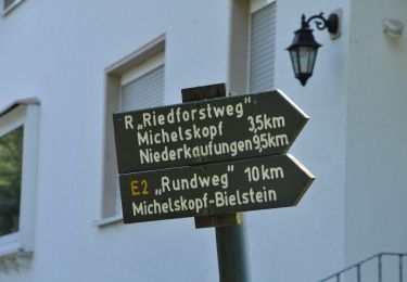
Trail created by Touristische Arbeitsgemeinschaft Märchenland der Brüder Grimm.
Symbol: Stilisiertes gelbes G mit den Profilen der Gebrüder Wilhelm und Jacob Grimm auf grünem Grund
Localización
Comentarios
Excursiones cerca
![Excursión A pie Söhrewald - Premiumweg P24 Söhrewald - Photo](https://media.geolcdn.com/t/375/260/36518c77-1898-45d3-840a-b13d5ba3729f.jpeg&format=jpg&maxdim=2)
![A pie A pie](https://static1.geolcdn.com/sitytour/trail-icons/100.png)
A pie
![](/images/other/stat-length.png)
![](https://static1.geolcdn.com/siteimages/upload/files/16400158638029165_repeat_loop_refresh_sync_direction_icon.png)
![Excursión A pie Söhrewald - Wattenbach - Neue Mühle - Photo](https://media.geolcdn.com/t/375/260/c2988172-33f8-4699-b539-b9bb903a1b59.jpeg&format=jpg&maxdim=2)
![A pie A pie](https://static1.geolcdn.com/sitytour/trail-icons/100.png)
A pie
![](/images/other/stat-length.png)
![](https://static1.geolcdn.com/siteimages/upload/files/16400158638029165_repeat_loop_refresh_sync_direction_icon.png)
![Excursión A pie Söhrewald - Eco Pfad Söhre - Photo](https://media.geolcdn.com/t/375/260/8ef385a5-b9d8-427e-8cd5-15d800871d48.jpeg&format=jpg&maxdim=2)
![A pie A pie](https://static1.geolcdn.com/sitytour/trail-icons/100.png)
A pie
![](/images/other/stat-length.png)
![](https://static1.geolcdn.com/siteimages/upload/files/16400158638029165_repeat_loop_refresh_sync_direction_icon.png)
![Excursión A pie Söhrewald - Stellbergsee - Eschenstruth - Photo](https://media.geolcdn.com/t/375/260/00201671-dab6-4650-b9c5-8b289f1f24f0.jpeg&format=jpg&maxdim=2)
![A pie A pie](https://static1.geolcdn.com/sitytour/trail-icons/100.png)
A pie
![](/images/other/stat-length.png)
![](https://static1.geolcdn.com/siteimages/upload/files/16400158638029165_repeat_loop_refresh_sync_direction_icon.png)
![Excursión A pie Söhrewald - Stellbergsee - Breitenbach - Photo](https://media.geolcdn.com/t/375/260/032608dc-851a-4041-9641-fe96126ffeaa.jpeg&format=jpg&maxdim=2)
![A pie A pie](https://static1.geolcdn.com/sitytour/trail-icons/100.png)
A pie
![](/images/other/stat-length.png)
![](https://static1.geolcdn.com/siteimages/upload/files/16400158638029165_repeat_loop_refresh_sync_direction_icon.png)
![Excursión A pie Söhrewald - Söhrewald, Rundweg 2 - Photo](https://media.geolcdn.com/t/375/260/36518c77-1898-45d3-840a-b13d5ba3729f.jpeg&format=jpg&maxdim=2)
![A pie A pie](https://static1.geolcdn.com/sitytour/trail-icons/100.png)
A pie
![](/images/other/stat-length.png)
![](https://static1.geolcdn.com/siteimages/upload/files/16400158638029165_repeat_loop_refresh_sync_direction_icon.png)
![Excursión A pie Söhrewald - Eiterhagen-Sälzerweg Richtung HeLi - Photo](https://media.geolcdn.com/t/375/260/9f08d20f-1906-4db5-8ba1-892c48a34a8b.jpeg&format=jpg&maxdim=2)
![A pie A pie](https://static1.geolcdn.com/sitytour/trail-icons/100.png)
A pie
![](/images/other/stat-length.png)
![](https://static1.geolcdn.com/siteimages/upload/files/16400158638029165_repeat_loop_refresh_sync_direction_icon.png)
![Excursión A pie Melsungen - Röhrenfurther Rundwanderweg R3 - Photo](https://media.geolcdn.com/t/375/260/a7376858-ea57-40c5-baf5-dba686938216.jpeg&format=jpg&maxdim=2)
![A pie A pie](https://static1.geolcdn.com/sitytour/trail-icons/100.png)
A pie
![](/images/other/stat-length.png)
![](https://static1.geolcdn.com/siteimages/upload/files/16400158638029165_repeat_loop_refresh_sync_direction_icon.png)
![Excursión A pie Melsungen - Röhrenfurther Rundwanderweg R2 - Photo](https://media.geolcdn.com/t/375/260/a7376858-ea57-40c5-baf5-dba686938216.jpeg&format=jpg&maxdim=2)
![A pie A pie](https://static1.geolcdn.com/sitytour/trail-icons/100.png)
A pie
![](/images/other/stat-length.png)
![](https://static1.geolcdn.com/siteimages/upload/files/16400158638029165_repeat_loop_refresh_sync_direction_icon.png)