![](/images/other/stat-length.png)
![Excursión A pie Sonnefeld - Mitwitzer Runde - Photo](https://media.geolcdn.com/t/1900/400/ext.pjpeg?maxdim=2&url=https%3A%2F%2Fmedia.geolcdn.com%2Ff%2F04c95145-31f3-479b-a477-d161234d2246.jpeg)
Mitwitzer Runde
SityTrail - itinéraires balisés pédestres
Tous les sentiers balisés d’Europe PRO
![Longitud](/images/other/stat-length.png)
Longitud
24 km
![Altitud máxima](https://static1.geolcdn.com/siteimages/upload/files/1508320355ic_sort_altitude_max_24dp.png)
Altitud máxima
463 m
![Desnivel positivo](https://static1.geolcdn.com/siteimages/upload/files/1508320355ic_sort_den_pos_24dp.png)
Desnivel positivo
580 m
![Km-Effort](/images/other/stat-length.png)
Km-Effort
32 km
![Altitud mínima](https://static1.geolcdn.com/siteimages/upload/files/1508320355ic_sort_altitude_min_24dp.png)
Altitud mínima
285 m
![Desnivel negativo](https://static1.geolcdn.com/siteimages/upload/files/1508320355ic_sort_den_neg_24dp.png)
Desnivel negativo
592 m
![Boucle](https://static1.geolcdn.com/siteimages/upload/files/16400158638029165_repeat_loop_refresh_sync_direction_icon.png)
Boucle
Sí
Baliza
Fecha de creación :
2022-02-11 16:55:12.911
Última modificación :
2022-02-11 16:55:12.911
![A pie](https://static1.geolcdn.com/sitytour/trail-icons/100.png)
7h13
Dificultad : Difícil
![Escanee este código QR para abrir la excursión en la aplicación SityTrail](https://capi.geolives.com/qq0zvz2zws4bq2lad0pu/sitytour/trails/3097069/qr.png?size=200)
Aplicación GPS de excursión GRATIS
A propósito
Ruta A pie de 24 km a descubrir en Baviera, Landkreis Coburg, Sonnefeld. Esta ruta ha sido propuesta por SityTrail - itinéraires balisés pédestres.
Descripción
Trail created by Frankenwaldverein e.V..
Symbol: Grüne KC 34 auf weißem Hintergrund
Sitio web: https://frankenwaldverein.de/
Localización
País:
Germany
Región :
Baviera
Departamento/provincia :
Landkreis Coburg
Municipio :
Sonnefeld
Localidad:
Unknown
Salida:(Dec)
Salida:(UTM)
656331 ; 5567723 (32U) N.
Comentarios
Excursiones cerca
![Excursión A pie Mitwitz - Kirchen-Wanderweg - Photo](https://media.geolcdn.com/t/375/260/ext.jpg?maxdim=2&url=https%3A%2F%2Fmedia.geolcdn.com%2Ff%2F04c95145-31f3-479b-a477-d161234d2246.jpeg)
![A pie A pie](https://static1.geolcdn.com/sitytour/trail-icons/100.png)
Kirchen-Wanderweg
A pie
Difícil
Mitwitz,
Baviera,
Landkreis Kronach,
Germany
![](/images/other/stat-length.png)
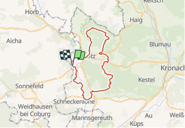
24 km | 33 km-effort
7h 27min
![](https://static1.geolcdn.com/siteimages/upload/files/16400158638029165_repeat_loop_refresh_sync_direction_icon.png)
Sí
![Excursión A pie Mitwitz - Wasserschloss-Runde - Photo](https://media.geolcdn.com/t/375/260/ext.jpg?maxdim=2&url=https%3A%2F%2Fmedia.geolcdn.com%2Ff%2Ff3efc54f-c7b6-4e75-b61f-f0e3ab5df2e3.jpeg)
![A pie A pie](https://static1.geolcdn.com/sitytour/trail-icons/100.png)
Wasserschloss-Runde
A pie
Fácil
Mitwitz,
Baviera,
Landkreis Kronach,
Germany
![](/images/other/stat-length.png)
13 km | 17,2 km-effort
3h 54min
![](https://static1.geolcdn.com/siteimages/upload/files/16400158638029165_repeat_loop_refresh_sync_direction_icon.png)
Sí
![Excursión A pie Küps - Tüschnitzer Lindenweg - Photo](https://media.geolcdn.com/t/375/260/ext.jpg?maxdim=2&url=https%3A%2F%2Fmedia.geolcdn.com%2Ff%2Fc7cbf631-9498-41f9-8d64-efc342baabfc.jpeg)
![A pie A pie](https://static1.geolcdn.com/sitytour/trail-icons/100.png)
Tüschnitzer Lindenweg
A pie
Fácil
Küps,
Baviera,
Landkreis Kronach,
Germany
![](/images/other/stat-length.png)
4,9 km | 6 km-effort
1h 21min
![](https://static1.geolcdn.com/siteimages/upload/files/16400158638029165_repeat_loop_refresh_sync_direction_icon.png)
Sí
![Excursión A pie Mitwitz - Bächleiner Weg - Photo](https://media.geolcdn.com/t/375/260/ext.jpg?maxdim=2&url=https%3A%2F%2Fmedia.geolcdn.com%2Ff%2Fd4e989bc-b6b8-4e4a-8e10-5cc0e9060f76.jpeg)
![A pie A pie](https://static1.geolcdn.com/sitytour/trail-icons/100.png)
Bächleiner Weg
A pie
Fácil
Mitwitz,
Baviera,
Landkreis Kronach,
Germany
![](/images/other/stat-length.png)
12,7 km | 15,8 km-effort
3h 34min
![](https://static1.geolcdn.com/siteimages/upload/files/16400158638029165_repeat_loop_refresh_sync_direction_icon.png)
Sí
![Excursión A pie Mitwitz - Häusles-Weg - Photo](https://media.geolcdn.com/t/375/260/ext.jpg?maxdim=2&url=https%3A%2F%2Fmedia.geolcdn.com%2Ff%2F93cf215b-b968-4f9e-9cee-e5bf5476ae3c.jpeg)
![A pie A pie](https://static1.geolcdn.com/sitytour/trail-icons/100.png)
Häusles-Weg
A pie
Fácil
Mitwitz,
Baviera,
Landkreis Kronach,
Germany
![](/images/other/stat-length.png)
7 km | 9,6 km-effort
2h 11min
![](https://static1.geolcdn.com/siteimages/upload/files/16400158638029165_repeat_loop_refresh_sync_direction_icon.png)
Sí
![Excursión A pie Mitwitz - Heunischenburg-Weg - Photo](https://media.geolcdn.com/t/375/260/ext.jpg?maxdim=2&url=https%3A%2F%2Fmedia.geolcdn.com%2Ff%2Fdc22e215-177c-4daf-b9a6-ff49482b6137.jpeg)
![A pie A pie](https://static1.geolcdn.com/sitytour/trail-icons/100.png)
Heunischenburg-Weg
A pie
Medio
Mitwitz,
Baviera,
Landkreis Kronach,
Germany
![](/images/other/stat-length.png)
18,4 km | 24 km-effort
5h 28min
![](https://static1.geolcdn.com/siteimages/upload/files/16400158638029165_repeat_loop_refresh_sync_direction_icon.png)
Sí
![Excursión A pie Mitwitz - Klausenquellen-Weg - Photo](https://media.geolcdn.com/t/375/260/ext.jpg?maxdim=2&url=https%3A%2F%2Fmedia.geolcdn.com%2Ff%2F159d4241-f450-414b-876f-e050b6c53833.jpeg)
![A pie A pie](https://static1.geolcdn.com/sitytour/trail-icons/100.png)
Klausenquellen-Weg
A pie
Fácil
Mitwitz,
Baviera,
Landkreis Kronach,
Germany
![](/images/other/stat-length.png)
6,7 km | 9 km-effort
2h 3min
![](https://static1.geolcdn.com/siteimages/upload/files/16400158638029165_repeat_loop_refresh_sync_direction_icon.png)
Sí