![](/images/other/stat-length.png)
![Excursión A pie Pleisweiler-Oberhofen - Kapellen-Pilgerweg - Photo](https://media.geolcdn.com/t/1900/400/69c464bf-606f-4503-ad4a-12d0da7335cd.jpeg&format=pjpeg&maxdim=2)
Kapellen-Pilgerweg
SityTrail - itinéraires balisés pédestres
Tous les sentiers balisés d’Europe GUIDE+
![Longitud](/images/other/stat-length.png)
![Altitud máxima](https://static1.geolcdn.com/siteimages/upload/files/1508320355ic_sort_altitude_max_24dp.png)
![Desnivel positivo](https://static1.geolcdn.com/siteimages/upload/files/1508320355ic_sort_den_pos_24dp.png)
![Km-Effort](/images/other/stat-length.png)
![Altitud mínima](https://static1.geolcdn.com/siteimages/upload/files/1508320355ic_sort_altitude_min_24dp.png)
![Desnivel negativo](https://static1.geolcdn.com/siteimages/upload/files/1508320355ic_sort_den_neg_24dp.png)
![Boucle](https://static1.geolcdn.com/siteimages/upload/files/16400158638029165_repeat_loop_refresh_sync_direction_icon.png)
![A pie](https://static1.geolcdn.com/sitytour/trail-icons/100.png)
23h17
Dificultad : Muy difícil
![Escanee este código QR para abrir la excursión en la aplicación SityTrail](https://capi.geolives.com/qq0zvz2zws4bq2lad0pu/sitytour/trails/3096811/qr.png?size=200)
Aplicación GPS de excursión GRATIS
A propósito
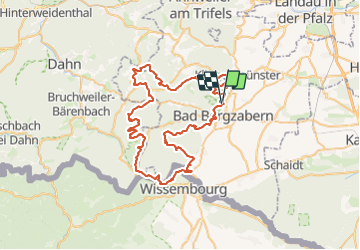
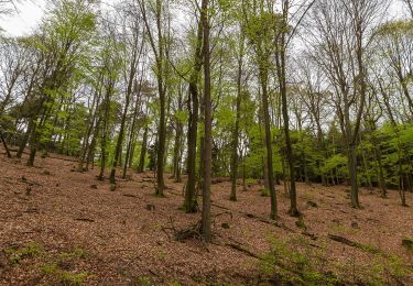
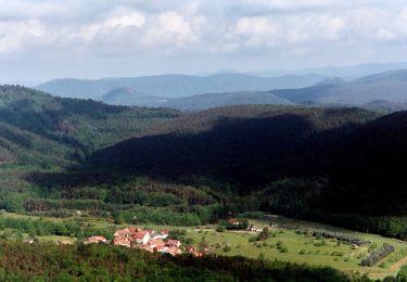
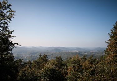
Ruta A pie de 72 km a descubrir en Renania-Palatinado, Landkreis Südliche Weinstraße, Pleisweiler-Oberhofen. Esta ruta ha sido propuesta por SityTrail - itinéraires balisés pédestres.
Descripción
Trail created by Tourismusverein Südliche Weinstrasse Bad Bergzabern.
Pleisweiler: Lücke in Natur noch nicht markiert (Mai 2016)
Symbol: weißes Kreuz in lila Raute
Localización
Comentarios
Excursiones cerca
![Excursión A pie Bad Bergzabern - Rund um den Steinkopf, Blankenborn - Photo](https://media.geolcdn.com/t/375/260/a1a875da-220a-445f-90bc-b6a55bf8490a.jpeg&format=jpg&maxdim=2)
![A pie A pie](https://static1.geolcdn.com/sitytour/trail-icons/100.png)
A pie
![](/images/other/stat-length.png)
![](https://static1.geolcdn.com/siteimages/upload/files/16400158638029165_repeat_loop_refresh_sync_direction_icon.png)
![Excursión A pie Gleiszellen-Gleishorbach - Karlsplatzweg, Klingenmüster - Photo](https://media.geolcdn.com/t/375/260/ac37879d-acc5-4857-b912-f719f89895bb.jpeg&format=jpg&maxdim=2)
![A pie A pie](https://static1.geolcdn.com/sitytour/trail-icons/100.png)
A pie
![](/images/other/stat-length.png)
![](https://static1.geolcdn.com/siteimages/upload/files/16400158638029165_repeat_loop_refresh_sync_direction_icon.png)
![Excursión A pie Gleiszellen-Gleishorbach - Gleiszellen: Sauhausbrunnen-Weg - Photo](https://media.geolcdn.com/t/375/260/587aa085-4553-4445-bd7d-17a36fbe529e.jpeg&format=jpg&maxdim=2)
![A pie A pie](https://static1.geolcdn.com/sitytour/trail-icons/100.png)
A pie
![](/images/other/stat-length.png)
![](https://static1.geolcdn.com/siteimages/upload/files/16400158638029165_repeat_loop_refresh_sync_direction_icon.png)
![Excursión A pie Gleiszellen-Gleishorbach - Gleiszellen: Mischwald-Wanderweg - Photo](https://media.geolcdn.com/t/375/260/587aa085-4553-4445-bd7d-17a36fbe529e.jpeg&format=jpg&maxdim=2)
![A pie A pie](https://static1.geolcdn.com/sitytour/trail-icons/100.png)
A pie
![](/images/other/stat-length.png)
![](https://static1.geolcdn.com/siteimages/upload/files/16400158638029165_repeat_loop_refresh_sync_direction_icon.png)
![Excursión A pie Bad Bergzabern - Bad Bergzabern: Tabernae-Montanus-Weg - Photo](https://media.geolcdn.com/t/375/260/3ce2d107-4a94-4809-8088-a16ba0756f56.jpeg&format=jpg&maxdim=2)
![A pie A pie](https://static1.geolcdn.com/sitytour/trail-icons/100.png)
A pie
![](/images/other/stat-length.png)
![](https://static1.geolcdn.com/siteimages/upload/files/16400158638029165_repeat_loop_refresh_sync_direction_icon.png)
![Excursión A pie Dörrenbach - Weg der Aussichten, Dörrenbach - Photo](https://media.geolcdn.com/t/375/260/ef1a6a3b-6757-4ea4-a794-b6e50608a517.jpeg&format=jpg&maxdim=2)
![A pie A pie](https://static1.geolcdn.com/sitytour/trail-icons/100.png)
A pie
![](/images/other/stat-length.png)
![](https://static1.geolcdn.com/siteimages/upload/files/16400158638029165_repeat_loop_refresh_sync_direction_icon.png)
![Excursión A pie Oberotterbach - Weg der Geschichte, Oberotterbach - Photo](https://media.geolcdn.com/t/375/260/612ddb44-dd60-4898-8629-e66921918ec9.jpeg&format=jpg&maxdim=2)
![A pie A pie](https://static1.geolcdn.com/sitytour/trail-icons/100.png)
A pie
![](/images/other/stat-length.png)
![](https://static1.geolcdn.com/siteimages/upload/files/16400158638029165_repeat_loop_refresh_sync_direction_icon.png)
![Excursión A pie Oberotterbach - Dornröschen Rundwanderweg, Dörrenbach - Photo](https://media.geolcdn.com/t/375/260/612ddb44-dd60-4898-8629-e66921918ec9.jpeg&format=jpg&maxdim=2)
![A pie A pie](https://static1.geolcdn.com/sitytour/trail-icons/100.png)
A pie
![](/images/other/stat-length.png)
![](https://static1.geolcdn.com/siteimages/upload/files/16400158638029165_repeat_loop_refresh_sync_direction_icon.png)
![Excursión A pie Münchweiler am Klingbach - Quellenweg Klingenmünster - Photo](https://media.geolcdn.com/t/375/260/606d8b61-6ea9-484e-989c-743742a4e664.jpeg&format=jpg&maxdim=2)
![A pie A pie](https://static1.geolcdn.com/sitytour/trail-icons/100.png)
A pie
![](/images/other/stat-length.png)
![](https://static1.geolcdn.com/siteimages/upload/files/16400158638029165_repeat_loop_refresh_sync_direction_icon.png)