![](/images/other/stat-length.png)
![Excursión A pie Biebelried - Kulturweg Biebelried](https://media.geolcdn.com/t/1900/400/ext.pjpeg?maxdim=2&url=https%3A%2F%2Fmedia.geolcdn.com%2Ff%2F301aa644-3832-49d0-b2ce-3a783972bb69.jpeg)
Kulturweg Biebelried "Das steinerne Herz Mainfrankens"
SityTrail - itinéraires balisés pédestres
Tous les sentiers balisés d’Europe PRO
![Longitud](/images/other/stat-length.png)
Longitud
5,4 km
![Altitud máxima](https://static1.geolcdn.com/siteimages/upload/files/1508320355ic_sort_altitude_max_24dp.png)
Altitud máxima
296 m
![Desnivel positivo](https://static1.geolcdn.com/siteimages/upload/files/1508320355ic_sort_den_pos_24dp.png)
Desnivel positivo
56 m
![Km-Effort](/images/other/stat-length.png)
Km-Effort
6,1 km
![Altitud mínima](https://static1.geolcdn.com/siteimages/upload/files/1508320355ic_sort_altitude_min_24dp.png)
Altitud mínima
259 m
![Desnivel negativo](https://static1.geolcdn.com/siteimages/upload/files/1508320355ic_sort_den_neg_24dp.png)
Desnivel negativo
42 m
![Boucle](https://static1.geolcdn.com/siteimages/upload/files/16400158638029165_repeat_loop_refresh_sync_direction_icon.png)
Boucle
No
Baliza
Fecha de creación :
2022-02-11 16:37:11.758
Última modificación :
2022-02-11 16:37:11.758
![A pie](https://static1.geolcdn.com/sitytour/trail-icons/100.png)
1h22
Dificultad : Fácil
![Escanee este código QR para abrir la excursión en la aplicación SityTrail](https://capi.geolives.com/qq0zvz2zws4bq2lad0pu/sitytour/trails/3096583/qr.png?size=200)
Aplicación GPS de excursión GRATIS
A propósito
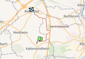
Ruta A pie de 5,4 km a descubrir en Baviera, Landkreis Kitzingen, Biebelried. Esta ruta ha sido propuesta por SityTrail - itinéraires balisés pédestres.
Descripción
Trail created by Archäologisches Spessartprojekt.
Symbol: Gelbes EU-Schiffchen auf blauem Grund
Sitio web: https://www.spessartprojekt.de/wordpress/?page_id=10123
Fotos
"
data-pinterest-text="Pin it"
data-tweet-text="share on twitter"
data-facebook-share-url="https://www.sitytrail.com/es/trails/3096583-biebelried--kulturweg-biebelried-xdas-steinerne-herz-mainfrankensx/?photo=0#lg=1&slide=0"
data-twitter-share-url="https://www.sitytrail.com/es/trails/3096583-biebelried--kulturweg-biebelried-xdas-steinerne-herz-mainfrankensx/?photo=0#lg=1&slide=0"
data-googleplus-share-url="https://www.sitytrail.com/es/trails/3096583-biebelried--kulturweg-biebelried-xdas-steinerne-herz-mainfrankensx/?photo=0#lg=1&slide=0"
data-pinterest-share-url="https://www.sitytrail.com/es/trails/3096583-biebelried--kulturweg-biebelried-xdas-steinerne-herz-mainfrankensx/?photo=0#lg=1&slide=0">
"
data-pinterest-text="Pin it"
data-tweet-text="share on twitter"
data-facebook-share-url="https://www.sitytrail.com/es/trails/3096583-biebelried--kulturweg-biebelried-xdas-steinerne-herz-mainfrankensx/?photo=1#lg=1&slide=1"
data-twitter-share-url="https://www.sitytrail.com/es/trails/3096583-biebelried--kulturweg-biebelried-xdas-steinerne-herz-mainfrankensx/?photo=1#lg=1&slide=1"
data-googleplus-share-url="https://www.sitytrail.com/es/trails/3096583-biebelried--kulturweg-biebelried-xdas-steinerne-herz-mainfrankensx/?photo=1#lg=1&slide=1"
data-pinterest-share-url="https://www.sitytrail.com/es/trails/3096583-biebelried--kulturweg-biebelried-xdas-steinerne-herz-mainfrankensx/?photo=1#lg=1&slide=1">
"
data-pinterest-text="Pin it"
data-tweet-text="share on twitter"
data-facebook-share-url="https://www.sitytrail.com/es/trails/3096583-biebelried--kulturweg-biebelried-xdas-steinerne-herz-mainfrankensx/?photo=2#lg=1&slide=2"
data-twitter-share-url="https://www.sitytrail.com/es/trails/3096583-biebelried--kulturweg-biebelried-xdas-steinerne-herz-mainfrankensx/?photo=2#lg=1&slide=2"
data-googleplus-share-url="https://www.sitytrail.com/es/trails/3096583-biebelried--kulturweg-biebelried-xdas-steinerne-herz-mainfrankensx/?photo=2#lg=1&slide=2"
data-pinterest-share-url="https://www.sitytrail.com/es/trails/3096583-biebelried--kulturweg-biebelried-xdas-steinerne-herz-mainfrankensx/?photo=2#lg=1&slide=2">
![Excursión A pie Biebelried - Kulturweg Biebelried Excursión A pie Biebelried - Kulturweg Biebelried](https://media.geolcdn.com/t/170/100/16ef5e6e-8abf-480e-b461-24d8b844c301.jpeg&format=jpg&maxdim=2)
![Excursión A pie Biebelried - Kulturweg Biebelried Excursión A pie Biebelried - Kulturweg Biebelried](https://media.geolcdn.com/t/170/100/0be0b655-b961-4c71-a7e3-6b26317a809e.jpeg&format=jpg&maxdim=2)
![Excursión A pie Biebelried - Kulturweg Biebelried Excursión A pie Biebelried - Kulturweg Biebelried](https://media.geolcdn.com/t/170/100/301aa644-3832-49d0-b2ce-3a783972bb69.jpeg&format=jpg&maxdim=2)
Localización
País:
Germany
Región :
Baviera
Departamento/provincia :
Landkreis Kitzingen
Municipio :
Biebelried
Localidad:
Unknown
Salida:(Dec)
Salida:(UTM)
578398 ; 5509575 (32U) N.
Comentarios
Excursiones cerca
![Excursión A pie Randersacker - Kulturweg](https://media.geolcdn.com/t/375/260/ext.jpg?maxdim=2&url=https%3A%2F%2Fmedia.geolcdn.com%2Ff%2F12dc0318-530b-4c2a-bdf8-f4d1fffd1787.jpeg)
![A pie A pie](https://static1.geolcdn.com/sitytour/trail-icons/100.png)
Kulturweg "Charme der zweiten Reihe"
A pie
Fácil
Randersacker,
Baviera,
Landkreis Würzburg,
Germany
![](/images/other/stat-length.png)
13,7 km | 17,6 km-effort
3h 59min
![](https://static1.geolcdn.com/siteimages/upload/files/16400158638029165_repeat_loop_refresh_sync_direction_icon.png)
Sí
![Excursión A pie Sommerhausen - Panoramaweg - Photo](https://media.geolcdn.com/t/375/260/ext.jpg?maxdim=2&url=https%3A%2F%2Fmedia.geolcdn.com%2Ff%2F2250dbab-18ec-4474-bcf6-c9bd78d52258.jpeg)
![A pie A pie](https://static1.geolcdn.com/sitytour/trail-icons/100.png)
Panoramaweg
A pie
Fácil
Sommerhausen,
Baviera,
Landkreis Würzburg,
Germany
![](/images/other/stat-length.png)
7 km | 8,5 km-effort
1h 56min
![](https://static1.geolcdn.com/siteimages/upload/files/16400158638029165_repeat_loop_refresh_sync_direction_icon.png)
No
![Excursión A pie Randersacker - Weinwanderung 'Dabug' - Photo](https://media.geolcdn.com/t/375/260/ext.jpg?maxdim=2&url=https%3A%2F%2Fmedia.geolcdn.com%2Ff%2F12dc0318-530b-4c2a-bdf8-f4d1fffd1787.jpeg)
![A pie A pie](https://static1.geolcdn.com/sitytour/trail-icons/100.png)
Weinwanderung 'Dabug'
A pie
Fácil
Randersacker,
Baviera,
Landkreis Würzburg,
Germany
![](/images/other/stat-length.png)
9,7 km | 12,5 km-effort
2h 50min
![](https://static1.geolcdn.com/siteimages/upload/files/16400158638029165_repeat_loop_refresh_sync_direction_icon.png)
Sí
![Excursión A pie Sommerhausen - Sommerhausen - Sulzfeld - Photo](https://media.geolcdn.com/t/375/260/ext.jpg?maxdim=2&url=https%3A%2F%2Fmedia.geolcdn.com%2Ff%2Fa751f7f2-e042-429b-94a4-f89ddb178483.jpeg)
![A pie A pie](https://static1.geolcdn.com/sitytour/trail-icons/100.png)
Sommerhausen - Sulzfeld
A pie
Fácil
Sommerhausen,
Baviera,
Landkreis Würzburg,
Germany
![](/images/other/stat-length.png)
8,9 km | 11,1 km-effort
2h 30min
![](https://static1.geolcdn.com/siteimages/upload/files/16400158638029165_repeat_loop_refresh_sync_direction_icon.png)
No
![Excursión A pie Sommerhausen - Weinbergsweg - Photo](https://media.geolcdn.com/t/375/260/ext.jpg?maxdim=2&url=https%3A%2F%2Fmedia.geolcdn.com%2Ff%2F2250dbab-18ec-4474-bcf6-c9bd78d52258.jpeg)
![A pie A pie](https://static1.geolcdn.com/sitytour/trail-icons/100.png)
Weinbergsweg
A pie
Fácil
Sommerhausen,
Baviera,
Landkreis Würzburg,
Germany
![](/images/other/stat-length.png)
3,4 km | 4,3 km-effort
58min
![](https://static1.geolcdn.com/siteimages/upload/files/16400158638029165_repeat_loop_refresh_sync_direction_icon.png)
No
![Excursión A pie Sommerhausen - Wein-Kultur-Weg - Photo](https://media.geolcdn.com/t/375/260/ext.jpg?maxdim=2&url=https%3A%2F%2Fmedia.geolcdn.com%2Ff%2Fa751f7f2-e042-429b-94a4-f89ddb178483.jpeg)
![A pie A pie](https://static1.geolcdn.com/sitytour/trail-icons/100.png)
Wein-Kultur-Weg
A pie
Fácil
Sommerhausen,
Baviera,
Landkreis Würzburg,
Germany
![](/images/other/stat-length.png)
3,2 km | 4,2 km-effort
56min
![](https://static1.geolcdn.com/siteimages/upload/files/16400158638029165_repeat_loop_refresh_sync_direction_icon.png)
Sí
![Excursión A pie Eibelstadt - Eichenlohe-Weg - Photo](https://media.geolcdn.com/t/375/260/ext.jpg?maxdim=2&url=https%3A%2F%2Fmedia.geolcdn.com%2Ff%2Fa751f7f2-e042-429b-94a4-f89ddb178483.jpeg)
![A pie A pie](https://static1.geolcdn.com/sitytour/trail-icons/100.png)
Eichenlohe-Weg
A pie
Fácil
Eibelstadt,
Baviera,
Landkreis Würzburg,
Germany
![](/images/other/stat-length.png)
5,7 km | 7,1 km-effort
1h 36min
![](https://static1.geolcdn.com/siteimages/upload/files/16400158638029165_repeat_loop_refresh_sync_direction_icon.png)
No
![Excursión A pie Sommerhausen - Wanderweg der Ortsgeschichte - Photo](https://media.geolcdn.com/t/375/260/ext.jpg?maxdim=2&url=https%3A%2F%2Fmedia.geolcdn.com%2Ff%2F2250dbab-18ec-4474-bcf6-c9bd78d52258.jpeg)
![A pie A pie](https://static1.geolcdn.com/sitytour/trail-icons/100.png)
Wanderweg der Ortsgeschichte
A pie
Fácil
Sommerhausen,
Baviera,
Landkreis Würzburg,
Germany
![](/images/other/stat-length.png)
5,1 km | 6,6 km-effort
1h 30min
![](https://static1.geolcdn.com/siteimages/upload/files/16400158638029165_repeat_loop_refresh_sync_direction_icon.png)
No
![Excursión A pie Marktsteft - Rundwanderweg Panoramaweg in Marktsteft - Photo](https://media.geolcdn.com/t/375/260/ext.jpg?maxdim=2&url=https%3A%2F%2Fstatic1.geolcdn.com%2Fsiteimages%2Fupload%2Ffiles%2F1545311037marcheuse_200dpi.jpg)
![A pie A pie](https://static1.geolcdn.com/sitytour/trail-icons/100.png)
Rundwanderweg Panoramaweg in Marktsteft
A pie
Fácil
Marktsteft,
Baviera,
Landkreis Kitzingen,
Germany
![](/images/other/stat-length.png)
5,6 km | 6,4 km-effort
1h 26min
![](https://static1.geolcdn.com/siteimages/upload/files/16400158638029165_repeat_loop_refresh_sync_direction_icon.png)
Sí