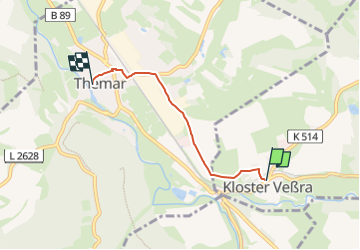
![](/images/other/stat-length.png)
![Excursión A pie Kloster Veßra - Themar-Rundwanderweg Blau - Photo](https://media.geolcdn.com/t/1900/400/224b2fe3-a292-4bca-a3c9-30e606dd8eee.jpeg&format=pjpeg&maxdim=2)
Themar-Rundwanderweg Blau
SityTrail - itinéraires balisés pédestres
Tous les sentiers balisés d’Europe GUIDE+
![Longitud](/images/other/stat-length.png)
![Altitud máxima](https://static1.geolcdn.com/siteimages/upload/files/1508320355ic_sort_altitude_max_24dp.png)
![Desnivel positivo](https://static1.geolcdn.com/siteimages/upload/files/1508320355ic_sort_den_pos_24dp.png)
![Km-Effort](/images/other/stat-length.png)
![Altitud mínima](https://static1.geolcdn.com/siteimages/upload/files/1508320355ic_sort_altitude_min_24dp.png)
![Desnivel negativo](https://static1.geolcdn.com/siteimages/upload/files/1508320355ic_sort_den_neg_24dp.png)
![Boucle](https://static1.geolcdn.com/siteimages/upload/files/16400158638029165_repeat_loop_refresh_sync_direction_icon.png)
![A pie](https://static1.geolcdn.com/sitytour/trail-icons/100.png)
50m
Dificultad : Fácil
![Escanee este código QR para abrir la excursión en la aplicación SityTrail](https://capi.geolives.com/qq0zvz2zws4bq2lad0pu/sitytour/trails/3096353/qr.png?size=200)
Aplicación GPS de excursión GRATIS
A propósito
Ruta A pie de 3,2 km a descubrir en Turingia, Landkreis Hildburghausen, Kloster Veßra. Esta ruta ha sido propuesta por SityTrail - itinéraires balisés pédestres.
Descripción
Infoportal der Verwaltungsgemeinschaft Feldstein mit den Mitgliedsgemeinden Ahlstädt, Bischofrod, Beinerstadt, Dingsleben, Ehrenberg, Eichenberg, Grimmelshausen, Grub, Henfstädt, Kloster Veßra, Lengfeld, Marisfeld, Oberstadt, Reurieth, Schmeheim und St. Bernhard.
Sitio web: http://www.themar.de/public/tourismus/tourismus-freizeit-geocaching.aspx
Localización
Comentarios
Excursiones cerca
![Excursión A pie Themar - Themar-Rundwanderweg Grün - Photo](https://media.geolcdn.com/t/375/260/fa57ddcc-ea52-47e2-a87f-cb5d71c9b16e.jpeg&format=jpg&maxdim=2)
![A pie A pie](https://static1.geolcdn.com/sitytour/trail-icons/100.png)
A pie
![](/images/other/stat-length.png)
![](https://static1.geolcdn.com/siteimages/upload/files/16400158638029165_repeat_loop_refresh_sync_direction_icon.png)
![Excursión A pie Themar - Themar-Rundwanderweg Rot - Photo](https://media.geolcdn.com/t/375/260/fa57ddcc-ea52-47e2-a87f-cb5d71c9b16e.jpeg&format=jpg&maxdim=2)
![A pie A pie](https://static1.geolcdn.com/sitytour/trail-icons/100.png)
A pie
![](/images/other/stat-length.png)
![](https://static1.geolcdn.com/siteimages/upload/files/16400158638029165_repeat_loop_refresh_sync_direction_icon.png)