


4,7 km | 6,9 km-effort
![Excursión A pie Lemgo - Rundwanderweg A2 [Lemgoer Mark] - Photo](https://media.geolcdn.com/t/1900/400/1f940cf8-94ed-4c63-a4c9-cee2b64daebb.jpeg&format=pjpeg&maxdim=2)

Tous les sentiers balisés d’Europe GUIDE+


Aplicación GPS de excursión GRATIS
 SityTrail
IGN / Institutos geográficos
SityTrail World
El mundo es suyo
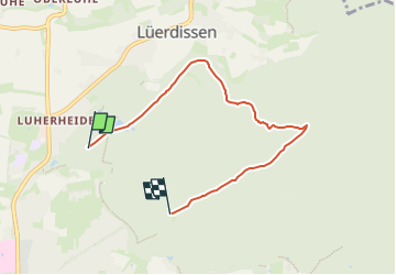
Ruta A pie de 4,9 km a descubrir en Renania del Norte-Westfalia, Kreis Lippe, Lemgo. Esta ruta ha sido propuesta por SityTrail - itinéraires balisés pédestres.
ascent und descent stammen aus dem GPS-Log und können entsprechend ungenau sein.
![Excursión A pie Lemgo - Rundwanderweg A2 [Lemgoer Mark] - Photo 1](https://media.geolcdn.com/t/2048/auto/51667f3c-ae2c-4d12-9c30-cbda0e8be75e.jpeg&format=jpg&maxdim=0 "Excursión A pie Lemgo - Rundwanderweg A2 [Lemgoer Mark] - Photo 1")
![Excursión A pie Lemgo - Rundwanderweg A2 [Lemgoer Mark] - Photo 2](https://media.geolcdn.com/t/2048/auto/ea93b544-a21a-4a56-9eec-ab359ac0d793.jpeg&format=jpg&maxdim=0 "Excursión A pie Lemgo - Rundwanderweg A2 [Lemgoer Mark] - Photo 2")
![Excursión A pie Lemgo - Rundwanderweg A2 [Lemgoer Mark] - Photo 3](https://media.geolcdn.com/t/2048/auto/e9aa1b05-54a9-423b-8db7-e6c033b70d1b.jpeg&format=jpg&maxdim=0 "Excursión A pie Lemgo - Rundwanderweg A2 [Lemgoer Mark] - Photo 3")
![Excursión A pie Lemgo - Rundwanderweg A2 [Lemgoer Mark] - Photo 4](https://media.geolcdn.com/t/2048/auto/5bff9ce9-f7a6-42c4-8d59-040315fa5f96.jpeg&format=jpg&maxdim=0 "Excursión A pie Lemgo - Rundwanderweg A2 [Lemgoer Mark] - Photo 4")
![Excursión A pie Lemgo - Rundwanderweg A2 [Lemgoer Mark] - Photo 5](https://media.geolcdn.com/t/2048/auto/65009e60-8da4-421b-b3e4-92e35d707096.jpeg&format=jpg&maxdim=0 "Excursión A pie Lemgo - Rundwanderweg A2 [Lemgoer Mark] - Photo 5")
![Excursión A pie Lemgo - Rundwanderweg A2 [Lemgoer Mark] - Photo 6](https://media.geolcdn.com/t/2048/auto/f5cf0e76-13bd-4ad2-9fb2-82ba479148f8.jpeg&format=jpg&maxdim=0 "Excursión A pie Lemgo - Rundwanderweg A2 [Lemgoer Mark] - Photo 6")
![Excursión A pie Lemgo - Rundwanderweg A2 [Lemgoer Mark] - Photo 7](https://media.geolcdn.com/t/2048/auto/1a2a1aee-00fe-4ee2-84b2-e64bd03124a0.jpeg&format=jpg&maxdim=0 "Excursión A pie Lemgo - Rundwanderweg A2 [Lemgoer Mark] - Photo 7")
![Excursión A pie Lemgo - Rundwanderweg A2 [Lemgoer Mark] - Photo 8](https://media.geolcdn.com/t/2048/auto/bb47df44-f4e3-4d16-8f1f-fa41522b94b9.jpeg&format=jpg&maxdim=0 "Excursión A pie Lemgo - Rundwanderweg A2 [Lemgoer Mark] - Photo 8")
![Excursión A pie Lemgo - Rundwanderweg A2 [Lemgoer Mark] - Photo 9](https://media.geolcdn.com/t/2048/auto/8a8a8473-4a5f-46ac-92ce-75868f79121b.jpeg&format=jpg&maxdim=0 "Excursión A pie Lemgo - Rundwanderweg A2 [Lemgoer Mark] - Photo 9")
![Excursión A pie Lemgo - Rundwanderweg A2 [Lemgoer Mark] - Photo 10](https://media.geolcdn.com/t/2048/auto/1f940cf8-94ed-4c63-a4c9-cee2b64daebb.jpeg&format=jpg&maxdim=0 "Excursión A pie Lemgo - Rundwanderweg A2 [Lemgoer Mark] - Photo 10")
![Excursión A pie Lemgo - Rundwanderweg A3 [Lemgoer Mark] - Photo](https://media.geolcdn.com/t/375/260/1f940cf8-94ed-4c63-a4c9-cee2b64daebb.jpeg&format=jpg&maxdim=2)
A pie
![Excursión A pie Lemgo - Rundwanderweg A1 [Lemgoer Mark] - Photo](https://media.geolcdn.com/t/375/260/15f8477e-f08f-4fab-8113-5705b0ff22a6.jpeg&format=jpg&maxdim=2)
A pie
![Excursión A pie Lemgo - Rundwanderweg [Lemgoer Mark] - Photo](https://media.geolcdn.com/t/375/260/ext.jpg?maxdim=2&url=https%3A%2F%2Fstatic1.geolcdn.com%2Fsiteimages%2Fupload%2Ffiles%2F1545311037marcheuse_200dpi.jpg)
A pie
A pie
A pie