![](/images/other/stat-length.png)
![Excursión A pie Unknown - Coburger Rundwanderweg - Photo](https://media.geolcdn.com/t/1900/400/4d36f45d-4bdf-4096-86be-bc3b2e36b2c5.jpeg&format=pjpeg&maxdim=2)
Coburger Rundwanderweg
SityTrail - itinéraires balisés pédestres
Tous les sentiers balisés d’Europe GUIDE+
![Longitud](/images/other/stat-length.png)
Longitud
34 km
![Altitud máxima](https://static1.geolcdn.com/siteimages/upload/files/1508320355ic_sort_altitude_max_24dp.png)
Altitud máxima
452 m
![Desnivel positivo](https://static1.geolcdn.com/siteimages/upload/files/1508320355ic_sort_den_pos_24dp.png)
Desnivel positivo
712 m
![Km-Effort](/images/other/stat-length.png)
Km-Effort
43 km
![Altitud mínima](https://static1.geolcdn.com/siteimages/upload/files/1508320355ic_sort_altitude_min_24dp.png)
Altitud mínima
280 m
![Desnivel negativo](https://static1.geolcdn.com/siteimages/upload/files/1508320355ic_sort_den_neg_24dp.png)
Desnivel negativo
704 m
![Boucle](https://static1.geolcdn.com/siteimages/upload/files/16400158638029165_repeat_loop_refresh_sync_direction_icon.png)
Boucle
Sí
Baliza
Fecha de creación :
2022-02-11 15:47:34.135
Última modificación :
2022-02-11 15:47:34.135
![A pie](https://static1.geolcdn.com/sitytour/trail-icons/100.png)
9h53
Dificultad : Muy difícil
![Escanee este código QR para abrir la excursión en la aplicación SityTrail](https://capi.geolives.com/qq0zvz2zws4bq2lad0pu/sitytour/trails/3095236/qr.png?size=200)
Aplicación GPS de excursión GRATIS
A propósito
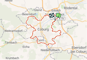
Ruta A pie de 34 km a descubrir en Baviera, Coburgo. Esta ruta ha sido propuesta por SityTrail - itinéraires balisés pédestres.
Descripción
mapped by roamingbecki 2014-03-16
Symbol: Red C on white ground
Sitio web: http://www.wandern-im-coburger-land.de/coburger_rundwanderweg.html
Localización
País:
Germany
Región :
Baviera
Departamento/provincia :
Coburgo
Municipio :
Unknown
Localidad:
Unknown
Salida:(Dec)
Salida:(UTM)
642426 ; 5570966 (32U) N.
Comentarios
Excursiones cerca
![Excursión A pie Ebersdorf b.Coburg - Rundwanderweg Ebersdorf Route 2 - Photo](https://media.geolcdn.com/t/375/260/44e3075a-3f4f-4128-80a8-f7cddf43e16e.jpeg&format=jpg&maxdim=2)
![A pie A pie](https://static1.geolcdn.com/sitytour/trail-icons/100.png)
Rundwanderweg Ebersdorf Route 2
A pie
Fácil
Ebersdorf b.Coburg,
Baviera,
Landkreis Coburg,
Germany
![](/images/other/stat-length.png)
3,7 km | 4,7 km-effort
1h 3min
![](https://static1.geolcdn.com/siteimages/upload/files/16400158638029165_repeat_loop_refresh_sync_direction_icon.png)
No
![Excursión A pie Rödental - Emil-Rädlein-Weg - Photo](https://media.geolcdn.com/t/375/260/800c4313-e081-419c-86df-35ea7ac39f16.jpeg&format=jpg&maxdim=2)
![A pie A pie](https://static1.geolcdn.com/sitytour/trail-icons/100.png)
Emil-Rädlein-Weg
A pie
Muy difícil
Rödental,
Baviera,
Landkreis Coburg,
Germany
![](/images/other/stat-length.png)
40 km | 51 km-effort
11h 40min
![](https://static1.geolcdn.com/siteimages/upload/files/16400158638029165_repeat_loop_refresh_sync_direction_icon.png)
No
![Excursión A pie Ebersdorf b.Coburg - Rundwanderweg Ebersdorf Route 1 - Photo](https://media.geolcdn.com/t/375/260/9e8afe0a-7c70-4cfb-b46e-f8f361752fa6.jpeg&format=jpg&maxdim=2)
![A pie A pie](https://static1.geolcdn.com/sitytour/trail-icons/100.png)
Rundwanderweg Ebersdorf Route 1
A pie
Fácil
Ebersdorf b.Coburg,
Baviera,
Landkreis Coburg,
Germany
![](/images/other/stat-length.png)
3,6 km | 4,6 km-effort
1h 2min
![](https://static1.geolcdn.com/siteimages/upload/files/16400158638029165_repeat_loop_refresh_sync_direction_icon.png)
No
![Excursión A pie Rödental - Rundwanderweg Einberger Wald - Photo](https://media.geolcdn.com/t/375/260/7c3b7500-b5ff-4f92-8e19-e994d375a41f.jpeg&format=jpg&maxdim=2)
![A pie A pie](https://static1.geolcdn.com/sitytour/trail-icons/100.png)
Rundwanderweg Einberger Wald
A pie
Fácil
Rödental,
Baviera,
Landkreis Coburg,
Germany
![](/images/other/stat-length.png)
3,2 km | 4,3 km-effort
58min
![](https://static1.geolcdn.com/siteimages/upload/files/16400158638029165_repeat_loop_refresh_sync_direction_icon.png)
No
![Excursión A pie - Amtsbotenweg - Photo](https://media.geolcdn.com/t/375/260/ext.jpg?maxdim=2&url=https%3A%2F%2Fstatic1.geolcdn.com%2Fsiteimages%2Fupload%2Ffiles%2F1545311037marcheuse_200dpi.jpg)
![A pie A pie](https://static1.geolcdn.com/sitytour/trail-icons/100.png)
![Excursión Senderismo - w-duitsland-wandelroute-coburg - Photo](https://media.geolcdn.com/t/375/260/ext.jpg?maxdim=2&url=https%3A%2F%2Fstatic1.geolcdn.com%2Fsiteimages%2Fupload%2Ffiles%2F1553511878bg_sport_marche.png)
![Senderismo Senderismo](https://static1.geolcdn.com/sitytour/trail-icons/101.png)
w-duitsland-wandelroute-coburg
Senderismo
Muy fácil
,
Baviera,
Coburgo,
Germany
![](/images/other/stat-length.png)
17,1 km | 23 km-effort
Desconocido
![](https://static1.geolcdn.com/siteimages/upload/files/16400158638029165_repeat_loop_refresh_sync_direction_icon.png)
Sí