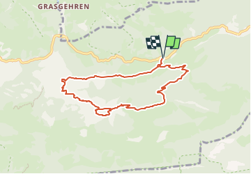
![](/images/other/stat-length.png)
![Excursión A pie Obermaiselstein - Beslerrunde - Photo](https://media.geolcdn.com/t/1900/400/e1e8dae7-0c73-499a-b72a-b25dc7b51a29.jpeg&format=pjpeg&maxdim=2)
Beslerrunde
SityTrail - itinéraires balisés pédestres
Tous les sentiers balisés d’Europe GUIDE+
![Longitud](/images/other/stat-length.png)
![Altitud máxima](https://static1.geolcdn.com/siteimages/upload/files/1508320355ic_sort_altitude_max_24dp.png)
![Desnivel positivo](https://static1.geolcdn.com/siteimages/upload/files/1508320355ic_sort_den_pos_24dp.png)
![Km-Effort](/images/other/stat-length.png)
![Altitud mínima](https://static1.geolcdn.com/siteimages/upload/files/1508320355ic_sort_altitude_min_24dp.png)
![Desnivel negativo](https://static1.geolcdn.com/siteimages/upload/files/1508320355ic_sort_den_neg_24dp.png)
![Boucle](https://static1.geolcdn.com/siteimages/upload/files/16400158638029165_repeat_loop_refresh_sync_direction_icon.png)
![A pie](https://static1.geolcdn.com/sitytour/trail-icons/100.png)
3h32
Dificultad : Fácil
![Escanee este código QR para abrir la excursión en la aplicación SityTrail](https://capi.geolives.com/qq0zvz2zws4bq2lad0pu/sitytour/trails/3094437/qr.png?size=200)
Aplicación GPS de excursión GRATIS
A propósito
Ruta A pie de 8,1 km a descubrir en Baviera, Landkreis Oberallgäu, Obermaiselstein. Esta ruta ha sido propuesta por SityTrail - itinéraires balisés pédestres.
Descripción
Trail created by Gemeinde Obermaiselstein.
Kein simples Symbol verfügbar. Auf den Wanderwegweisern wird ein Logo mit der Beschriftung "Naturpark Nagelfluhkette - Premium-Wanderweg Alpin Beslerrunde" in einem grün-violetten Logo verwendet.
Localización
Comentarios
Excursiones cerca
![Excursión A pie Oberstdorf - K - Über Kornau zum Bergkristall - Photo](https://media.geolcdn.com/t/375/260/15d40373-407b-42c0-8a77-b924c42bcedd.jpeg&format=jpg&maxdim=2)
![A pie A pie](https://static1.geolcdn.com/sitytour/trail-icons/100.png)
A pie
![](/images/other/stat-length.png)
![](https://static1.geolcdn.com/siteimages/upload/files/16400158638029165_repeat_loop_refresh_sync_direction_icon.png)
![Excursión A pie Oberstdorf - Ro - Ins winterliche Rohrmoos - Photo](https://media.geolcdn.com/t/375/260/cc93af2f-5850-46aa-a6ed-7b7e59aabfe3.jpeg&format=jpg&maxdim=2)
![A pie A pie](https://static1.geolcdn.com/sitytour/trail-icons/100.png)
A pie
![](/images/other/stat-length.png)
![](https://static1.geolcdn.com/siteimages/upload/files/16400158638029165_repeat_loop_refresh_sync_direction_icon.png)
![Excursión Senderismo Oberstdorf - Breitachklamm - Photo](https://media.geolcdn.com/t/375/260/0b1ca288-fab6-4f59-86ba-a02fda09a6f7.jpg&format=jpg&maxdim=2)
![Senderismo Senderismo](https://static1.geolcdn.com/sitytour/trail-icons/101.png)
Senderismo
![](/images/other/stat-length.png)
![](https://static1.geolcdn.com/siteimages/upload/files/16400158638029165_repeat_loop_refresh_sync_direction_icon.png)
![Excursión Senderismo Oberstdorf - Duitsland - Breitachklamm - Photo](https://media.geolcdn.com/t/375/260/ext.jpg?maxdim=2&url=https%3A%2F%2Fstatic1.geolcdn.com%2Fsiteimages%2Fupload%2Ffiles%2F1553511878bg_sport_marche.png)
![Senderismo Senderismo](https://static1.geolcdn.com/sitytour/trail-icons/101.png)
Senderismo
![](/images/other/stat-length.png)
![](https://static1.geolcdn.com/siteimages/upload/files/16400158638029165_repeat_loop_refresh_sync_direction_icon.png)
![Excursión Senderismo Bolsterlang - Duitsland - Bolsterlang-Ofterschwang - Photo](https://media.geolcdn.com/t/375/260/ext.jpg?maxdim=2&url=https%3A%2F%2Fstatic1.geolcdn.com%2Fsiteimages%2Fupload%2Ffiles%2F1553511878bg_sport_marche.png)
![Senderismo Senderismo](https://static1.geolcdn.com/sitytour/trail-icons/101.png)
Senderismo
![](/images/other/stat-length.png)
![](https://static1.geolcdn.com/siteimages/upload/files/16400158638029165_repeat_loop_refresh_sync_direction_icon.png)