


23 km | 30 km-effort
![Excursión A pie Weimar (Lahn) - [W6] Ortsrundweg Niederweimar - Oberweimar - Niederweimar - Photo](https://media.geolcdn.com/t/1900/400/3bc795d5-8ccb-48ab-b7f6-fe7f27730326.jpeg&format=pjpeg&maxdim=2)

Tous les sentiers balisés d’Europe GUIDE+


Aplicación GPS de excursión GRATIS
 SityTrail
IGN / Institutos geográficos
SityTrail World
El mundo es suyo
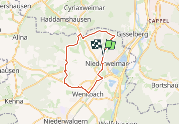
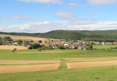
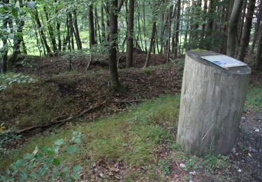
Ruta A pie de 10,1 km a descubrir en Hesse, Landkreis Marburg-Biedenkopf, Weimar (Lahn). Esta ruta ha sido propuesta por SityTrail - itinéraires balisés pédestres.
Trail created by Gemeinde Weimar (Lahn).
Symbol: Gelber Text "W6" auf schwarzem Hintergrund
![Excursión A pie Weimar (Lahn) - [W6] Ortsrundweg Niederweimar - Oberweimar - Niederweimar - Photo 1](https://media.geolcdn.com/t/2048/auto/2a49d6df-fc17-4cd4-9f80-78f8a08c964c.jpeg&format=jpg&maxdim=0 "Excursión A pie Weimar (Lahn) - [W6] Ortsrundweg Niederweimar - Oberweimar - Niederweimar - Photo 1")
![Excursión A pie Weimar (Lahn) - [W6] Ortsrundweg Niederweimar - Oberweimar - Niederweimar - Photo 2](https://media.geolcdn.com/t/2048/auto/439f049c-a7f2-4684-bcf6-be49d5d48d67.jpeg&format=jpg&maxdim=0 "Excursión A pie Weimar (Lahn) - [W6] Ortsrundweg Niederweimar - Oberweimar - Niederweimar - Photo 2")
![Excursión A pie Weimar (Lahn) - [W6] Ortsrundweg Niederweimar - Oberweimar - Niederweimar - Photo 3](https://media.geolcdn.com/t/2048/auto/618cc157-674d-46e7-ae0c-c112bcd39e3c.jpeg&format=jpg&maxdim=0 "Excursión A pie Weimar (Lahn) - [W6] Ortsrundweg Niederweimar - Oberweimar - Niederweimar - Photo 3")
![Excursión A pie Weimar (Lahn) - [W6] Ortsrundweg Niederweimar - Oberweimar - Niederweimar - Photo 4](https://media.geolcdn.com/t/2048/auto/0e51b98c-f652-4e63-a7d9-2373be081644.jpeg&format=jpg&maxdim=0 "Excursión A pie Weimar (Lahn) - [W6] Ortsrundweg Niederweimar - Oberweimar - Niederweimar - Photo 4")
![Excursión A pie Weimar (Lahn) - [W6] Ortsrundweg Niederweimar - Oberweimar - Niederweimar - Photo 5](https://media.geolcdn.com/t/2048/auto/65fbafd8-793d-4843-b991-ba9668cc990d.jpeg&format=jpg&maxdim=0 "Excursión A pie Weimar (Lahn) - [W6] Ortsrundweg Niederweimar - Oberweimar - Niederweimar - Photo 5")
![Excursión A pie Weimar (Lahn) - [W6] Ortsrundweg Niederweimar - Oberweimar - Niederweimar - Photo 6](https://media.geolcdn.com/t/2048/auto/7bba7303-a04f-4fe2-bafc-8dee22120f18.jpeg&format=jpg&maxdim=0 "Excursión A pie Weimar (Lahn) - [W6] Ortsrundweg Niederweimar - Oberweimar - Niederweimar - Photo 6")
![Excursión A pie Weimar (Lahn) - [W6] Ortsrundweg Niederweimar - Oberweimar - Niederweimar - Photo 7](https://media.geolcdn.com/t/2048/auto/a61a317a-bd39-4a7b-8404-9db451414bfb.jpeg&format=jpg&maxdim=0 "Excursión A pie Weimar (Lahn) - [W6] Ortsrundweg Niederweimar - Oberweimar - Niederweimar - Photo 7")
![Excursión A pie Weimar (Lahn) - [W6] Ortsrundweg Niederweimar - Oberweimar - Niederweimar - Photo 8](https://media.geolcdn.com/t/2048/auto/3bc795d5-8ccb-48ab-b7f6-fe7f27730326.jpeg&format=jpg&maxdim=0 "Excursión A pie Weimar (Lahn) - [W6] Ortsrundweg Niederweimar - Oberweimar - Niederweimar - Photo 8")
![Excursión A pie Weimar (Lahn) - [W6] Ortsrundweg Niederweimar - Oberweimar - Niederweimar - Photo 9](https://media.geolcdn.com/t/2048/auto/5315a4e8-56d7-4a23-9b53-67ad8b3b0bac.jpeg&format=jpg&maxdim=0 "Excursión A pie Weimar (Lahn) - [W6] Ortsrundweg Niederweimar - Oberweimar - Niederweimar - Photo 9")
![Excursión A pie Weimar (Lahn) - [W6] Ortsrundweg Niederweimar - Oberweimar - Niederweimar - Photo 10](https://media.geolcdn.com/t/2048/auto/a2e9735c-69f5-4b96-aa98-45b385787d95.jpeg&format=jpg&maxdim=0 "Excursión A pie Weimar (Lahn) - [W6] Ortsrundweg Niederweimar - Oberweimar - Niederweimar - Photo 10")
A pie
A pie
A pie
A pie
A pie
![Excursión A pie Marburg - [B2] - Wanderweg des Verkehrs- und Verschönerungsvereins Marburg - Photo](https://media.geolcdn.com/t/375/260/4766ed96-9908-434d-ab4b-2aef3b8e03f3.jpeg&format=jpg&maxdim=2)
A pie
![Excursión A pie Marburg - [D3] Rundwanderweg Stadtwald Niederweimar - Photo](https://media.geolcdn.com/t/375/260/5315a4e8-56d7-4a23-9b53-67ad8b3b0bac.jpeg&format=jpg&maxdim=2)
A pie
![Excursión A pie Marburg - [D6] Rundwanderweg Rumpeltal - Photo](https://media.geolcdn.com/t/375/260/f5b1abdc-c4ab-41bf-89af-120541dea1b9.jpeg&format=jpg&maxdim=2)
A pie
A pie