


22 km | 29 km-effort
![Excursión A pie Desconocido - [-] Höhenweg Wehringhausen - Herdecke - Photo](https://media.geolcdn.com/t/1900/400/4387e361-0797-400d-87e7-45695bb9bdc7.jpeg&format=pjpeg&maxdim=2)

Tous les sentiers balisés d’Europe GUIDE+


Aplicación GPS de excursión GRATIS
 SityTrail
IGN / Institutos geográficos
SityTrail World
El mundo es suyo
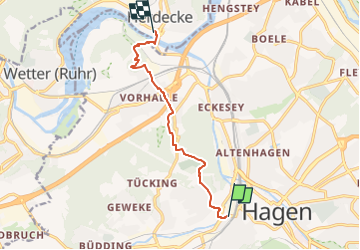
Ruta A pie de 7,3 km a descubrir en Renania del Norte-Westfalia, Hagen, Desconocido. Esta ruta ha sido propuesta por SityTrail - itinéraires balisés pédestres.
Trail created by Sauerländischer Gebirgsverein.
Symbol: weißer Balken auf schwarzem Grund
![Excursión A pie Desconocido - [-] Höhenweg Wehringhausen - Herdecke - Photo 1](https://media.geolcdn.com/t/2048/auto/6c2bd3ae-939c-4e3f-8280-eee582a0436d.jpeg&format=jpg&maxdim=0 "Excursión A pie Desconocido - [-] Höhenweg Wehringhausen - Herdecke - Photo 1")
![Excursión A pie Desconocido - [-] Höhenweg Wehringhausen - Herdecke - Photo 2](https://media.geolcdn.com/t/2048/auto/76577fd6-5349-4255-946c-346f39401aeb.jpeg&format=jpg&maxdim=0 "Excursión A pie Desconocido - [-] Höhenweg Wehringhausen - Herdecke - Photo 2")
![Excursión A pie Desconocido - [-] Höhenweg Wehringhausen - Herdecke - Photo 3](https://media.geolcdn.com/t/2048/auto/4bdef6e9-ad44-41e2-982f-ff58ec2c8850.jpeg&format=jpg&maxdim=0 "Excursión A pie Desconocido - [-] Höhenweg Wehringhausen - Herdecke - Photo 3")
![Excursión A pie Desconocido - [-] Höhenweg Wehringhausen - Herdecke - Photo 4](https://media.geolcdn.com/t/2048/auto/f097e268-88ca-4d1e-bcb2-9f3a0fa45ff5.jpeg&format=jpg&maxdim=0 "Excursión A pie Desconocido - [-] Höhenweg Wehringhausen - Herdecke - Photo 4")
![Excursión A pie Desconocido - [-] Höhenweg Wehringhausen - Herdecke - Photo 5](https://media.geolcdn.com/t/2048/auto/2432c777-0194-43ac-aad3-35c8810e9b56.jpeg&format=jpg&maxdim=0 "Excursión A pie Desconocido - [-] Höhenweg Wehringhausen - Herdecke - Photo 5")
![Excursión A pie Desconocido - [-] Höhenweg Wehringhausen - Herdecke - Photo 6](https://media.geolcdn.com/t/2048/auto/9e26fe4e-ac4d-448a-a9d5-eb30bced0fb8.jpeg&format=jpg&maxdim=0 "Excursión A pie Desconocido - [-] Höhenweg Wehringhausen - Herdecke - Photo 6")
![Excursión A pie Desconocido - [-] Höhenweg Wehringhausen - Herdecke - Photo 7](https://media.geolcdn.com/t/2048/auto/ad51c935-627a-4df6-9c32-2adfe0fce5a1.jpeg&format=jpg&maxdim=0 "Excursión A pie Desconocido - [-] Höhenweg Wehringhausen - Herdecke - Photo 7")
![Excursión A pie Desconocido - [-] Höhenweg Wehringhausen - Herdecke - Photo 8](https://media.geolcdn.com/t/2048/auto/4387e361-0797-400d-87e7-45695bb9bdc7.jpeg&format=jpg&maxdim=0 "Excursión A pie Desconocido - [-] Höhenweg Wehringhausen - Herdecke - Photo 8")
![Excursión A pie Desconocido - [-] Höhenweg Wehringhausen - Herdecke - Photo 9](https://media.geolcdn.com/t/2048/auto/577b6bf2-5548-4053-9f88-7131355c9cb0.jpeg&format=jpg&maxdim=0 "Excursión A pie Desconocido - [-] Höhenweg Wehringhausen - Herdecke - Photo 9")
![Excursión A pie Desconocido - [-] Höhenweg Wehringhausen - Herdecke - Photo 10](https://media.geolcdn.com/t/2048/auto/1a148d1c-95e2-43ed-bee8-bb698ccdc6b4.jpeg&format=jpg&maxdim=0 "Excursión A pie Desconocido - [-] Höhenweg Wehringhausen - Herdecke - Photo 10")
![Excursión A pie Herdecke - [H6] Waldgebiete - Photo](https://media.geolcdn.com/t/375/260/fc184e54-a300-4080-bfb1-ee5af7544b8a.jpeg&format=jpg&maxdim=2)
A pie
![Excursión A pie Herdecke - [H5] Westende - Kirchende - Ostende - Photo](https://media.geolcdn.com/t/375/260/a4190d68-4b9d-4b0c-86e3-91419be4a223.jpeg&format=jpg&maxdim=2)
A pie
![Excursión A pie Herdecke - [H2] Ruhrtal zum Hickenstein - Photo](https://media.geolcdn.com/t/375/260/47dfa9a4-572d-4f34-b111-ae10e112c377.jpeg&format=jpg&maxdim=2)
A pie
![Excursión A pie Herdecke - [H1] Viadukt und Nacken - Photo](https://media.geolcdn.com/t/375/260/0816fcff-a194-4a3a-b211-f59c276124fc.jpeg&format=jpg&maxdim=2)
A pie

A pie
A pie
A pie
A pie
A pie