![](/images/other/stat-length.png)
![Excursión A pie Desconocido - Dreieck Hasper Talsperre - Photo](https://media.geolcdn.com/t/1900/400/ext.pjpeg?maxdim=2&url=https%3A%2F%2Fstatic1.geolcdn.com%2Fsiteimages%2Fupload%2Ffiles%2F1545311037marcheuse_200dpi.jpg)
Dreieck Hasper Talsperre
SityTrail - itinéraires balisés pédestres
Tous les sentiers balisés d’Europe PRO
![Longitud](/images/other/stat-length.png)
Longitud
5,3 km
![Altitud máxima](https://static1.geolcdn.com/siteimages/upload/files/1508320355ic_sort_altitude_max_24dp.png)
Altitud máxima
389 m
![Desnivel positivo](https://static1.geolcdn.com/siteimages/upload/files/1508320355ic_sort_den_pos_24dp.png)
Desnivel positivo
136 m
![Km-Effort](/images/other/stat-length.png)
Km-Effort
7,4 km
![Altitud mínima](https://static1.geolcdn.com/siteimages/upload/files/1508320355ic_sort_altitude_min_24dp.png)
Altitud mínima
165 m
![Desnivel negativo](https://static1.geolcdn.com/siteimages/upload/files/1508320355ic_sort_den_neg_24dp.png)
Desnivel negativo
228 m
![Boucle](https://static1.geolcdn.com/siteimages/upload/files/16400158638029165_repeat_loop_refresh_sync_direction_icon.png)
Boucle
No
Baliza
Fecha de creación :
2022-02-11 15:14:45.103
Última modificación :
2022-02-11 15:14:45.103
![A pie](https://static1.geolcdn.com/sitytour/trail-icons/100.png)
1h41
Dificultad : Fácil
![Escanee este código QR para abrir la excursión en la aplicación SityTrail](https://capi.geolives.com/qq0zvz2zws4bq2lad0pu/sitytour/trails/3094139/qr.png?size=200)
Aplicación GPS de excursión GRATIS
A propósito
Ruta A pie de 5,3 km a descubrir en Renania del Norte-Westfalia, Hagen, Desconocido. Esta ruta ha sido propuesta por SityTrail - itinéraires balisés pédestres.
Descripción
Trail created by Sauerländischer Gebirgsverein.
Symbol: weißes Dreieck
Localización
País:
Germany
Región :
Renania del Norte-Westfalia
Departamento/provincia :
Hagen
Municipio :
Desconocido
Localidad:
Haspe
Salida:(Dec)
Salida:(UTM)
388806 ; 5684442 (32U) N.
Comentarios
Excursiones cerca
![Excursión A pie Ennepetal - GEV-Nirgena - EN-Voerde - EN-Ahlhausen - Photo](https://media.geolcdn.com/t/375/260/ext.jpg?maxdim=2&url=https%3A%2F%2Fmedia.geolcdn.com%2Ff%2Fda141f89-6e3f-4d71-b3a3-70cff173877e.jpeg)
![A pie A pie](https://static1.geolcdn.com/sitytour/trail-icons/100.png)
GEV-Nirgena - EN-Voerde - EN-Ahlhausen
A pie
Fácil
Ennepetal,
Renania del Norte-Westfalia,
Ennepe-Ruhr-Kreis,
Germany
![](/images/other/stat-length.png)
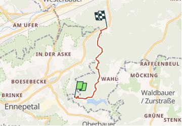
10,4 km | 14,3 km-effort
3h 15min
![](https://static1.geolcdn.com/siteimages/upload/files/16400158638029165_repeat_loop_refresh_sync_direction_icon.png)
No
![Excursión A pie Gevelsberg - Gevelsberg A2 - Photo](https://media.geolcdn.com/t/375/260/ext.jpg?maxdim=2&url=https%3A%2F%2Fmedia.geolcdn.com%2Ff%2F21da2367-fb27-4e94-9be3-4f8ac0f58149.jpeg)
![A pie A pie](https://static1.geolcdn.com/sitytour/trail-icons/100.png)
Gevelsberg A2
A pie
Fácil
Gevelsberg,
Renania del Norte-Westfalia,
Ennepe-Ruhr-Kreis,
Germany
![](/images/other/stat-length.png)
5,4 km | 7,5 km-effort
1h 42min
![](https://static1.geolcdn.com/siteimages/upload/files/16400158638029165_repeat_loop_refresh_sync_direction_icon.png)
Sí
![Excursión A pie Breckerfeld - Rundwanderweg Breckerfeld (nach Zurstraße) A8 - Photo](https://media.geolcdn.com/t/375/260/ext.jpg?maxdim=2&url=https%3A%2F%2Fmedia.geolcdn.com%2Ff%2F91384308-df9e-4ec2-b5bd-6d78a4449bce.jpeg)
![A pie A pie](https://static1.geolcdn.com/sitytour/trail-icons/100.png)
Rundwanderweg Breckerfeld (nach Zurstraße) A8
A pie
Medio
Breckerfeld,
Renania del Norte-Westfalia,
Ennepe-Ruhr-Kreis,
Germany
![](/images/other/stat-length.png)
17,3 km | 23 km-effort
5h 16min
![](https://static1.geolcdn.com/siteimages/upload/files/16400158638029165_repeat_loop_refresh_sync_direction_icon.png)
Sí
![Excursión A pie Breckerfeld - Rundweg Breckerfeld über Brenscheid A15 - Photo](https://media.geolcdn.com/t/375/260/ext.jpg?maxdim=2&url=https%3A%2F%2Fmedia.geolcdn.com%2Ff%2F91384308-df9e-4ec2-b5bd-6d78a4449bce.jpeg)
![A pie A pie](https://static1.geolcdn.com/sitytour/trail-icons/100.png)
Rundweg Breckerfeld über Brenscheid A15
A pie
Medio
Breckerfeld,
Renania del Norte-Westfalia,
Ennepe-Ruhr-Kreis,
Germany
![](/images/other/stat-length.png)
15,5 km | 20 km-effort
4h 35min
![](https://static1.geolcdn.com/siteimages/upload/files/16400158638029165_repeat_loop_refresh_sync_direction_icon.png)
Sí
![Excursión A pie Breckerfeld - [A10]Rundweg Breckerfeld (zur Glörtalsperre) - Photo](https://media.geolcdn.com/t/375/260/ext.jpg?maxdim=2&url=https%3A%2F%2Fmedia.geolcdn.com%2Ff%2F497900ac-296a-4d0b-bf58-8b261fe038d7.jpeg)
![A pie A pie](https://static1.geolcdn.com/sitytour/trail-icons/100.png)
[A10]Rundweg Breckerfeld (zur Glörtalsperre)
A pie
Fácil
Breckerfeld,
Renania del Norte-Westfalia,
Ennepe-Ruhr-Kreis,
Germany
![](/images/other/stat-length.png)
13,3 km | 17,6 km-effort
4h 0min
![](https://static1.geolcdn.com/siteimages/upload/files/16400158638029165_repeat_loop_refresh_sync_direction_icon.png)
Sí
![Excursión A pie Desconocido - Hohensteinweg - Photo](https://media.geolcdn.com/t/375/260/ext.jpg?maxdim=2&url=https%3A%2F%2Fmedia.geolcdn.com%2Ff%2Fbb733b20-9134-4075-8548-696dce4a3fea.jpeg)
![A pie A pie](https://static1.geolcdn.com/sitytour/trail-icons/100.png)
Hohensteinweg
A pie
Fácil
Desconocido,
Renania del Norte-Westfalia,
Hagen,
Germany
![](/images/other/stat-length.png)
11,5 km | 16,2 km-effort
3h 40min
![](https://static1.geolcdn.com/siteimages/upload/files/16400158638029165_repeat_loop_refresh_sync_direction_icon.png)
No
![Excursión A pie Ennepetal - Voerde Rundweg A7 - Photo](https://media.geolcdn.com/t/375/260/ext.jpg?maxdim=2&url=https%3A%2F%2Fmedia.geolcdn.com%2Ff%2F06f812dd-828f-4932-abc8-6edb7058f4bf.jpeg)
![A pie A pie](https://static1.geolcdn.com/sitytour/trail-icons/100.png)
Voerde Rundweg A7
A pie
Fácil
Ennepetal,
Renania del Norte-Westfalia,
Ennepe-Ruhr-Kreis,
Germany
![](/images/other/stat-length.png)
5,2 km | 6,8 km-effort
1h 33min
![](https://static1.geolcdn.com/siteimages/upload/files/16400158638029165_repeat_loop_refresh_sync_direction_icon.png)
No
![Excursión A pie Desconocido - Drei-Türme-Weg - Photo](https://media.geolcdn.com/t/375/260/ext.jpg?maxdim=2&url=https%3A%2F%2Fmedia.geolcdn.com%2Ff%2F836594e2-4f78-4366-a0e0-33994641110a.jpeg)
![A pie A pie](https://static1.geolcdn.com/sitytour/trail-icons/100.png)
Drei-Türme-Weg
A pie
Fácil
Desconocido,
Renania del Norte-Westfalia,
Hagen,
Germany
![](/images/other/stat-length.png)
7 km | 9,6 km-effort
2h 10min
![](https://static1.geolcdn.com/siteimages/upload/files/16400158638029165_repeat_loop_refresh_sync_direction_icon.png)
No
![Excursión A pie Gevelsberg - Wanderweg Gevelsberg-Silschede - Photo](https://media.geolcdn.com/t/375/260/ext.jpg?maxdim=2&url=https%3A%2F%2Fmedia.geolcdn.com%2Ff%2Fe8511c04-2680-4359-a7af-e8f515133e2a.jpeg)
![A pie A pie](https://static1.geolcdn.com/sitytour/trail-icons/100.png)
Wanderweg Gevelsberg-Silschede
A pie
Fácil
Gevelsberg,
Renania del Norte-Westfalia,
Ennepe-Ruhr-Kreis,
Germany
![](/images/other/stat-length.png)
11,5 km | 14,7 km-effort
3h 20min
![](https://static1.geolcdn.com/siteimages/upload/files/16400158638029165_repeat_loop_refresh_sync_direction_icon.png)
No