![](/images/other/stat-length.png)
![Excursión A pie Drolshagen - Drolshagen Rundweg A9 (Stadtpark Lohmühle) - Photo](https://media.geolcdn.com/t/1900/400/ext.pjpeg?maxdim=2&url=https%3A%2F%2Fstatic1.geolcdn.com%2Fsiteimages%2Fupload%2Ffiles%2F1545311037marcheuse_200dpi.jpg)
Drolshagen Rundweg A9 (Stadtpark Lohmühle)
SityTrail - itinéraires balisés pédestres
Tous les sentiers balisés d’Europe PRO
![Longitud](/images/other/stat-length.png)
Longitud
10,7 km
![Altitud máxima](https://static1.geolcdn.com/siteimages/upload/files/1508320355ic_sort_altitude_max_24dp.png)
Altitud máxima
505 m
![Desnivel positivo](https://static1.geolcdn.com/siteimages/upload/files/1508320355ic_sort_den_pos_24dp.png)
Desnivel positivo
282 m
![Km-Effort](/images/other/stat-length.png)
Km-Effort
14,4 km
![Altitud mínima](https://static1.geolcdn.com/siteimages/upload/files/1508320355ic_sort_altitude_min_24dp.png)
Altitud mínima
352 m
![Desnivel negativo](https://static1.geolcdn.com/siteimages/upload/files/1508320355ic_sort_den_neg_24dp.png)
Desnivel negativo
279 m
![Boucle](https://static1.geolcdn.com/siteimages/upload/files/16400158638029165_repeat_loop_refresh_sync_direction_icon.png)
Boucle
Sí
Baliza
Fecha de creación :
2022-02-11 14:48:45.488
Última modificación :
2022-02-11 14:48:45.488
![A pie](https://static1.geolcdn.com/sitytour/trail-icons/100.png)
3h16
Dificultad : Fácil
![Escanee este código QR para abrir la excursión en la aplicación SityTrail](https://capi.geolives.com/qq0zvz2zws4bq2lad0pu/sitytour/trails/3093370/qr.png?size=200)
Aplicación GPS de excursión GRATIS
A propósito
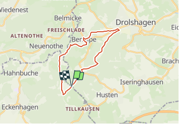
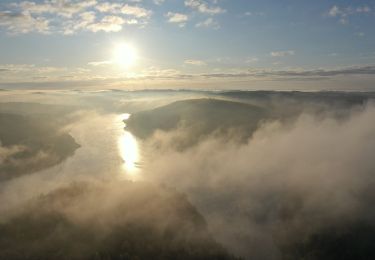
Ruta A pie de 10,7 km a descubrir en Renania del Norte-Westfalia, Kreis Olpe, Drolshagen. Esta ruta ha sido propuesta por SityTrail - itinéraires balisés pédestres.
Descripción
Trail created by Sauerländischer Gebirgsverein.
Localización
País:
Germany
Región :
Renania del Norte-Westfalia
Departamento/provincia :
Kreis Olpe
Municipio :
Drolshagen
Localidad:
Unknown
Salida:(Dec)
Salida:(UTM)
410865 ; 5650142 (32U) N.
Comentarios
Excursiones cerca
![Excursión A pie Drolshagen - Zeichen-Kurs Drolshagen - Photo](https://media.geolcdn.com/t/375/260/ext.jpg?maxdim=2&url=https%3A%2F%2Fmedia.geolcdn.com%2Ff%2F662d9b47-ca62-40d1-8307-0cbe52a41456.jpeg)
![A pie A pie](https://static1.geolcdn.com/sitytour/trail-icons/100.png)
Zeichen-Kurs Drolshagen
A pie
Fácil
Drolshagen,
Renania del Norte-Westfalia,
Kreis Olpe,
Germany
![](/images/other/stat-length.png)
4,4 km | 5,8 km-effort
1h 19min
![](https://static1.geolcdn.com/siteimages/upload/files/16400158638029165_repeat_loop_refresh_sync_direction_icon.png)
Sí
![Excursión A pie Drolshagen - Drolshagen Rundweg A1 (Hützemert) - Photo](https://media.geolcdn.com/t/375/260/ext.jpg?maxdim=2&url=https%3A%2F%2Fmedia.geolcdn.com%2Ff%2Ffbb43658-a3b7-4928-8287-e2537ba7274f.jpeg)
![A pie A pie](https://static1.geolcdn.com/sitytour/trail-icons/100.png)
Drolshagen Rundweg A1 (Hützemert)
A pie
Fácil
Drolshagen,
Renania del Norte-Westfalia,
Kreis Olpe,
Germany
![](/images/other/stat-length.png)
6,9 km | 9 km-effort
2h 2min
![](https://static1.geolcdn.com/siteimages/upload/files/16400158638029165_repeat_loop_refresh_sync_direction_icon.png)
Sí
![Excursión A pie Reichshof - [12] Wacholderweg Eckenhagen - Photo](https://media.geolcdn.com/t/375/260/ext.jpg?maxdim=2&url=https%3A%2F%2Fmedia.geolcdn.com%2Ff%2F9032ef15-8ba3-440e-8561-25cdda2b27c1.jpeg)
![A pie A pie](https://static1.geolcdn.com/sitytour/trail-icons/100.png)
[12] Wacholderweg Eckenhagen
A pie
Fácil
Reichshof,
Renania del Norte-Westfalia,
Oberbergischer Kreis,
Germany
![](/images/other/stat-length.png)
5,4 km | 7,5 km-effort
1h 42min
![](https://static1.geolcdn.com/siteimages/upload/files/16400158638029165_repeat_loop_refresh_sync_direction_icon.png)
Sí
![Excursión A pie Drolshagen - Drolshagen Rundweg A8 (Brudertreue) - Photo](https://media.geolcdn.com/t/375/260/ext.jpg?maxdim=2&url=https%3A%2F%2Fmedia.geolcdn.com%2Ff%2Fb32e03d5-d6b6-487e-a893-ee577e03489f.jpeg)
![A pie A pie](https://static1.geolcdn.com/sitytour/trail-icons/100.png)
Drolshagen Rundweg A8 (Brudertreue)
A pie
Fácil
Drolshagen,
Renania del Norte-Westfalia,
Kreis Olpe,
Germany
![](/images/other/stat-length.png)
7,3 km | 10,2 km-effort
2h 18min
![](https://static1.geolcdn.com/siteimages/upload/files/16400158638029165_repeat_loop_refresh_sync_direction_icon.png)
Sí
![Excursión A pie Drolshagen - Drolshagen Rundweg A7 (Husten) - Photo](https://media.geolcdn.com/t/375/260/ext.jpg?maxdim=2&url=https%3A%2F%2Fstatic1.geolcdn.com%2Fsiteimages%2Fupload%2Ffiles%2F1545311037marcheuse_200dpi.jpg)
![A pie A pie](https://static1.geolcdn.com/sitytour/trail-icons/100.png)
Drolshagen Rundweg A7 (Husten)
A pie
Fácil
Drolshagen,
Renania del Norte-Westfalia,
Kreis Olpe,
Germany
![](/images/other/stat-length.png)
6,2 km | 8 km-effort
1h 49min
![](https://static1.geolcdn.com/siteimages/upload/files/16400158638029165_repeat_loop_refresh_sync_direction_icon.png)
No
![Excursión A pie Reichshof - Heischeid Rundweg A1 - Photo](https://media.geolcdn.com/t/375/260/ext.jpg?maxdim=2&url=https%3A%2F%2Fmedia.geolcdn.com%2Ff%2F6641a6fe-09fd-428f-9632-ee550a68e50e.jpeg)
![A pie A pie](https://static1.geolcdn.com/sitytour/trail-icons/100.png)
Heischeid Rundweg A1
A pie
Fácil
Reichshof,
Renania del Norte-Westfalia,
Oberbergischer Kreis,
Germany
![](/images/other/stat-length.png)
5,8 km | 7,3 km-effort
1h 39min
![](https://static1.geolcdn.com/siteimages/upload/files/16400158638029165_repeat_loop_refresh_sync_direction_icon.png)
Sí
![Excursión A pie Reichshof - Rundweg A2 - Photo](https://media.geolcdn.com/t/375/260/ext.jpg?maxdim=2&url=https%3A%2F%2Fstatic1.geolcdn.com%2Fsiteimages%2Fupload%2Ffiles%2F1545311037marcheuse_200dpi.jpg)
![A pie A pie](https://static1.geolcdn.com/sitytour/trail-icons/100.png)
Rundweg A2
A pie
Fácil
Reichshof,
Renania del Norte-Westfalia,
Oberbergischer Kreis,
Germany
![](/images/other/stat-length.png)
4,5 km | 6,5 km-effort
1h 29min
![](https://static1.geolcdn.com/siteimages/upload/files/16400158638029165_repeat_loop_refresh_sync_direction_icon.png)
Sí