![](/images/other/stat-length.png)
![Excursión A pie Bayrischzell - Wendelstein - Osterhofen (Seilbahn-Talstation) - Photo](https://media.geolcdn.com/t/1900/400/a89a9e76-e30d-42c1-a1ca-5e1b93d40c60.jpeg&format=pjpeg&maxdim=2)
Wendelstein - Osterhofen (Seilbahn-Talstation)
SityTrail - itinéraires balisés pédestres
Tous les sentiers balisés d’Europe GUIDE+
![Longitud](/images/other/stat-length.png)
Longitud
6,1 km
![Altitud máxima](https://static1.geolcdn.com/siteimages/upload/files/1508320355ic_sort_altitude_max_24dp.png)
Altitud máxima
1725 m
![Desnivel positivo](https://static1.geolcdn.com/siteimages/upload/files/1508320355ic_sort_den_pos_24dp.png)
Desnivel positivo
1 m
![Km-Effort](/images/other/stat-length.png)
Km-Effort
9,2 km
![Altitud mínima](https://static1.geolcdn.com/siteimages/upload/files/1508320355ic_sort_altitude_min_24dp.png)
Altitud mínima
788 m
![Desnivel negativo](https://static1.geolcdn.com/siteimages/upload/files/1508320355ic_sort_den_neg_24dp.png)
Desnivel negativo
928 m
![Boucle](https://static1.geolcdn.com/siteimages/upload/files/16400158638029165_repeat_loop_refresh_sync_direction_icon.png)
Boucle
No
Baliza
Fecha de creación :
2022-02-11 14:32:27.779
Última modificación :
2022-02-11 14:32:27.779
![A pie](https://static1.geolcdn.com/sitytour/trail-icons/100.png)
2h05
Dificultad : Fácil
![Escanee este código QR para abrir la excursión en la aplicación SityTrail](https://capi.geolives.com/qq0zvz2zws4bq2lad0pu/sitytour/trails/3092788/qr.png?size=200)
Aplicación GPS de excursión GRATIS
A propósito
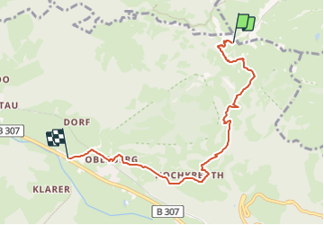
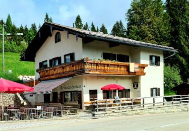
Ruta A pie de 6,1 km a descubrir en Baviera, Landkreis Miesbach, Bayrischzell. Esta ruta ha sido propuesta por SityTrail - itinéraires balisés pédestres.
Descripción
Trail created by Wendelsteinbahn GmbH.
Symbol: Weißes W umrundet von einem weißen Kreis auf blauem Hintergrund
Localización
País:
Germany
Región :
Baviera
Departamento/provincia :
Landkreis Miesbach
Municipio :
Bayrischzell
Localidad:
Unknown
Salida:(Dec)
Salida:(UTM)
275852 ; 5287531 (33T) N.
Comentarios
Excursiones cerca
![Excursión A pie Bayrischzell - Sparkasse - Trail - Mieseben-Runde - Photo](https://media.geolcdn.com/t/375/260/bf078132-00f4-4233-9faa-ea3a148c09c2.jpeg&format=jpg&maxdim=2)
![A pie A pie](https://static1.geolcdn.com/sitytour/trail-icons/100.png)
Sparkasse - Trail - Mieseben-Runde
A pie
Fácil
Bayrischzell,
Baviera,
Landkreis Miesbach,
Germany
![](/images/other/stat-length.png)
6,4 km | 8 km-effort
1h 49min
![](https://static1.geolcdn.com/siteimages/upload/files/16400158638029165_repeat_loop_refresh_sync_direction_icon.png)
Sí
![Excursión A pie Fischbachau - Steingrabner - Alm - Wirtsalm - Bad Feilnbach - Photo](https://media.geolcdn.com/t/375/260/f3ffc65e-38c1-4155-aa30-502888f8fa23.jpeg&format=jpg&maxdim=2)
![A pie A pie](https://static1.geolcdn.com/sitytour/trail-icons/100.png)
Steingrabner - Alm - Wirtsalm - Bad Feilnbach
A pie
Fácil
Fischbachau,
Baviera,
Landkreis Miesbach,
Germany
![](/images/other/stat-length.png)
3 km | 5,9 km-effort
1h 20min
![](https://static1.geolcdn.com/siteimages/upload/files/16400158638029165_repeat_loop_refresh_sync_direction_icon.png)
No
![Excursión A pie Fischbachau - Wanderweg 591 - Elbach - Bad Feilnbach - Photo](https://media.geolcdn.com/t/375/260/1a4d196f-e635-4969-b474-b60408591323.jpeg&format=jpg&maxdim=2)
![A pie A pie](https://static1.geolcdn.com/sitytour/trail-icons/100.png)
Wanderweg 591 - Elbach - Bad Feilnbach
A pie
Fácil
Fischbachau,
Baviera,
Landkreis Miesbach,
Germany
![](/images/other/stat-length.png)
10,3 km | 13,7 km-effort
3h 7min
![](https://static1.geolcdn.com/siteimages/upload/files/16400158638029165_repeat_loop_refresh_sync_direction_icon.png)
No
![Excursión A pie Brannenburg - BF6 - Über Stock und Stein - Photo](https://media.geolcdn.com/t/375/260/2a30d4b6-0465-48d6-8cc0-41f81cd4d999.jpeg&format=jpg&maxdim=2)
![A pie A pie](https://static1.geolcdn.com/sitytour/trail-icons/100.png)
BF6 - Über Stock und Stein
A pie
Medio
Brannenburg,
Baviera,
Landkreis Rosenheim,
Germany
![](/images/other/stat-length.png)
16 km | 27 km-effort
6h 4min
![](https://static1.geolcdn.com/siteimages/upload/files/16400158638029165_repeat_loop_refresh_sync_direction_icon.png)
Sí
![Excursión A pie Bayrischzell - Wanderweg B1 - Wendelsteinalmen - Photo](https://media.geolcdn.com/t/375/260/11c5ccf2-4fcd-4acc-bb8b-a0903122ac6d.jpeg&format=jpg&maxdim=2)
![A pie A pie](https://static1.geolcdn.com/sitytour/trail-icons/100.png)
Wanderweg B1 - Wendelsteinalmen
A pie
Fácil
Bayrischzell,
Baviera,
Landkreis Miesbach,
Germany
![](/images/other/stat-length.png)
3,1 km | 9 km-effort
2h 2min
![](https://static1.geolcdn.com/siteimages/upload/files/16400158638029165_repeat_loop_refresh_sync_direction_icon.png)
No
![Excursión A pie - Wanderweg 660 - Bayrischzell - Wendelstein - Photo](https://media.geolcdn.com/t/375/260/11c5ccf2-4fcd-4acc-bb8b-a0903122ac6d.jpeg&format=jpg&maxdim=2)
![A pie A pie](https://static1.geolcdn.com/sitytour/trail-icons/100.png)
Wanderweg 660 - Bayrischzell - Wendelstein
A pie
Fácil
,
Baviera,
Landkreis Miesbach,
Germany
![](/images/other/stat-length.png)
4,9 km | 14,1 km-effort
3h 11min
![](https://static1.geolcdn.com/siteimages/upload/files/16400158638029165_repeat_loop_refresh_sync_direction_icon.png)
No
![Excursión A pie - HAAS - Trail - Photo](https://media.geolcdn.com/t/375/260/11c5ccf2-4fcd-4acc-bb8b-a0903122ac6d.jpeg&format=jpg&maxdim=2)
![A pie A pie](https://static1.geolcdn.com/sitytour/trail-icons/100.png)
![Excursión A pie Oberaudorf - Wanderweg 662 - Unteres Sudelfeld - Wildalpjoch - Photo](https://media.geolcdn.com/t/375/260/578172b1-8eb3-451b-8673-4ad7da50e403.jpeg&format=jpg&maxdim=2)
![A pie A pie](https://static1.geolcdn.com/sitytour/trail-icons/100.png)
Wanderweg 662 - Unteres Sudelfeld - Wildalpjoch
A pie
Fácil
Oberaudorf,
Baviera,
Landkreis Rosenheim,
Germany
![](/images/other/stat-length.png)
4,5 km | 10,8 km-effort
2h 27min
![](https://static1.geolcdn.com/siteimages/upload/files/16400158638029165_repeat_loop_refresh_sync_direction_icon.png)
No
![Excursión A pie Bayrischzell - Wendelstein - Sudelfeld Passhöhe - Photo](https://media.geolcdn.com/t/375/260/2ee704db-3ce7-4213-9156-31e387f0ac63.jpeg&format=jpg&maxdim=2)
![A pie A pie](https://static1.geolcdn.com/sitytour/trail-icons/100.png)
Wendelstein - Sudelfeld Passhöhe
A pie
Fácil
Bayrischzell,
Baviera,
Landkreis Miesbach,
Germany
![](/images/other/stat-length.png)
4,8 km | 7,3 km-effort
1h 39min
![](https://static1.geolcdn.com/siteimages/upload/files/16400158638029165_repeat_loop_refresh_sync_direction_icon.png)
No