![](/images/other/stat-length.png)
![Excursión A pie Reinheim - Ortsrundwanderweg Reinheim 3 - Photo](https://media.geolcdn.com/t/1900/400/79bc8891-60a4-45ea-8da4-c409d8dd127f.jpeg&format=pjpeg&maxdim=2)
Ortsrundwanderweg Reinheim 3
SityTrail - itinéraires balisés pédestres
Tous les sentiers balisés d’Europe GUIDE+
![Longitud](/images/other/stat-length.png)
Longitud
3,3 km
![Altitud máxima](https://static1.geolcdn.com/siteimages/upload/files/1508320355ic_sort_altitude_max_24dp.png)
Altitud máxima
191 m
![Desnivel positivo](https://static1.geolcdn.com/siteimages/upload/files/1508320355ic_sort_den_pos_24dp.png)
Desnivel positivo
37 m
![Km-Effort](/images/other/stat-length.png)
Km-Effort
3,7 km
![Altitud mínima](https://static1.geolcdn.com/siteimages/upload/files/1508320355ic_sort_altitude_min_24dp.png)
Altitud mínima
162 m
![Desnivel negativo](https://static1.geolcdn.com/siteimages/upload/files/1508320355ic_sort_den_neg_24dp.png)
Desnivel negativo
23 m
![Boucle](https://static1.geolcdn.com/siteimages/upload/files/16400158638029165_repeat_loop_refresh_sync_direction_icon.png)
Boucle
No
Baliza
Fecha de creación :
2022-02-11 14:23:17.885
Última modificación :
2022-02-11 14:23:17.885
![A pie](https://static1.geolcdn.com/sitytour/trail-icons/100.png)
50m
Dificultad : Fácil
![Escanee este código QR para abrir la excursión en la aplicación SityTrail](https://capi.geolives.com/qq0zvz2zws4bq2lad0pu/sitytour/trails/3092552/qr.png?size=200)
Aplicación GPS de excursión GRATIS
A propósito
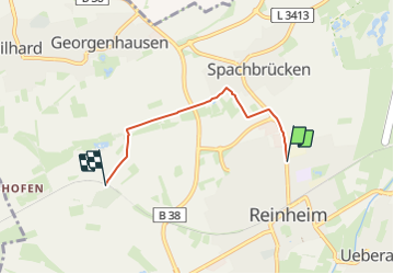
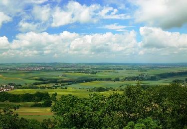
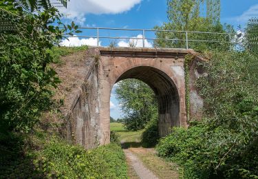
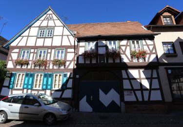
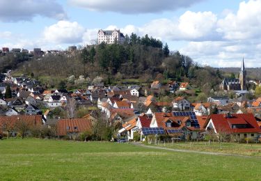
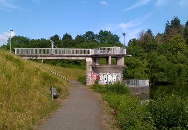
Ruta A pie de 3,3 km a descubrir en Hesse, Landkreis Darmstadt-Dieburg, Reinheim. Esta ruta ha sido propuesta por SityTrail - itinéraires balisés pédestres.
Descripción
Trail created by Geo-Naturpark Bergstraße-Odenwald.
Symbol: white 3 in a white circle with R in a break at the top of the circle
Localización
País:
Germany
Región :
Hesse
Departamento/provincia :
Landkreis Darmstadt-Dieburg
Municipio :
Reinheim
Localidad:
Unknown
Salida:(Dec)
Salida:(UTM)
488036 ; 5520117 (32U) N.
Comentarios
Excursiones cerca
![Excursión A pie Otzberg - Rundwanderweg Habitzheim 1 : Taubensemd-Weg - Photo](https://media.geolcdn.com/t/375/260/0f07252f-801e-4079-b89a-e2adc968e0ec.jpeg&format=jpg&maxdim=2)
![A pie A pie](https://static1.geolcdn.com/sitytour/trail-icons/100.png)
Rundwanderweg Habitzheim 1 : Taubensemd-Weg
A pie
Fácil
Otzberg,
Hesse,
Landkreis Darmstadt-Dieburg,
Germany
![](/images/other/stat-length.png)
8,4 km | 9,3 km-effort
2h 6min
![](https://static1.geolcdn.com/siteimages/upload/files/16400158638029165_repeat_loop_refresh_sync_direction_icon.png)
Sí
![Excursión A pie Ober-Ramstadt - Rundwanderweg Geisenwald - Photo](https://media.geolcdn.com/t/375/260/20159f53-0e50-4216-b2e8-a19cc37a638a.jpeg&format=jpg&maxdim=2)
![A pie A pie](https://static1.geolcdn.com/sitytour/trail-icons/100.png)
Rundwanderweg Geisenwald
A pie
Fácil
Ober-Ramstadt,
Hesse,
Landkreis Darmstadt-Dieburg,
Germany
![](/images/other/stat-length.png)
4,7 km | 6,5 km-effort
1h 28min
![](https://static1.geolcdn.com/siteimages/upload/files/16400158638029165_repeat_loop_refresh_sync_direction_icon.png)
Sí
![Excursión A pie Otzberg - Rundwanderweg Nieder-Klingen 1 : Otzberg-Weg - Photo](https://media.geolcdn.com/t/375/260/3287eab0-0506-4907-a6c1-c692c022d11f.jpeg&format=jpg&maxdim=2)
![A pie A pie](https://static1.geolcdn.com/sitytour/trail-icons/100.png)
Rundwanderweg Nieder-Klingen 1 : Otzberg-Weg
A pie
Fácil
Otzberg,
Hesse,
Landkreis Darmstadt-Dieburg,
Germany
![](/images/other/stat-length.png)
6,5 km | 8,5 km-effort
1h 55min
![](https://static1.geolcdn.com/siteimages/upload/files/16400158638029165_repeat_loop_refresh_sync_direction_icon.png)
Sí
![Excursión A pie Otzberg - Rundwanderweg Nieder-Klingen 2 : Ohmbuckel-Weg - Photo](https://media.geolcdn.com/t/375/260/ab97c964-5cbb-448d-9c1f-f0e32dc68c4d.jpeg&format=jpg&maxdim=2)
![A pie A pie](https://static1.geolcdn.com/sitytour/trail-icons/100.png)
Rundwanderweg Nieder-Klingen 2 : Ohmbuckel-Weg
A pie
Fácil
Otzberg,
Hesse,
Landkreis Darmstadt-Dieburg,
Germany
![](/images/other/stat-length.png)
11,7 km | 13 km-effort
2h 57min
![](https://static1.geolcdn.com/siteimages/upload/files/16400158638029165_repeat_loop_refresh_sync_direction_icon.png)
Sí
![Excursión A pie Reinheim - Ortsrundwanderweg S... 5 - Photo](https://media.geolcdn.com/t/375/260/277e98ec-bbee-4dd4-9717-b14c04abcbe4.jpeg&format=jpg&maxdim=2)
![A pie A pie](https://static1.geolcdn.com/sitytour/trail-icons/100.png)
Ortsrundwanderweg S... 5
A pie
Medio
Reinheim,
Hesse,
Landkreis Darmstadt-Dieburg,
Germany
![](/images/other/stat-length.png)
18,2 km | 20 km-effort
4h 34min
![](https://static1.geolcdn.com/siteimages/upload/files/16400158638029165_repeat_loop_refresh_sync_direction_icon.png)
No
![Excursión A pie Groß-Bieberau - Rundwanderweg Groß-Bieberau 1 - Photo](https://media.geolcdn.com/t/375/260/1bce90a9-9e33-48ed-8a87-8597310498a9.jpeg&format=jpg&maxdim=2)
![A pie A pie](https://static1.geolcdn.com/sitytour/trail-icons/100.png)
Rundwanderweg Groß-Bieberau 1
A pie
Fácil
Groß-Bieberau,
Hesse,
Landkreis Darmstadt-Dieburg,
Germany
![](/images/other/stat-length.png)
11,1 km | 14,8 km-effort
3h 22min
![](https://static1.geolcdn.com/siteimages/upload/files/16400158638029165_repeat_loop_refresh_sync_direction_icon.png)
Sí
![Excursión A pie Reinheim - Rundwanderweg Sparkasse-Dieburg 1 : Wanderung im vorderen Odenwald - Photo](https://media.geolcdn.com/t/375/260/52c72362-3af5-4635-bd70-409cc9613598.jpeg&format=jpg&maxdim=2)
![A pie A pie](https://static1.geolcdn.com/sitytour/trail-icons/100.png)
Rundwanderweg Sparkasse-Dieburg 1 : Wanderung im vorderen Odenwald
A pie
Medio
Reinheim,
Hesse,
Landkreis Darmstadt-Dieburg,
Germany
![](/images/other/stat-length.png)
21 km | 27 km-effort
6h 3min
![](https://static1.geolcdn.com/siteimages/upload/files/16400158638029165_repeat_loop_refresh_sync_direction_icon.png)
Sí
![Excursión A pie Ober-Ramstadt - Ortsrundwanderweg Ober-Ramstadt 5 - Photo](https://media.geolcdn.com/t/375/260/dd089252-0501-43dd-bfce-a0af31809e58.jpeg&format=jpg&maxdim=2)
![A pie A pie](https://static1.geolcdn.com/sitytour/trail-icons/100.png)
Ortsrundwanderweg Ober-Ramstadt 5
A pie
Fácil
Ober-Ramstadt,
Hesse,
Landkreis Darmstadt-Dieburg,
Germany
![](/images/other/stat-length.png)
15,8 km | 19,9 km-effort
4h 31min
![](https://static1.geolcdn.com/siteimages/upload/files/16400158638029165_repeat_loop_refresh_sync_direction_icon.png)
Sí
![Excursión A pie Groß-Bieberau - Rundwanderweg Groß-Bieberau Heidekopf 5: Tal-Weg - Photo](https://media.geolcdn.com/t/375/260/1bce90a9-9e33-48ed-8a87-8597310498a9.jpeg&format=jpg&maxdim=2)
![A pie A pie](https://static1.geolcdn.com/sitytour/trail-icons/100.png)
Rundwanderweg Groß-Bieberau Heidekopf 5: Tal-Weg
A pie
Fácil
Groß-Bieberau,
Hesse,
Landkreis Darmstadt-Dieburg,
Germany
![](/images/other/stat-length.png)
4,3 km | 5,7 km-effort
1h 17min
![](https://static1.geolcdn.com/siteimages/upload/files/16400158638029165_repeat_loop_refresh_sync_direction_icon.png)
Sí