![](/images/other/stat-length.png)
![Excursión A pie Niedenstein - Habichtswaldsteig - Extratour Niedenstein - Photo](https://media.geolcdn.com/t/1900/400/ext.pjpeg?maxdim=2&url=https%3A%2F%2Fstatic1.geolcdn.com%2Fsiteimages%2Fupload%2Ffiles%2F1545311037marcheuse_200dpi.jpg)
Habichtswaldsteig - Extratour Niedenstein
SityTrail - itinéraires balisés pédestres
Tous les sentiers balisés d’Europe GUIDE+
![Longitud](/images/other/stat-length.png)
![Altitud máxima](https://static1.geolcdn.com/siteimages/upload/files/1508320355ic_sort_altitude_max_24dp.png)
![Desnivel positivo](https://static1.geolcdn.com/siteimages/upload/files/1508320355ic_sort_den_pos_24dp.png)
![Km-Effort](/images/other/stat-length.png)
![Altitud mínima](https://static1.geolcdn.com/siteimages/upload/files/1508320355ic_sort_altitude_min_24dp.png)
![Desnivel negativo](https://static1.geolcdn.com/siteimages/upload/files/1508320355ic_sort_den_neg_24dp.png)
![Boucle](https://static1.geolcdn.com/siteimages/upload/files/16400158638029165_repeat_loop_refresh_sync_direction_icon.png)
![A pie](https://static1.geolcdn.com/sitytour/trail-icons/100.png)
4h56
Dificultad : Medio
![Escanee este código QR para abrir la excursión en la aplicación SityTrail](https://capi.geolives.com/qq0zvz2zws4bq2lad0pu/sitytour/trails/3092327/qr.png?size=200)
Aplicación GPS de excursión GRATIS
A propósito
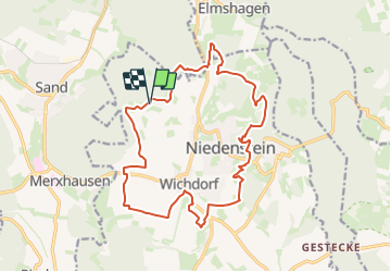
Ruta A pie de 16,4 km a descubrir en Hesse, Schwalm-Eder-Kreis, Niedenstein. Esta ruta ha sido propuesta por SityTrail - itinéraires balisés pédestres.
Descripción
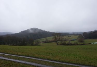
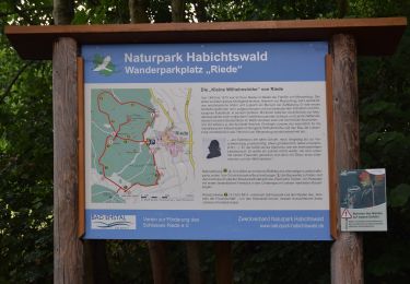
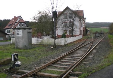
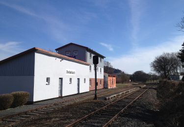
Die Extratour führt Sie am Rande des Habichtswaldes entlang, in die anschließenden Tallandschaft des Chattengaus. Zwischen Wäldern und Wiesen erhalten Sie einen Ausblick auf rund 60 km entfernte Dörfer und Wälder. Frühzeitliche Höhensiedlungen und geschichtsträchtige Böden erzählen von ihrer früheren Bevölkerung. Ein Farbspiel der Natur lässt sich hier zu jeder Jahreszeit bewundern.
Sitio web: https://www.urlaub-habichtswald.de/touren/h5-im-bann-der-chatten
Localización
Comentarios
Excursiones cerca
![Excursión A pie Niedenstein - Niedenstein, N3 - Sengelsberg - Photo](https://media.geolcdn.com/t/375/260/4ed4a3a2-bd5e-4fad-8f78-44d080b6d336.jpeg&format=jpg&maxdim=2)
![A pie A pie](https://static1.geolcdn.com/sitytour/trail-icons/100.png)
A pie
![](/images/other/stat-length.png)
![](https://static1.geolcdn.com/siteimages/upload/files/16400158638029165_repeat_loop_refresh_sync_direction_icon.png)
![Excursión A pie Bad Emstal - Rundwanderweg](https://media.geolcdn.com/t/375/260/6152dd1e-c62a-41d9-ac07-c6e6a253257c.jpeg&format=jpg&maxdim=2)
![A pie A pie](https://static1.geolcdn.com/sitytour/trail-icons/100.png)
A pie
![](/images/other/stat-length.png)
![](https://static1.geolcdn.com/siteimages/upload/files/16400158638029165_repeat_loop_refresh_sync_direction_icon.png)
![Excursión A pie Bad Emstal - Naturparkweg 2 - Photo](https://media.geolcdn.com/t/375/260/56644780-7d07-49f2-8524-c7cbbaefe392.jpeg&format=jpg&maxdim=2)
![A pie A pie](https://static1.geolcdn.com/sitytour/trail-icons/100.png)
A pie
![](/images/other/stat-length.png)
![](https://static1.geolcdn.com/siteimages/upload/files/16400158638029165_repeat_loop_refresh_sync_direction_icon.png)
![Excursión A pie Schauenburg - Schauenburg, S5 - Photo](https://media.geolcdn.com/t/375/260/6a77dc7f-f009-4e54-bde5-58b683fb2794.jpeg&format=jpg&maxdim=2)
![A pie A pie](https://static1.geolcdn.com/sitytour/trail-icons/100.png)
A pie
![](/images/other/stat-length.png)
![](https://static1.geolcdn.com/siteimages/upload/files/16400158638029165_repeat_loop_refresh_sync_direction_icon.png)
![Excursión A pie Gudensberg - Gestecke - Niedenstein - Photo](https://media.geolcdn.com/t/375/260/a26f92b6-32e7-469f-a02f-37ebc420b105.jpeg&format=jpg&maxdim=2)
![A pie A pie](https://static1.geolcdn.com/sitytour/trail-icons/100.png)
A pie
![](/images/other/stat-length.png)
![](https://static1.geolcdn.com/siteimages/upload/files/16400158638029165_repeat_loop_refresh_sync_direction_icon.png)
![Excursión A pie Schauenburg - Schauenburg-Breitenbach, Rundweg 1 - Photo](https://media.geolcdn.com/t/375/260/032608dc-851a-4041-9641-fe96126ffeaa.jpeg&format=jpg&maxdim=2)
![A pie A pie](https://static1.geolcdn.com/sitytour/trail-icons/100.png)
A pie
![](/images/other/stat-length.png)
![](https://static1.geolcdn.com/siteimages/upload/files/16400158638029165_repeat_loop_refresh_sync_direction_icon.png)
![Excursión A pie Bad Emstal - Schauenburg, S1 - Photo](https://media.geolcdn.com/t/375/260/032608dc-851a-4041-9641-fe96126ffeaa.jpeg&format=jpg&maxdim=2)
![A pie A pie](https://static1.geolcdn.com/sitytour/trail-icons/100.png)
A pie
![](/images/other/stat-length.png)
![](https://static1.geolcdn.com/siteimages/upload/files/16400158638029165_repeat_loop_refresh_sync_direction_icon.png)
![Excursión A pie Niedenstein - Niedenstein, N5 - Rundweg zur Ruine Falkenstein - Photo](https://media.geolcdn.com/t/375/260/4ed4a3a2-bd5e-4fad-8f78-44d080b6d336.jpeg&format=jpg&maxdim=2)
![A pie A pie](https://static1.geolcdn.com/sitytour/trail-icons/100.png)
A pie
![](/images/other/stat-length.png)
![](https://static1.geolcdn.com/siteimages/upload/files/16400158638029165_repeat_loop_refresh_sync_direction_icon.png)
![Excursión A pie Bad Emstal - Naturparkweg 1 - Photo](https://media.geolcdn.com/t/375/260/56644780-7d07-49f2-8524-c7cbbaefe392.jpeg&format=jpg&maxdim=2)
![A pie A pie](https://static1.geolcdn.com/sitytour/trail-icons/100.png)
A pie
![](/images/other/stat-length.png)
![](https://static1.geolcdn.com/siteimages/upload/files/16400158638029165_repeat_loop_refresh_sync_direction_icon.png)