![](/images/other/stat-length.png)
![Excursión A pie Ense - Fürstenberg-Rundweg bei Neheim Dreieck - Photo](https://media.geolcdn.com/t/1900/400/ext.pjpeg?maxdim=2&url=https%3A%2F%2Fmedia.geolcdn.com%2Ff%2Fbd944918-932e-4fb7-82e7-beb10887c35d.jpeg)
Fürstenberg-Rundweg bei Neheim Dreieck
SityTrail - itinéraires balisés pédestres
Tous les sentiers balisés d’Europe PRO
![Longitud](/images/other/stat-length.png)
Longitud
4,8 km
![Altitud máxima](https://static1.geolcdn.com/siteimages/upload/files/1508320355ic_sort_altitude_max_24dp.png)
Altitud máxima
288 m
![Desnivel positivo](https://static1.geolcdn.com/siteimages/upload/files/1508320355ic_sort_den_pos_24dp.png)
Desnivel positivo
167 m
![Km-Effort](/images/other/stat-length.png)
Km-Effort
7 km
![Altitud mínima](https://static1.geolcdn.com/siteimages/upload/files/1508320355ic_sort_altitude_min_24dp.png)
Altitud mínima
165 m
![Desnivel negativo](https://static1.geolcdn.com/siteimages/upload/files/1508320355ic_sort_den_neg_24dp.png)
Desnivel negativo
138 m
![Boucle](https://static1.geolcdn.com/siteimages/upload/files/16400158638029165_repeat_loop_refresh_sync_direction_icon.png)
Boucle
No
Baliza
Fecha de creación :
2022-02-11 14:13:27.227
Última modificación :
2022-02-11 14:13:27.227
![A pie](https://static1.geolcdn.com/sitytour/trail-icons/100.png)
1h34
Dificultad : Fácil
![Escanee este código QR para abrir la excursión en la aplicación SityTrail](https://capi.geolives.com/qq0zvz2zws4bq2lad0pu/sitytour/trails/3092235/qr.png?size=200)
Aplicación GPS de excursión GRATIS
A propósito
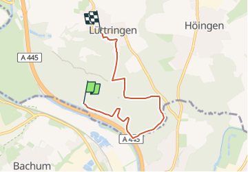
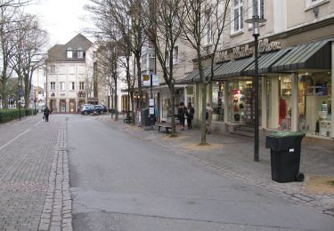
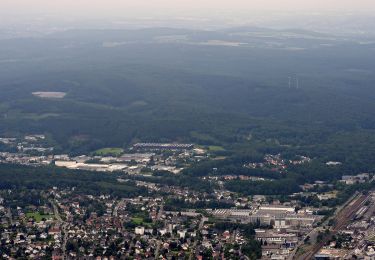
Ruta A pie de 4,8 km a descubrir en Renania del Norte-Westfalia, Kreis Soest, Ense. Esta ruta ha sido propuesta por SityTrail - itinéraires balisés pédestres.
Descripción
Trail created by Sauerländischer Gebirgsverein.
Symbol: Weißes unausgefülltes Dreieck auf schwarzem Grund
Localización
País:
Germany
Región :
Renania del Norte-Westfalia
Departamento/provincia :
Kreis Soest
Municipio :
Ense
Localidad:
Höingen
Salida:(Dec)
Salida:(UTM)
426555 ; 5702864 (32U) N.
Comentarios
Excursiones cerca
![Excursión A pie Arnsberg - [Dreieck] - Photo](https://media.geolcdn.com/t/375/260/ext.jpg?maxdim=2&url=https%3A%2F%2Fmedia.geolcdn.com%2Ff%2Fd81aec76-bcc3-4142-a7ee-5c25b52faed3.jpeg)
![A pie A pie](https://static1.geolcdn.com/sitytour/trail-icons/100.png)
[Dreieck]
A pie
Fácil
Arnsberg,
Renania del Norte-Westfalia,
Hochsauerlandkreis,
Germany
![](/images/other/stat-length.png)
4,3 km | 4,8 km-effort
1h 6min
![](https://static1.geolcdn.com/siteimages/upload/files/16400158638029165_repeat_loop_refresh_sync_direction_icon.png)
No
![Excursión A pie Arnsberg - V-Weg - Rund um Voßwinkel - Photo](https://media.geolcdn.com/t/375/260/ext.jpg?maxdim=2&url=https%3A%2F%2Fmedia.geolcdn.com%2Ff%2F82af1985-47db-46b6-b93f-ea2d12118fe5.jpeg)
![A pie A pie](https://static1.geolcdn.com/sitytour/trail-icons/100.png)
V-Weg - Rund um Voßwinkel
A pie
Fácil
Arnsberg,
Renania del Norte-Westfalia,
Hochsauerlandkreis,
Germany
![](/images/other/stat-length.png)
11,4 km | 14,2 km-effort
3h 13min
![](https://static1.geolcdn.com/siteimages/upload/files/16400158638029165_repeat_loop_refresh_sync_direction_icon.png)
Sí
![Excursión A pie Arnsberg - Hüstener Freiheitsweg - Photo](https://media.geolcdn.com/t/375/260/ext.jpg?maxdim=2&url=https%3A%2F%2Fmedia.geolcdn.com%2Ff%2Faf31ca38-bbae-4784-aa24-a2b97f8cf049.jpeg)
![A pie A pie](https://static1.geolcdn.com/sitytour/trail-icons/100.png)
Hüstener Freiheitsweg
A pie
Medio
Arnsberg,
Renania del Norte-Westfalia,
Hochsauerlandkreis,
Germany
![](/images/other/stat-length.png)
17,1 km | 22 km-effort
4h 55min
![](https://static1.geolcdn.com/siteimages/upload/files/16400158638029165_repeat_loop_refresh_sync_direction_icon.png)
Sí
![Excursión A pie Arnsberg - Balken Talsperrenweg - Photo](https://media.geolcdn.com/t/375/260/ext.jpg?maxdim=2&url=https%3A%2F%2Fmedia.geolcdn.com%2Ff%2Fe08b6576-17ff-42a2-87a0-0e8d5ea814d3.jpeg)
![A pie A pie](https://static1.geolcdn.com/sitytour/trail-icons/100.png)
Balken Talsperrenweg
A pie
Fácil
Arnsberg,
Renania del Norte-Westfalia,
Hochsauerlandkreis,
Germany
![](/images/other/stat-length.png)
5,1 km | 6,9 km-effort
1h 34min
![](https://static1.geolcdn.com/siteimages/upload/files/16400158638029165_repeat_loop_refresh_sync_direction_icon.png)
No
![Excursión A pie Arnsberg - Himmelpforten Rundweg - Photo](https://media.geolcdn.com/t/375/260/ext.jpg?maxdim=2&url=https%3A%2F%2Fmedia.geolcdn.com%2Ff%2F6f2c2bdd-0783-4bee-8c9d-3ec39af7336d.jpeg)
![A pie A pie](https://static1.geolcdn.com/sitytour/trail-icons/100.png)
Himmelpforten Rundweg
A pie
Fácil
Arnsberg,
Renania del Norte-Westfalia,
Hochsauerlandkreis,
Germany
![](/images/other/stat-length.png)
14,3 km | 19 km-effort
4h 19min
![](https://static1.geolcdn.com/siteimages/upload/files/16400158638029165_repeat_loop_refresh_sync_direction_icon.png)
No
![Excursión A pie Arnsberg - Entenpfad nach Bruchhausen hohles Dreieck - Photo](https://media.geolcdn.com/t/375/260/ext.jpg?maxdim=2&url=https%3A%2F%2Fmedia.geolcdn.com%2Ff%2F5ee9f033-025b-4cd5-b5ba-c5a9b1e2f13b.jpeg)
![A pie A pie](https://static1.geolcdn.com/sitytour/trail-icons/100.png)
Entenpfad nach Bruchhausen hohles Dreieck
A pie
Fácil
Arnsberg,
Renania del Norte-Westfalia,
Hochsauerlandkreis,
Germany
![](/images/other/stat-length.png)
5,5 km | 7,3 km-effort
1h 39min
![](https://static1.geolcdn.com/siteimages/upload/files/16400158638029165_repeat_loop_refresh_sync_direction_icon.png)
No
![Excursión A pie Arnsberg - [-] Wanderweg Balken (Arnsberg) - Photo](https://media.geolcdn.com/t/375/260/ext.jpg?maxdim=2&url=https%3A%2F%2Fmedia.geolcdn.com%2Ff%2Faf31ca38-bbae-4784-aa24-a2b97f8cf049.jpeg)
![A pie A pie](https://static1.geolcdn.com/sitytour/trail-icons/100.png)
[-] Wanderweg Balken (Arnsberg)
A pie
Fácil
Arnsberg,
Renania del Norte-Westfalia,
Hochsauerlandkreis,
Germany
![](/images/other/stat-length.png)
8,7 km | 11,2 km-effort
2h 33min
![](https://static1.geolcdn.com/siteimages/upload/files/16400158638029165_repeat_loop_refresh_sync_direction_icon.png)
No
![Excursión A pie Arnsberg - [Quadrat] Luerwald Rundweg - Photo](https://media.geolcdn.com/t/375/260/ext.jpg?maxdim=2&url=https%3A%2F%2Fmedia.geolcdn.com%2Ff%2F956801ea-cad4-4d8d-ac8e-4517bcdfc5db.jpeg)
![A pie A pie](https://static1.geolcdn.com/sitytour/trail-icons/100.png)
[Quadrat] Luerwald Rundweg
A pie
Fácil
Arnsberg,
Renania del Norte-Westfalia,
Hochsauerlandkreis,
Germany
![](/images/other/stat-length.png)
5,5 km | 6,8 km-effort
1h 33min
![](https://static1.geolcdn.com/siteimages/upload/files/16400158638029165_repeat_loop_refresh_sync_direction_icon.png)
No
![Excursión A pie Arnsberg - Im Luerwald bei Neheim A4 - Photo](https://media.geolcdn.com/t/375/260/ext.jpg?maxdim=2&url=https%3A%2F%2Fmedia.geolcdn.com%2Ff%2F956801ea-cad4-4d8d-ac8e-4517bcdfc5db.jpeg)
![A pie A pie](https://static1.geolcdn.com/sitytour/trail-icons/100.png)
Im Luerwald bei Neheim A4
A pie
Fácil
Arnsberg,
Renania del Norte-Westfalia,
Hochsauerlandkreis,
Germany
![](/images/other/stat-length.png)
7,3 km | 9,3 km-effort
2h 7min
![](https://static1.geolcdn.com/siteimages/upload/files/16400158638029165_repeat_loop_refresh_sync_direction_icon.png)
Sí