![](/images/other/stat-length.png)
![Excursión A pie Stolberg - Stolberg Rundweg 1 - Photo](https://media.geolcdn.com/t/1900/400/a577aa09-5d97-44fb-950f-181c01c4b6cd.jpeg&format=pjpeg&maxdim=2)
Stolberg Rundweg 1
SityTrail - itinéraires balisés pédestres
Tous les sentiers balisés d’Europe GUIDE+
![Longitud](/images/other/stat-length.png)
Longitud
9 km
![Altitud máxima](https://static1.geolcdn.com/siteimages/upload/files/1508320355ic_sort_altitude_max_24dp.png)
Altitud máxima
281 m
![Desnivel positivo](https://static1.geolcdn.com/siteimages/upload/files/1508320355ic_sort_den_pos_24dp.png)
Desnivel positivo
189 m
![Km-Effort](/images/other/stat-length.png)
Km-Effort
11,4 km
![Altitud mínima](https://static1.geolcdn.com/siteimages/upload/files/1508320355ic_sort_altitude_min_24dp.png)
Altitud mínima
178 m
![Desnivel negativo](https://static1.geolcdn.com/siteimages/upload/files/1508320355ic_sort_den_neg_24dp.png)
Desnivel negativo
143 m
![Boucle](https://static1.geolcdn.com/siteimages/upload/files/16400158638029165_repeat_loop_refresh_sync_direction_icon.png)
Boucle
No
Baliza
Fecha de creación :
2022-02-11 13:54:11.466
Última modificación :
2022-02-11 13:54:11.466
![A pie](https://static1.geolcdn.com/sitytour/trail-icons/100.png)
2h35
Dificultad : Fácil
![Escanee este código QR para abrir la excursión en la aplicación SityTrail](https://capi.geolives.com/qq0zvz2zws4bq2lad0pu/sitytour/trails/3091463/qr.png?size=200)
Aplicación GPS de excursión GRATIS
A propósito
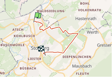
Ruta A pie de 9 km a descubrir en Renania del Norte-Westfalia, Städteregion Aachen, Stolberg. Esta ruta ha sido propuesta por SityTrail - itinéraires balisés pédestres.
Descripción
Trail created by Eifelverein.
Localización
País:
Germany
Región :
Renania del Norte-Westfalia
Departamento/provincia :
Städteregion Aachen
Municipio :
Stolberg
Localidad:
Unknown
Salida:(Dec)
Salida:(UTM)
304247 ; 5629969 (32U) N.
Comentarios
Excursiones cerca
![Excursión A pie Stolberg - Lehmjöres-Weg - Photo](https://media.geolcdn.com/t/375/260/ee8e7fc8-d58f-400a-8ab7-fcb5c3d99b0a.jpeg&format=jpg&maxdim=2)
![A pie A pie](https://static1.geolcdn.com/sitytour/trail-icons/100.png)
Lehmjöres-Weg
A pie
Fácil
Stolberg,
Renania del Norte-Westfalia,
Städteregion Aachen,
Germany
![](/images/other/stat-length.png)
12,7 km | 16,5 km-effort
3h 44min
![](https://static1.geolcdn.com/siteimages/upload/files/16400158638029165_repeat_loop_refresh_sync_direction_icon.png)
Sí
![Excursión A pie Aquisgrán - Forsthausrundweg - Photo](https://media.geolcdn.com/t/375/260/797caef6-ca7a-4981-b4fb-dfb0e5e1c0ab.jpeg&format=jpg&maxdim=2)
![A pie A pie](https://static1.geolcdn.com/sitytour/trail-icons/100.png)
Forsthausrundweg
A pie
Fácil
Aquisgrán,
Renania del Norte-Westfalia,
Städteregion Aachen,
Germany
![](/images/other/stat-length.png)
5,2 km | 5,8 km-effort
1h 19min
![](https://static1.geolcdn.com/siteimages/upload/files/16400158638029165_repeat_loop_refresh_sync_direction_icon.png)
Sí
![Excursión A pie Aquisgrán - IndeRoute - Photo](https://media.geolcdn.com/t/375/260/5b45f3d2-bacb-401d-82e5-6a813ae291fc.jpeg&format=jpg&maxdim=2)
![A pie A pie](https://static1.geolcdn.com/sitytour/trail-icons/100.png)
IndeRoute
A pie
Fácil
Aquisgrán,
Renania del Norte-Westfalia,
Städteregion Aachen,
Germany
![](/images/other/stat-length.png)
6,5 km | 8,2 km-effort
1h 52min
![](https://static1.geolcdn.com/siteimages/upload/files/16400158638029165_repeat_loop_refresh_sync_direction_icon.png)
No
![Excursión A pie Eschweiler - Eschweiler Bachweg - Photo](https://media.geolcdn.com/t/375/260/da331c82-6b93-4335-8a41-9b8a196f8d22.jpeg&format=jpg&maxdim=2)
![A pie A pie](https://static1.geolcdn.com/sitytour/trail-icons/100.png)
Eschweiler Bachweg
A pie
Medio
Eschweiler,
Renania del Norte-Westfalia,
Städteregion Aachen,
Germany
![](/images/other/stat-length.png)
22 km | 26 km-effort
5h 52min
![](https://static1.geolcdn.com/siteimages/upload/files/16400158638029165_repeat_loop_refresh_sync_direction_icon.png)
Sí
![Excursión A pie Eschweiler - Eschweiler Mühlenweg - Photo](https://media.geolcdn.com/t/375/260/794a0236-8c54-488b-a336-5fe19c410c34.jpeg&format=jpg&maxdim=2)
![A pie A pie](https://static1.geolcdn.com/sitytour/trail-icons/100.png)
Eschweiler Mühlenweg
A pie
Fácil
Eschweiler,
Renania del Norte-Westfalia,
Städteregion Aachen,
Germany
![](/images/other/stat-length.png)
14,1 km | 16,2 km-effort
3h 41min
![](https://static1.geolcdn.com/siteimages/upload/files/16400158638029165_repeat_loop_refresh_sync_direction_icon.png)
Sí
![Excursión A pie Aquisgrán - [B3] Rundweg Freund/Vennbahn - Photo](https://media.geolcdn.com/t/375/260/7403d14c-636d-4fe2-9285-9b5d6ebe2687.jpeg&format=jpg&maxdim=2)
![A pie A pie](https://static1.geolcdn.com/sitytour/trail-icons/100.png)
[B3] Rundweg Freund/Vennbahn
A pie
Fácil
Aquisgrán,
Renania del Norte-Westfalia,
Städteregion Aachen,
Germany
![](/images/other/stat-length.png)
8,7 km | 10,5 km-effort
2h 22min
![](https://static1.geolcdn.com/siteimages/upload/files/16400158638029165_repeat_loop_refresh_sync_direction_icon.png)
Sí
![Excursión A pie Aquisgrán - [B2] Rundweg Brander Feld - Photo](https://media.geolcdn.com/t/375/260/e83256ca-dc38-4ff1-a908-0baf40b53d68.jpeg&format=jpg&maxdim=2)
![A pie A pie](https://static1.geolcdn.com/sitytour/trail-icons/100.png)
[B2] Rundweg Brander Feld
A pie
Fácil
Aquisgrán,
Renania del Norte-Westfalia,
Städteregion Aachen,
Germany
![](/images/other/stat-length.png)
7,1 km | 8 km-effort
1h 48min
![](https://static1.geolcdn.com/siteimages/upload/files/16400158638029165_repeat_loop_refresh_sync_direction_icon.png)
No
![Excursión A pie Aquisgrán - [B5] Indetal-Rundweg - Photo](https://media.geolcdn.com/t/375/260/6959ee59-d6d5-4d7a-9031-66fd8a4549f5.jpeg&format=jpg&maxdim=2)
![A pie A pie](https://static1.geolcdn.com/sitytour/trail-icons/100.png)
[B5] Indetal-Rundweg
A pie
Fácil
Aquisgrán,
Renania del Norte-Westfalia,
Städteregion Aachen,
Germany
![](/images/other/stat-length.png)
3,4 km | 4,3 km-effort
58min
![](https://static1.geolcdn.com/siteimages/upload/files/16400158638029165_repeat_loop_refresh_sync_direction_icon.png)
Sí
![Excursión A pie Stolberg - Süssendell Rundweg A2 - Photo](https://media.geolcdn.com/t/375/260/ext.jpg?maxdim=2&url=https%3A%2F%2Fstatic1.geolcdn.com%2Fsiteimages%2Fupload%2Ffiles%2F1545311037marcheuse_200dpi.jpg)
![A pie A pie](https://static1.geolcdn.com/sitytour/trail-icons/100.png)
Süssendell Rundweg A2
A pie
Fácil
Stolberg,
Renania del Norte-Westfalia,
Städteregion Aachen,
Germany
![](/images/other/stat-length.png)
3,1 km | 3,7 km-effort
50min
![](https://static1.geolcdn.com/siteimages/upload/files/16400158638029165_repeat_loop_refresh_sync_direction_icon.png)
No