


3,7 km | 4,4 km-effort
![Excursión A pie Detmold - Rundwanderweg A1 [Grotenburg] - Photo](https://media.geolcdn.com/t/1900/400/4f1234d5-714f-42ad-8f0b-f8de13961882.jpeg&format=pjpeg&maxdim=2)

Tous les sentiers balisés d’Europe GUIDE+


Aplicación GPS de excursión GRATIS
 SityTrail
IGN / Institutos geográficos
SityTrail World
El mundo es suyo
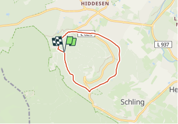
Ruta A pie de 4,6 km a descubrir en Renania del Norte-Westfalia, Kreis Lippe, Detmold. Esta ruta ha sido propuesta por SityTrail - itinéraires balisés pédestres.
Symbol: Weißer Text A1 auf schwarzem Grund
![Excursión A pie Detmold - Rundwanderweg A1 [Grotenburg] - Photo 1](https://media.geolcdn.com/t/2048/auto/ee20b83d-07fb-4787-9a0f-f9869f155adf.jpeg&format=jpg&maxdim=0 "Excursión A pie Detmold - Rundwanderweg A1 [Grotenburg] - Photo 1")
![Excursión A pie Detmold - Rundwanderweg A1 [Grotenburg] - Photo 2](https://media.geolcdn.com/t/2048/auto/1dba94aa-382d-4a12-95d1-c5ca7592ecad.jpeg&format=jpg&maxdim=0 "Excursión A pie Detmold - Rundwanderweg A1 [Grotenburg] - Photo 2")
![Excursión A pie Detmold - Rundwanderweg A1 [Grotenburg] - Photo 3](https://media.geolcdn.com/t/2048/auto/c660fb4b-ac08-4a88-976f-4d40e7009a62.jpeg&format=jpg&maxdim=0 "Excursión A pie Detmold - Rundwanderweg A1 [Grotenburg] - Photo 3")
![Excursión A pie Detmold - Rundwanderweg A1 [Grotenburg] - Photo 4](https://media.geolcdn.com/t/2048/auto/10420e2c-af9b-4796-970c-995734bf5455.jpeg&format=jpg&maxdim=0 "Excursión A pie Detmold - Rundwanderweg A1 [Grotenburg] - Photo 4")
![Excursión A pie Detmold - Rundwanderweg A1 [Grotenburg] - Photo 5](https://media.geolcdn.com/t/2048/auto/a0572264-8bc1-4cc9-9dff-2d5b2dafa089.jpeg&format=jpg&maxdim=0 "Excursión A pie Detmold - Rundwanderweg A1 [Grotenburg] - Photo 5")
![Excursión A pie Detmold - Rundwanderweg A1 [Grotenburg] - Photo 6](https://media.geolcdn.com/t/2048/auto/59dcdba1-22cd-442a-9539-aa8c138e05b7.jpeg&format=jpg&maxdim=0 "Excursión A pie Detmold - Rundwanderweg A1 [Grotenburg] - Photo 6")
![Excursión A pie Detmold - Rundwanderweg A1 [Grotenburg] - Photo 7](https://media.geolcdn.com/t/2048/auto/a17d46eb-d880-4485-92f3-558204e154da.jpeg&format=jpg&maxdim=0 "Excursión A pie Detmold - Rundwanderweg A1 [Grotenburg] - Photo 7")
![Excursión A pie Detmold - Rundwanderweg A1 [Grotenburg] - Photo 8](https://media.geolcdn.com/t/2048/auto/f53cf132-ee90-4491-867d-5f6fea23ec09.jpeg&format=jpg&maxdim=0 "Excursión A pie Detmold - Rundwanderweg A1 [Grotenburg] - Photo 8")
![Excursión A pie Detmold - Rundwanderweg A1 [Grotenburg] - Photo 9](https://media.geolcdn.com/t/2048/auto/e8ce0300-4d3f-4ebf-b30c-b1b46b9455c8.jpeg&format=jpg&maxdim=0 "Excursión A pie Detmold - Rundwanderweg A1 [Grotenburg] - Photo 9")
![Excursión A pie Detmold - Rundwanderweg A1 [Grotenburg] - Photo 10](https://media.geolcdn.com/t/2048/auto/4f1234d5-714f-42ad-8f0b-f8de13961882.jpeg&format=jpg&maxdim=0 "Excursión A pie Detmold - Rundwanderweg A1 [Grotenburg] - Photo 10")
A pie
![Excursión A pie Detmold - Rundwanderweg A5 [Berlebeck] - Photo](https://media.geolcdn.com/t/375/260/09e96dc8-2a72-420e-af43-8a0b6d458613.jpeg&format=jpg&maxdim=2)
A pie
A pie
A pie
A pie
![Excursión A pie Horn-Bad Meinberg - Rundwanderweg A2 [Holzhausen-Externsteine] - Photo](https://media.geolcdn.com/t/375/260/496f2643-585c-4ec3-ad5f-48d37358ba78.jpeg&format=jpg&maxdim=2)
A pie
![Excursión A pie Detmold - Alter Postweg [Schlangen-Kreuzkrug bis Detmold] - Photo](https://media.geolcdn.com/t/375/260/9624b63f-e63d-4566-afac-fe6174b35d1f.jpeg&format=jpg&maxdim=2)
A pie
A pie
A pie