


5,5 km | 6,2 km-effort
![Excursión A pie Detmold - Rundwanderweg A1 [Diestelbruch] - Photo](https://media.geolcdn.com/t/1900/400/aaf5bfea-b5f0-4eb2-baf2-316d21f2e560.jpeg&format=pjpeg&maxdim=2)

Tous les sentiers balisés d’Europe GUIDE+


Aplicación GPS de excursión GRATIS
 SityTrail
IGN / Institutos geográficos
SityTrail World
El mundo es suyo
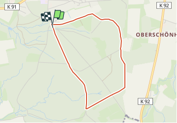
Ruta A pie de 3,3 km a descubrir en Renania del Norte-Westfalia, Kreis Lippe, Detmold. Esta ruta ha sido propuesta por SityTrail - itinéraires balisés pédestres.
Trail created by Teutoburger-Wald-Verein e.V..
![Excursión A pie Detmold - Rundwanderweg A1 [Diestelbruch] - Photo 1](https://media.geolcdn.com/t/2048/auto/a8d43004-9760-48c6-9b9b-197855cbc104.jpeg&format=jpg&maxdim=0 "Excursión A pie Detmold - Rundwanderweg A1 [Diestelbruch] - Photo 1")
![Excursión A pie Detmold - Rundwanderweg A1 [Diestelbruch] - Photo 2](https://media.geolcdn.com/t/2048/auto/2936f066-6837-41f3-a954-042e9a94ee66.jpeg&format=jpg&maxdim=0 "Excursión A pie Detmold - Rundwanderweg A1 [Diestelbruch] - Photo 2")
![Excursión A pie Detmold - Rundwanderweg A1 [Diestelbruch] - Photo 3](https://media.geolcdn.com/t/2048/auto/aaf5bfea-b5f0-4eb2-baf2-316d21f2e560.jpeg&format=jpg&maxdim=0 "Excursión A pie Detmold - Rundwanderweg A1 [Diestelbruch] - Photo 3")
![Excursión A pie Detmold - Rundwanderweg A1 [Diestelbruch] - Photo 4](https://media.geolcdn.com/t/2048/auto/92ca3eb0-e193-4264-b18e-6ef963effd53.jpeg&format=jpg&maxdim=0 "Excursión A pie Detmold - Rundwanderweg A1 [Diestelbruch] - Photo 4")
![Excursión A pie Detmold - Rundwanderweg A1 [Diestelbruch] - Photo 5](https://media.geolcdn.com/t/2048/auto/4c39347b-0b60-48c8-b0ee-c8b6b6801cdb.jpeg&format=jpg&maxdim=0 "Excursión A pie Detmold - Rundwanderweg A1 [Diestelbruch] - Photo 5")
![Excursión A pie Detmold - Rundwanderweg A1 [Diestelbruch] - Photo 6](https://media.geolcdn.com/t/2048/auto/23b30683-2a20-4dd7-b981-32c99de5600f.jpeg&format=jpg&maxdim=0 "Excursión A pie Detmold - Rundwanderweg A1 [Diestelbruch] - Photo 6")
![Excursión A pie Detmold - Rundwanderweg A1 [Diestelbruch] - Photo 7](https://media.geolcdn.com/t/2048/auto/a62e047a-a9e2-40ff-becc-6b3f706839a4.jpeg&format=jpg&maxdim=0 "Excursión A pie Detmold - Rundwanderweg A1 [Diestelbruch] - Photo 7")
![Excursión A pie Detmold - Rundwanderweg A1 [Diestelbruch] - Photo 8](https://media.geolcdn.com/t/2048/auto/91c98508-dec7-470b-a93f-a11541f6de87.jpeg&format=jpg&maxdim=0 "Excursión A pie Detmold - Rundwanderweg A1 [Diestelbruch] - Photo 8")
![Excursión A pie Detmold - Rundwanderweg A1 [Diestelbruch] - Photo 9](https://media.geolcdn.com/t/2048/auto/fc80e557-0acc-45a7-be30-659be9590488.jpeg&format=jpg&maxdim=0 "Excursión A pie Detmold - Rundwanderweg A1 [Diestelbruch] - Photo 9")
![Excursión A pie Detmold - Rundwanderweg A1 [Diestelbruch] - Photo 10](https://media.geolcdn.com/t/2048/auto/ff499da1-e66d-4eb4-a2f1-47cc616b70da.jpeg&format=jpg&maxdim=0 "Excursión A pie Detmold - Rundwanderweg A1 [Diestelbruch] - Photo 10")
A pie
![Excursión A pie Horn-Bad Meinberg - Terrainkurweg 9 [Bad Meinberg] - Photo](https://media.geolcdn.com/t/375/260/415dab2e-d838-41c3-b2c1-c698395be57c.jpeg&format=jpg&maxdim=2)
A pie
![Excursión A pie Horn-Bad Meinberg - Terrainkurweg 5 [Bad Meinberg] - Photo](https://media.geolcdn.com/t/375/260/c6c364b8-a98c-4894-be50-01092c15d2a2.jpeg&format=jpg&maxdim=2)
A pie
![Excursión A pie Horn-Bad Meinberg - Terrainkurweg 4 [Bad Meinberg] - Photo](https://media.geolcdn.com/t/375/260/17855ced-c021-469c-b31b-b1f4ceaf95e0.jpeg&format=jpg&maxdim=2)
A pie
![Excursión A pie Horn-Bad Meinberg - Ruhe - Wanderweg Norderteich [Bad Meinberg] (VitalWanderWelt) - Photo](https://media.geolcdn.com/t/375/260/62948217-785e-4bf8-a3a7-9c99707dba50.jpeg&format=jpg&maxdim=2)
A pie
A pie
![Excursión A pie Detmold - DSV nordic aktiv - schwarze Route [Bad Meinberg] (Nordic Walking) - Photo](https://media.geolcdn.com/t/375/260/aaf5bfea-b5f0-4eb2-baf2-316d21f2e560.jpeg&format=jpg&maxdim=2)
A pie
A pie
A pie