![](/images/other/stat-length.png)
![Excursión A pie Schönwald - Wanderroute Rehau - Schönwald - Photo](https://media.geolcdn.com/t/1900/400/dadb9f78-a2c1-42a0-a020-0335b6593833.jpeg&format=pjpeg&maxdim=2)
Wanderroute Rehau - Schönwald
SityTrail - itinéraires balisés pédestres
Tous les sentiers balisés d’Europe GUIDE+
![Longitud](/images/other/stat-length.png)
Longitud
8 km
![Altitud máxima](https://static1.geolcdn.com/siteimages/upload/files/1508320355ic_sort_altitude_max_24dp.png)
Altitud máxima
689 m
![Desnivel positivo](https://static1.geolcdn.com/siteimages/upload/files/1508320355ic_sort_den_pos_24dp.png)
Desnivel positivo
75 m
![Km-Effort](/images/other/stat-length.png)
Km-Effort
9,4 km
![Altitud mínima](https://static1.geolcdn.com/siteimages/upload/files/1508320355ic_sort_altitude_min_24dp.png)
Altitud mínima
522 m
![Desnivel negativo](https://static1.geolcdn.com/siteimages/upload/files/1508320355ic_sort_den_neg_24dp.png)
Desnivel negativo
205 m
![Boucle](https://static1.geolcdn.com/siteimages/upload/files/16400158638029165_repeat_loop_refresh_sync_direction_icon.png)
Boucle
No
Baliza
Fecha de creación :
2022-02-11 13:11:18.724
Última modificación :
2022-02-11 13:11:18.724
![A pie](https://static1.geolcdn.com/sitytour/trail-icons/100.png)
2h08
Dificultad : Fácil
![Escanee este código QR para abrir la excursión en la aplicación SityTrail](https://capi.geolives.com/qq0zvz2zws4bq2lad0pu/sitytour/trails/3089437/qr.png?size=200)
Aplicación GPS de excursión GRATIS
A propósito
Ruta A pie de 8 km a descubrir en Baviera, Landkreis Wunsiedel im Fichtelgebirge, Schönwald. Esta ruta ha sido propuesta por SityTrail - itinéraires balisés pédestres.
Descripción
Trail created by Fichtelgebirgsverein.
Symbol: blauer Punkt auf weißem Grund
Localización
País:
Germany
Región :
Baviera
Departamento/provincia :
Landkreis Wunsiedel im Fichtelgebirge
Municipio :
Schönwald
Localidad:
Unknown
Salida:(Dec)
Salida:(UTM)
292159 ; 5565360 (33U) N.
Comentarios
Excursiones cerca
![Excursión A pie Martinlamitzer Forst Nord - Oberkotzau-Kornberg - Photo](https://media.geolcdn.com/t/375/260/601fef35-8bd2-4667-b84c-c59b79d455c7.jpeg&format=jpg&maxdim=2)
![A pie A pie](https://static1.geolcdn.com/sitytour/trail-icons/100.png)
Oberkotzau-Kornberg
A pie
Medio
Martinlamitzer Forst Nord,
Baviera,
Landkreis Hof,
Germany
![](/images/other/stat-length.png)
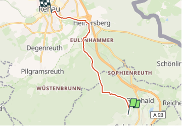
16,4 km | 20 km-effort
4h 33min
![](https://static1.geolcdn.com/siteimages/upload/files/16400158638029165_repeat_loop_refresh_sync_direction_icon.png)
No
![Excursión A pie Rehau - Rundwanderweg 1 Fohrenreuth - Photo](https://media.geolcdn.com/t/375/260/6a952cb8-2f5d-4d42-baff-3936030c0274.jpeg&format=jpg&maxdim=2)
![A pie A pie](https://static1.geolcdn.com/sitytour/trail-icons/100.png)
Rundwanderweg 1 Fohrenreuth
A pie
Fácil
Rehau,
Baviera,
Landkreis Hof,
Germany
![](/images/other/stat-length.png)
7,7 km | 9,6 km-effort
2h 11min
![](https://static1.geolcdn.com/siteimages/upload/files/16400158638029165_repeat_loop_refresh_sync_direction_icon.png)
Sí
![Excursión A pie Rehau - Rundwanderweg 3 Fohrenreuth - Photo](https://media.geolcdn.com/t/375/260/ff87cd7e-0ce7-49c9-a223-bd18eebec758.jpeg&format=jpg&maxdim=2)
![A pie A pie](https://static1.geolcdn.com/sitytour/trail-icons/100.png)
Rundwanderweg 3 Fohrenreuth
A pie
Fácil
Rehau,
Baviera,
Landkreis Hof,
Germany
![](/images/other/stat-length.png)
10,6 km | 13,6 km-effort
3h 6min
![](https://static1.geolcdn.com/siteimages/upload/files/16400158638029165_repeat_loop_refresh_sync_direction_icon.png)
Sí
![Excursión A pie Martinlamitzer Forst Nord - Zubringer Fränkischer Gebirgweg (Schwarzenb./S.) - Photo](https://media.geolcdn.com/t/375/260/5f4c0deb-0530-4ce1-bd74-b7b74cba2131.jpeg&format=jpg&maxdim=2)
![A pie A pie](https://static1.geolcdn.com/sitytour/trail-icons/100.png)
Zubringer Fränkischer Gebirgweg (Schwarzenb./S.)
A pie
Fácil
Martinlamitzer Forst Nord,
Baviera,
Landkreis Hof,
Germany
![](/images/other/stat-length.png)
10,7 km | 12,6 km-effort
2h 51min
![](https://static1.geolcdn.com/siteimages/upload/files/16400158638029165_repeat_loop_refresh_sync_direction_icon.png)
No
![Excursión A pie Schönwald - Rundwanderweg 4 Fohrenreuth - Photo](https://media.geolcdn.com/t/375/260/b1312acc-3fa7-42bc-aece-16fc1fc656e4.jpeg&format=jpg&maxdim=2)
![A pie A pie](https://static1.geolcdn.com/sitytour/trail-icons/100.png)
Rundwanderweg 4 Fohrenreuth
A pie
Fácil
Schönwald,
Baviera,
Landkreis Wunsiedel im Fichtelgebirge,
Germany
![](/images/other/stat-length.png)
9,5 km | 12 km-effort
2h 43min
![](https://static1.geolcdn.com/siteimages/upload/files/16400158638029165_repeat_loop_refresh_sync_direction_icon.png)
Sí
![Excursión A pie Martinlamitzer Forst-Süd - Kornberg - Photo](https://media.geolcdn.com/t/375/260/31f91d47-a828-45c4-b3b1-68f99935677a.jpeg&format=jpg&maxdim=2)
![A pie A pie](https://static1.geolcdn.com/sitytour/trail-icons/100.png)
Kornberg
A pie
Fácil
Martinlamitzer Forst-Süd,
Baviera,
Landkreis Wunsiedel im Fichtelgebirge,
Germany
![](/images/other/stat-length.png)
8,6 km | 10 km-effort
2h 16min
![](https://static1.geolcdn.com/siteimages/upload/files/16400158638029165_repeat_loop_refresh_sync_direction_icon.png)
No
![Excursión A pie Martinlamitzer Forst Nord - Wanderroute Marktleuthen - Kornberg - Photo](https://media.geolcdn.com/t/375/260/601fef35-8bd2-4667-b84c-c59b79d455c7.jpeg&format=jpg&maxdim=2)
![A pie A pie](https://static1.geolcdn.com/sitytour/trail-icons/100.png)
Wanderroute Marktleuthen - Kornberg
A pie
Fácil
Martinlamitzer Forst Nord,
Baviera,
Landkreis Hof,
Germany
![](/images/other/stat-length.png)
7,3 km | 8,6 km-effort
1h 57min
![](https://static1.geolcdn.com/siteimages/upload/files/16400158638029165_repeat_loop_refresh_sync_direction_icon.png)
No
![Excursión A pie Selb - 5 [Selb] - Photo](https://media.geolcdn.com/t/375/260/954419d6-ee41-41a2-8ef2-664e05903a4f.jpeg&format=jpg&maxdim=2)
![A pie A pie](https://static1.geolcdn.com/sitytour/trail-icons/100.png)
5 [Selb]
A pie
Fácil
Selb,
Baviera,
Landkreis Wunsiedel im Fichtelgebirge,
Germany
![](/images/other/stat-length.png)
10,1 km | 12,6 km-effort
2h 52min
![](https://static1.geolcdn.com/siteimages/upload/files/16400158638029165_repeat_loop_refresh_sync_direction_icon.png)
Sí
![Excursión A pie Martinlamitzer Forst-Süd - Schönwald - Vorsuchhütte - Photo](https://media.geolcdn.com/t/375/260/ext.jpg?maxdim=2&url=https%3A%2F%2Fstatic1.geolcdn.com%2Fsiteimages%2Fupload%2Ffiles%2F1545311037marcheuse_200dpi.jpg)
![A pie A pie](https://static1.geolcdn.com/sitytour/trail-icons/100.png)
Schönwald - Vorsuchhütte
A pie
Fácil
Martinlamitzer Forst-Süd,
Baviera,
Landkreis Wunsiedel im Fichtelgebirge,
Germany
![](/images/other/stat-length.png)
4 km | 4,7 km-effort
1h 4min
![](https://static1.geolcdn.com/siteimages/upload/files/16400158638029165_repeat_loop_refresh_sync_direction_icon.png)
No