![](/images/other/stat-length.png)
![Excursión A pie Ennepetal - [Quadrat] Schwelm - Beyenburg - Photo](https://media.geolcdn.com/t/1900/400/ext.pjpeg?maxdim=2&url=https%3A%2F%2Fstatic1.geolcdn.com%2Fsiteimages%2Fupload%2Ffiles%2F1545311037marcheuse_200dpi.jpg)
[Quadrat] Schwelm - Beyenburg
SityTrail - itinéraires balisés pédestres
Tous les sentiers balisés d’Europe GUIDE+
![Longitud](/images/other/stat-length.png)
Longitud
3,6 km
![Altitud máxima](https://static1.geolcdn.com/siteimages/upload/files/1508320355ic_sort_altitude_max_24dp.png)
Altitud máxima
338 m
![Desnivel positivo](https://static1.geolcdn.com/siteimages/upload/files/1508320355ic_sort_den_pos_24dp.png)
Desnivel positivo
31 m
![Km-Effort](/images/other/stat-length.png)
Km-Effort
4,5 km
![Altitud mínima](https://static1.geolcdn.com/siteimages/upload/files/1508320355ic_sort_altitude_min_24dp.png)
Altitud mínima
191 m
![Desnivel negativo](https://static1.geolcdn.com/siteimages/upload/files/1508320355ic_sort_den_neg_24dp.png)
Desnivel negativo
155 m
![Boucle](https://static1.geolcdn.com/siteimages/upload/files/16400158638029165_repeat_loop_refresh_sync_direction_icon.png)
Boucle
No
Baliza
Fecha de creación :
2022-02-11 12:59:29.272
Última modificación :
2022-02-11 12:59:29.272
![A pie](https://static1.geolcdn.com/sitytour/trail-icons/100.png)
1h00
Dificultad : Fácil
![Escanee este código QR para abrir la excursión en la aplicación SityTrail](https://capi.geolives.com/qq0zvz2zws4bq2lad0pu/sitytour/trails/3088813/qr.png?size=200)
Aplicación GPS de excursión GRATIS
A propósito
Ruta A pie de 3,6 km a descubrir en Renania del Norte-Westfalia, Ennepe-Ruhr-Kreis, Ennepetal. Esta ruta ha sido propuesta por SityTrail - itinéraires balisés pédestres.
Descripción
Trail created by Sauerländischer Gebirgsverein.
Localización
País:
Germany
Región :
Renania del Norte-Westfalia
Departamento/provincia :
Ennepe-Ruhr-Kreis
Municipio :
Ennepetal
Localidad:
Unknown
Salida:(Dec)
Salida:(UTM)
382441 ; 5680875 (32U) N.
Comentarios
Excursiones cerca
![Excursión A pie Ennepetal - GEV-Nirgena - EN-Voerde - EN-Ahlhausen - Photo](https://media.geolcdn.com/t/375/260/da141f89-6e3f-4d71-b3a3-70cff173877e.jpeg&format=jpg&maxdim=2)
![A pie A pie](https://static1.geolcdn.com/sitytour/trail-icons/100.png)
GEV-Nirgena - EN-Voerde - EN-Ahlhausen
A pie
Fácil
Ennepetal,
Renania del Norte-Westfalia,
Ennepe-Ruhr-Kreis,
Germany
![](/images/other/stat-length.png)
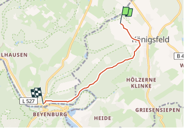
10,4 km | 14,3 km-effort
3h 15min
![](https://static1.geolcdn.com/siteimages/upload/files/16400158638029165_repeat_loop_refresh_sync_direction_icon.png)
No
![Excursión A pie Ennepetal - Stucken Rundweg A2 - Photo](https://media.geolcdn.com/t/375/260/fead74cd-a6fa-47c4-a015-3bab1e51071a.jpeg&format=jpg&maxdim=2)
![A pie A pie](https://static1.geolcdn.com/sitytour/trail-icons/100.png)
Stucken Rundweg A2
A pie
Fácil
Ennepetal,
Renania del Norte-Westfalia,
Ennepe-Ruhr-Kreis,
Germany
![](/images/other/stat-length.png)
4,1 km | 6 km-effort
1h 21min
![](https://static1.geolcdn.com/siteimages/upload/files/16400158638029165_repeat_loop_refresh_sync_direction_icon.png)
Sí
![Excursión A pie Schwelm - Rüggeberg-Beyenburg - Photo](https://media.geolcdn.com/t/375/260/02b123f2-cce4-4e86-b142-598c3c9f678e.jpeg&format=jpg&maxdim=2)
![A pie A pie](https://static1.geolcdn.com/sitytour/trail-icons/100.png)
Rüggeberg-Beyenburg
A pie
Fácil
Schwelm,
Renania del Norte-Westfalia,
Ennepe-Ruhr-Kreis,
Germany
![](/images/other/stat-length.png)
4,8 km | 6,6 km-effort
1h 29min
![](https://static1.geolcdn.com/siteimages/upload/files/16400158638029165_repeat_loop_refresh_sync_direction_icon.png)
No
![Excursión A pie Schwelm - (S) Schwelmer Rundweg - Photo](https://media.geolcdn.com/t/375/260/a0c52fd2-dba0-467a-8fe3-93e4017dae9b.jpeg&format=jpg&maxdim=2)
![A pie A pie](https://static1.geolcdn.com/sitytour/trail-icons/100.png)
(S) Schwelmer Rundweg
A pie
Medio
Schwelm,
Renania del Norte-Westfalia,
Ennepe-Ruhr-Kreis,
Germany
![](/images/other/stat-length.png)
22 km | 28 km-effort
6h 27min
![](https://static1.geolcdn.com/siteimages/upload/files/16400158638029165_repeat_loop_refresh_sync_direction_icon.png)
Sí
![Excursión A pie Ennepetal - Ennepetaler Rundweg - Photo](https://media.geolcdn.com/t/375/260/21da2367-fb27-4e94-9be3-4f8ac0f58149.jpeg&format=jpg&maxdim=2)
![A pie A pie](https://static1.geolcdn.com/sitytour/trail-icons/100.png)
Ennepetaler Rundweg
A pie
Medio
Ennepetal,
Renania del Norte-Westfalia,
Ennepe-Ruhr-Kreis,
Germany
![](/images/other/stat-length.png)
15,7 km | 21 km-effort
4h 50min
![](https://static1.geolcdn.com/siteimages/upload/files/16400158638029165_repeat_loop_refresh_sync_direction_icon.png)
No
![Excursión A pie - Walbrecken Rundweg A4 - Photo](https://media.geolcdn.com/t/375/260/b74ca738-04ca-46d6-88cd-6e49fb11f97f.jpeg&format=jpg&maxdim=2)
![A pie A pie](https://static1.geolcdn.com/sitytour/trail-icons/100.png)
Walbrecken Rundweg A4
A pie
Fácil
,
Renania del Norte-Westfalia,
Wuppertal,
Germany
![](/images/other/stat-length.png)
7,5 km | 9,4 km-effort
2h 7min
![](https://static1.geolcdn.com/siteimages/upload/files/16400158638029165_repeat_loop_refresh_sync_direction_icon.png)
No
![Excursión A pie Gevelsberg - Rund um Gevelsberg G - Photo](https://media.geolcdn.com/t/375/260/21da2367-fb27-4e94-9be3-4f8ac0f58149.jpeg&format=jpg&maxdim=2)
![A pie A pie](https://static1.geolcdn.com/sitytour/trail-icons/100.png)
Rund um Gevelsberg G
A pie
Fácil
Gevelsberg,
Renania del Norte-Westfalia,
Ennepe-Ruhr-Kreis,
Germany
![](/images/other/stat-length.png)
14,2 km | 18,6 km-effort
4h 13min
![](https://static1.geolcdn.com/siteimages/upload/files/16400158638029165_repeat_loop_refresh_sync_direction_icon.png)
Sí
![Excursión A pie Ennepetal - Ortswanderweg A3 - Photo](https://media.geolcdn.com/t/375/260/ext.jpg?maxdim=2&url=https%3A%2F%2Fstatic1.geolcdn.com%2Fsiteimages%2Fupload%2Ffiles%2F1545311037marcheuse_200dpi.jpg)
![A pie A pie](https://static1.geolcdn.com/sitytour/trail-icons/100.png)
Ortswanderweg A3
A pie
Fácil
Ennepetal,
Renania del Norte-Westfalia,
Ennepe-Ruhr-Kreis,
Germany
![](/images/other/stat-length.png)
4,8 km | 6,7 km-effort
1h 31min
![](https://static1.geolcdn.com/siteimages/upload/files/16400158638029165_repeat_loop_refresh_sync_direction_icon.png)
Sí
![Excursión A pie Ennepetal - Rundweg A2 Heilenbecke - Photo](https://media.geolcdn.com/t/375/260/ext.jpg?maxdim=2&url=https%3A%2F%2Fstatic1.geolcdn.com%2Fsiteimages%2Fupload%2Ffiles%2F1545311037marcheuse_200dpi.jpg)
![A pie A pie](https://static1.geolcdn.com/sitytour/trail-icons/100.png)
Rundweg A2 Heilenbecke
A pie
Fácil
Ennepetal,
Renania del Norte-Westfalia,
Ennepe-Ruhr-Kreis,
Germany
![](/images/other/stat-length.png)
3,2 km | 4,6 km-effort
1h 2min
![](https://static1.geolcdn.com/siteimages/upload/files/16400158638029165_repeat_loop_refresh_sync_direction_icon.png)
No