![](/images/other/stat-length.png)
![Excursión A pie Unknown - Wildnispfad - Photo](https://media.geolcdn.com/t/1900/400/dbc018e5-eb33-434b-a2da-0acf93c98ce3.jpeg&format=pjpeg&maxdim=2)
Wildnispfad
SityTrail - itinéraires balisés pédestres
Tous les sentiers balisés d’Europe GUIDE+
![Longitud](/images/other/stat-length.png)
Longitud
3,4 km
![Altitud máxima](https://static1.geolcdn.com/siteimages/upload/files/1508320355ic_sort_altitude_max_24dp.png)
Altitud máxima
825 m
![Desnivel positivo](https://static1.geolcdn.com/siteimages/upload/files/1508320355ic_sort_den_pos_24dp.png)
Desnivel positivo
77 m
![Km-Effort](/images/other/stat-length.png)
Km-Effort
4,4 km
![Altitud mínima](https://static1.geolcdn.com/siteimages/upload/files/1508320355ic_sort_altitude_min_24dp.png)
Altitud mínima
764 m
![Desnivel negativo](https://static1.geolcdn.com/siteimages/upload/files/1508320355ic_sort_den_neg_24dp.png)
Desnivel negativo
81 m
![Boucle](https://static1.geolcdn.com/siteimages/upload/files/16400158638029165_repeat_loop_refresh_sync_direction_icon.png)
Boucle
Sí
Baliza
Fecha de creación :
2022-02-11 12:56:09.18
Última modificación :
2022-02-11 12:56:09.18
![A pie](https://static1.geolcdn.com/sitytour/trail-icons/100.png)
1h00
Dificultad : Fácil
![Escanee este código QR para abrir la excursión en la aplicación SityTrail](https://capi.geolives.com/qq0zvz2zws4bq2lad0pu/sitytour/trails/3088615/qr.png?size=200)
Aplicación GPS de excursión GRATIS
A propósito
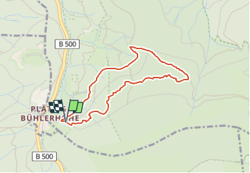
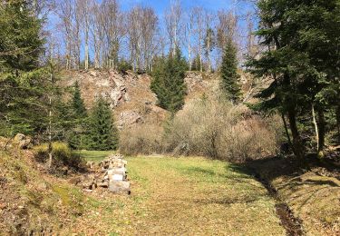
Ruta A pie de 3,4 km a descubrir en Baden-Wurtemberg, Baden-Baden. Esta ruta ha sido propuesta por SityTrail - itinéraires balisés pédestres.
Descripción
approaches symbol as much as possible
Symbol: Black woodpecker siluhette on a white background in a green circle
Localización
País:
Germany
Región :
Baden-Wurtemberg
Departamento/provincia :
Baden-Baden
Municipio :
Unknown
Localidad:
Unknown
Salida:(Dec)
Salida:(UTM)
443679 ; 5391001 (32U) N.
Comentarios
Excursiones cerca
![Excursión A pie - Am Froschbach - Am Urbach - Photo](https://media.geolcdn.com/t/375/260/822c358c-9ebc-4500-af5c-9a6c2c3c1dad.jpeg&format=jpg&maxdim=2)
![A pie A pie](https://static1.geolcdn.com/sitytour/trail-icons/100.png)
Am Froschbach - Am Urbach
A pie
Fácil
,
Baden-Wurtemberg,
Baden-Baden,
Germany
![](/images/other/stat-length.png)
3,9 km | 4,5 km-effort
1h 1min
![](https://static1.geolcdn.com/siteimages/upload/files/16400158638029165_repeat_loop_refresh_sync_direction_icon.png)
No
![Excursión A pie Bühl - Gertelbach-Rundweg - Photo](https://media.geolcdn.com/t/375/260/c8c7aa2c-3bb8-46e9-839f-aeb198fa7bb5.jpeg&format=jpg&maxdim=2)
![A pie A pie](https://static1.geolcdn.com/sitytour/trail-icons/100.png)
Gertelbach-Rundweg
A pie
Fácil
Bühl,
Baden-Wurtemberg,
Landkreis Rastatt,
Germany
![](/images/other/stat-length.png)
8,9 km | 14,6 km-effort
3h 19min
![](https://static1.geolcdn.com/siteimages/upload/files/16400158638029165_repeat_loop_refresh_sync_direction_icon.png)
Sí
![Excursión A pie Forbach - Winterwanderweg rote Lache 1 - Photo](https://media.geolcdn.com/t/375/260/a590b01a-ee10-4d9f-beb6-8980dc73ca0d.jpeg&format=jpg&maxdim=2)
![A pie A pie](https://static1.geolcdn.com/sitytour/trail-icons/100.png)
Winterwanderweg rote Lache 1
A pie
Fácil
Forbach,
Baden-Wurtemberg,
Landkreis Rastatt,
Germany
![](/images/other/stat-length.png)
4,9 km | 7,3 km-effort
1h 39min
![](https://static1.geolcdn.com/siteimages/upload/files/16400158638029165_repeat_loop_refresh_sync_direction_icon.png)
Sí
![Excursión A pie - Luchspfad - Photo](https://media.geolcdn.com/t/375/260/dbc018e5-eb33-434b-a2da-0acf93c98ce3.jpeg&format=jpg&maxdim=2)
![A pie A pie](https://static1.geolcdn.com/sitytour/trail-icons/100.png)
![Excursión A pie - Steinberg Rundweg - Photo](https://media.geolcdn.com/t/375/260/d9e7f2f7-def4-4d76-af12-cb6ab513d113.jpeg&format=jpg&maxdim=2)
![A pie A pie](https://static1.geolcdn.com/sitytour/trail-icons/100.png)
Steinberg Rundweg
A pie
Fácil
,
Baden-Wurtemberg,
Baden-Baden,
Germany
![](/images/other/stat-length.png)
3,8 km | 4,6 km-effort
1h 3min
![](https://static1.geolcdn.com/siteimages/upload/files/16400158638029165_repeat_loop_refresh_sync_direction_icon.png)
Sí
![Excursión A pie - Scherrhof - Am Ruberg - Photo](https://media.geolcdn.com/t/375/260/d9e7f2f7-def4-4d76-af12-cb6ab513d113.jpeg&format=jpg&maxdim=2)
![A pie A pie](https://static1.geolcdn.com/sitytour/trail-icons/100.png)
Scherrhof - Am Ruberg
A pie
Fácil
,
Baden-Wurtemberg,
Baden-Baden,
Germany
![](/images/other/stat-length.png)
3,2 km | 4,1 km-effort
55min
![](https://static1.geolcdn.com/siteimages/upload/files/16400158638029165_repeat_loop_refresh_sync_direction_icon.png)
No
![Excursión Senderismo Bühlertal - Gertelbach-Rundweg - Photo](https://media.geolcdn.com/t/375/260/ext.jpg?maxdim=2&url=https%3A%2F%2Fstatic1.geolcdn.com%2Fsiteimages%2Fupload%2Ffiles%2F1553511878bg_sport_marche.png)
![Senderismo Senderismo](https://static1.geolcdn.com/sitytour/trail-icons/101.png)
Gertelbach-Rundweg
Senderismo
Medio
Bühlertal,
Baden-Wurtemberg,
Landkreis Rastatt,
Germany
![](/images/other/stat-length.png)
9,5 km | 15,4 km-effort
3h 30min
![](https://static1.geolcdn.com/siteimages/upload/files/16400158638029165_repeat_loop_refresh_sync_direction_icon.png)
Sí
![Excursión Otra actividad Bühlertal - Gertelbach Wasserfälle Rundweg - Photo](https://media.geolcdn.com/t/375/260/ext.jpg?maxdim=2&url=https%3A%2F%2Fstatic1.geolcdn.com%2Fsiteimages%2Fupload%2Ffiles%2F1545311037marcheuse_200dpi.jpg)
![Otra actividad Otra actividad](https://static1.geolcdn.com/sitytour/trail-icons/900.png)
Gertelbach Wasserfälle Rundweg
Otra actividad
Muy fácil
Bühlertal,
Baden-Wurtemberg,
Landkreis Rastatt,
Germany
![](/images/other/stat-length.png)
9,5 km | 15,5 km-effort
Desconocido
![](https://static1.geolcdn.com/siteimages/upload/files/16400158638029165_repeat_loop_refresh_sync_direction_icon.png)
Sí
![Excursión Otra actividad Bühlertal - Drei Gipfeltour - Photo](https://media.geolcdn.com/t/375/260/ext.jpg?maxdim=2&url=https%3A%2F%2Fstatic1.geolcdn.com%2Fsiteimages%2Fupload%2Ffiles%2F1545311037marcheuse_200dpi.jpg)
![Otra actividad Otra actividad](https://static1.geolcdn.com/sitytour/trail-icons/900.png)
Drei Gipfeltour
Otra actividad
Muy fácil
Bühlertal,
Baden-Wurtemberg,
Landkreis Rastatt,
Germany
![](/images/other/stat-length.png)
64 km | 88 km-effort
Desconocido
![](https://static1.geolcdn.com/siteimages/upload/files/16400158638029165_repeat_loop_refresh_sync_direction_icon.png)
Sí