


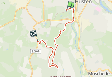

17,1 km | 22 km-effort
![Excursión A pie Arnsberg - [h] Panoramaweg Herdringen - Photo](https://media.geolcdn.com/t/1900/400/7f2d3098-ee3f-438d-932e-0e492dfc4c63.jpeg&format=pjpeg&maxdim=2)

Tous les sentiers balisés d’Europe GUIDE+


Aplicación GPS de excursión GRATIS
 SityTrail
IGN / Institutos geográficos
SityTrail World
El mundo es suyo
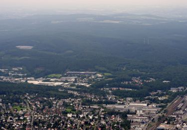
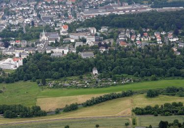
Ruta A pie de 5,5 km a descubrir en Renania del Norte-Westfalia, Hochsauerlandkreis, Arnsberg. Esta ruta ha sido propuesta por SityTrail - itinéraires balisés pédestres.
Trail created by Sauerländischer Gebirgsverein.
Symbol: Kleines weißes h in weißem Kreis auf schwaarzem Grund
![Excursión A pie Arnsberg - [h] Panoramaweg Herdringen - Photo 1](https://media.geolcdn.com/t/2048/auto/e2b47295-f344-4296-970f-ce57795f390e.jpeg&format=jpg&maxdim=0 "Excursión A pie Arnsberg - [h] Panoramaweg Herdringen - Photo 1")
![Excursión A pie Arnsberg - [h] Panoramaweg Herdringen - Photo 2](https://media.geolcdn.com/t/2048/auto/1d23f410-8c35-4b14-83e2-2cba866686a8.jpeg&format=jpg&maxdim=0 "Excursión A pie Arnsberg - [h] Panoramaweg Herdringen - Photo 2")
![Excursión A pie Arnsberg - [h] Panoramaweg Herdringen - Photo 3](https://media.geolcdn.com/t/2048/auto/8bfabf92-9176-41bc-8b90-8be71b02d73a.jpeg&format=jpg&maxdim=0 "Excursión A pie Arnsberg - [h] Panoramaweg Herdringen - Photo 3")
![Excursión A pie Arnsberg - [h] Panoramaweg Herdringen - Photo 4](https://media.geolcdn.com/t/2048/auto/ac4107d8-f7c8-4d79-9606-abdded1fc113.jpeg&format=jpg&maxdim=0 "Excursión A pie Arnsberg - [h] Panoramaweg Herdringen - Photo 4")
![Excursión A pie Arnsberg - [h] Panoramaweg Herdringen - Photo 5](https://media.geolcdn.com/t/2048/auto/7da6815f-0f74-4ba6-8d32-bf256cca501c.jpeg&format=jpg&maxdim=0 "Excursión A pie Arnsberg - [h] Panoramaweg Herdringen - Photo 5")
![Excursión A pie Arnsberg - [h] Panoramaweg Herdringen - Photo 6](https://media.geolcdn.com/t/2048/auto/0a492446-eb60-40bf-a317-09ad9aeadd26.jpeg&format=jpg&maxdim=0 "Excursión A pie Arnsberg - [h] Panoramaweg Herdringen - Photo 6")
![Excursión A pie Arnsberg - [h] Panoramaweg Herdringen - Photo 7](https://media.geolcdn.com/t/2048/auto/0810414c-191a-40b5-b3dd-a2dcbcbeca3b.jpeg&format=jpg&maxdim=0 "Excursión A pie Arnsberg - [h] Panoramaweg Herdringen - Photo 7")
![Excursión A pie Arnsberg - [h] Panoramaweg Herdringen - Photo 8](https://media.geolcdn.com/t/2048/auto/4e803c34-7c95-406a-9a1d-449567ab72e4.jpeg&format=jpg&maxdim=0 "Excursión A pie Arnsberg - [h] Panoramaweg Herdringen - Photo 8")
![Excursión A pie Arnsberg - [h] Panoramaweg Herdringen - Photo 9](https://media.geolcdn.com/t/2048/auto/4af4e8bf-1fc0-45fd-a8f8-af6f9889b9f7.jpeg&format=jpg&maxdim=0 "Excursión A pie Arnsberg - [h] Panoramaweg Herdringen - Photo 9")
![Excursión A pie Arnsberg - [h] Panoramaweg Herdringen - Photo 10](https://media.geolcdn.com/t/2048/auto/7f2d3098-ee3f-438d-932e-0e492dfc4c63.jpeg&format=jpg&maxdim=0 "Excursión A pie Arnsberg - [h] Panoramaweg Herdringen - Photo 10")
A pie
A pie
A pie
A pie
A pie
A pie
![Excursión A pie Arnsberg - [Quadrat] Luerwald Rundweg - Photo](https://media.geolcdn.com/t/375/260/956801ea-cad4-4d8d-ac8e-4517bcdfc5db.jpeg&format=jpg&maxdim=2)
A pie
A pie
A pie