![](/images/other/stat-length.png)
![Excursión A pie Lonnerstadt - Rundweg Lonnerstadt L4 - Photo](https://media.geolcdn.com/t/1900/400/ext.pjpeg?maxdim=2&url=https%3A%2F%2Fstatic1.geolcdn.com%2Fsiteimages%2Fupload%2Ffiles%2F1545311037marcheuse_200dpi.jpg)
Rundweg Lonnerstadt L4
SityTrail - itinéraires balisés pédestres
Tous les sentiers balisés d’Europe GUIDE+
![Longitud](/images/other/stat-length.png)
Longitud
6,2 km
![Altitud máxima](https://static1.geolcdn.com/siteimages/upload/files/1508320355ic_sort_altitude_max_24dp.png)
Altitud máxima
365 m
![Desnivel positivo](https://static1.geolcdn.com/siteimages/upload/files/1508320355ic_sort_den_pos_24dp.png)
Desnivel positivo
107 m
![Km-Effort](/images/other/stat-length.png)
Km-Effort
7,6 km
![Altitud mínima](https://static1.geolcdn.com/siteimages/upload/files/1508320355ic_sort_altitude_min_24dp.png)
Altitud mínima
286 m
![Desnivel negativo](https://static1.geolcdn.com/siteimages/upload/files/1508320355ic_sort_den_neg_24dp.png)
Desnivel negativo
102 m
![Boucle](https://static1.geolcdn.com/siteimages/upload/files/16400158638029165_repeat_loop_refresh_sync_direction_icon.png)
Boucle
Sí
Baliza
Fecha de creación :
2022-02-11 12:54:22.978
Última modificación :
2022-02-11 12:54:22.978
![A pie](https://static1.geolcdn.com/sitytour/trail-icons/100.png)
1h43
Dificultad : Fácil
![Escanee este código QR para abrir la excursión en la aplicación SityTrail](https://capi.geolives.com/qq0zvz2zws4bq2lad0pu/sitytour/trails/3088464/qr.png?size=200)
Aplicación GPS de excursión GRATIS
A propósito
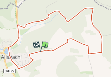
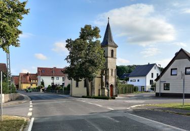
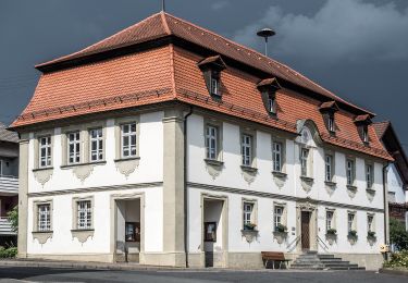
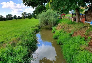
Ruta A pie de 6,2 km a descubrir en Baviera, Landkreis Erlangen-Höchstadt, Lonnerstadt. Esta ruta ha sido propuesta por SityTrail - itinéraires balisés pédestres.
Descripción
Trail created by Naturfreunde Lonnerstadt und Obst- und Gartenbauverein Fetzelhofen/Ailsbach.
Symbol: Schwarzes L4 auf gelbem Hintergrundrund
Localización
País:
Germany
Región :
Baviera
Departamento/provincia :
Landkreis Erlangen-Höchstadt
Municipio :
Lonnerstadt
Localidad:
Unknown
Salida:(Dec)
Salida:(UTM)
625130 ; 5508609 (32U) N.
Comentarios
Excursiones cerca
![Excursión A pie Uehlfeld - Kräuter-Rundweg Uehlfeld - Photo](https://media.geolcdn.com/t/375/260/48250117-8b40-484c-8b89-1f6ec968c33d.jpeg&format=jpg&maxdim=2)
![A pie A pie](https://static1.geolcdn.com/sitytour/trail-icons/100.png)
Kräuter-Rundweg Uehlfeld
A pie
Medio
Uehlfeld,
Baviera,
Landkreis Neustadt an der Aisch-Bad Windsheim,
Germany
![](/images/other/stat-length.png)
23 km | 27 km-effort
6h 5min
![](https://static1.geolcdn.com/siteimages/upload/files/16400158638029165_repeat_loop_refresh_sync_direction_icon.png)
Sí
![Excursión A pie Uehlfeld - Karpfen-Rundweg Uehlfeld - Photo](https://media.geolcdn.com/t/375/260/6e73a48e-e790-4f50-8c65-571f1003efc9.jpeg&format=jpg&maxdim=2)
![A pie A pie](https://static1.geolcdn.com/sitytour/trail-icons/100.png)
Karpfen-Rundweg Uehlfeld
A pie
Difícil
Uehlfeld,
Baviera,
Landkreis Neustadt an der Aisch-Bad Windsheim,
Germany
![](/images/other/stat-length.png)
27 km | 31 km-effort
7h 4min
![](https://static1.geolcdn.com/siteimages/upload/files/16400158638029165_repeat_loop_refresh_sync_direction_icon.png)
Sí
![Excursión A pie Wachenroth - Weingartsgreuth W7 - Photo](https://media.geolcdn.com/t/375/260/2f696976-22ab-43fb-920d-5bced5d6d33d.jpeg&format=jpg&maxdim=2)
![A pie A pie](https://static1.geolcdn.com/sitytour/trail-icons/100.png)
Weingartsgreuth W7
A pie
Medio
Wachenroth,
Baviera,
Landkreis Erlangen-Höchstadt,
Germany
![](/images/other/stat-length.png)
17,6 km | 20 km-effort
4h 35min
![](https://static1.geolcdn.com/siteimages/upload/files/16400158638029165_repeat_loop_refresh_sync_direction_icon.png)
Sí
![Excursión A pie Wachenroth - Weingartsgreuth W5 - Photo](https://media.geolcdn.com/t/375/260/b5f1b179-fe3e-4485-b875-c0acf4854dd8.jpeg&format=jpg&maxdim=2)
![A pie A pie](https://static1.geolcdn.com/sitytour/trail-icons/100.png)
Weingartsgreuth W5
A pie
Fácil
Wachenroth,
Baviera,
Landkreis Erlangen-Höchstadt,
Germany
![](/images/other/stat-length.png)
12,8 km | 15,6 km-effort
3h 32min
![](https://static1.geolcdn.com/siteimages/upload/files/16400158638029165_repeat_loop_refresh_sync_direction_icon.png)
Sí
![Excursión A pie Wachenroth - Weingartsgreuth W8 - Photo](https://media.geolcdn.com/t/375/260/fb61f25e-7b12-4a24-9e0f-311d4287a9b4.jpeg&format=jpg&maxdim=2)
![A pie A pie](https://static1.geolcdn.com/sitytour/trail-icons/100.png)
Weingartsgreuth W8
A pie
Fácil
Wachenroth,
Baviera,
Landkreis Erlangen-Höchstadt,
Germany
![](/images/other/stat-length.png)
9,6 km | 11,6 km-effort
2h 38min
![](https://static1.geolcdn.com/siteimages/upload/files/16400158638029165_repeat_loop_refresh_sync_direction_icon.png)
Sí
![Excursión A pie Mühlhausen - Ökumenischer Bibelweg - Photo](https://media.geolcdn.com/t/375/260/fb61f25e-7b12-4a24-9e0f-311d4287a9b4.jpeg&format=jpg&maxdim=2)
![A pie A pie](https://static1.geolcdn.com/sitytour/trail-icons/100.png)
Ökumenischer Bibelweg
A pie
Fácil
Mühlhausen,
Baviera,
Landkreis Erlangen-Höchstadt,
Germany
![](/images/other/stat-length.png)
10,7 km | 13,1 km-effort
2h 58min
![](https://static1.geolcdn.com/siteimages/upload/files/16400158638029165_repeat_loop_refresh_sync_direction_icon.png)
No
![Excursión A pie Lonnerstadt - Rundweg Lonnerstadt L2 - Photo](https://media.geolcdn.com/t/375/260/5c3855bf-7492-440d-be0b-e3fd9b6ee6ba.jpeg&format=jpg&maxdim=2)
![A pie A pie](https://static1.geolcdn.com/sitytour/trail-icons/100.png)
Rundweg Lonnerstadt L2
A pie
Fácil
Lonnerstadt,
Baviera,
Landkreis Erlangen-Höchstadt,
Germany
![](/images/other/stat-length.png)
8,7 km | 11 km-effort
2h 30min
![](https://static1.geolcdn.com/siteimages/upload/files/16400158638029165_repeat_loop_refresh_sync_direction_icon.png)
Sí
![Excursión A pie Lonnerstadt - Rundweg Lonnerstadt L1 - Photo](https://media.geolcdn.com/t/375/260/5c3855bf-7492-440d-be0b-e3fd9b6ee6ba.jpeg&format=jpg&maxdim=2)
![A pie A pie](https://static1.geolcdn.com/sitytour/trail-icons/100.png)
Rundweg Lonnerstadt L1
A pie
Fácil
Lonnerstadt,
Baviera,
Landkreis Erlangen-Höchstadt,
Germany
![](/images/other/stat-length.png)
6,8 km | 8,1 km-effort
1h 50min
![](https://static1.geolcdn.com/siteimages/upload/files/16400158638029165_repeat_loop_refresh_sync_direction_icon.png)
Sí
![Excursión A pie Wachenroth - Rundweg Wachenroth W 1 - Photo](https://media.geolcdn.com/t/375/260/ext.jpg?maxdim=2&url=https%3A%2F%2Fstatic1.geolcdn.com%2Fsiteimages%2Fupload%2Ffiles%2F1545311037marcheuse_200dpi.jpg)
![A pie A pie](https://static1.geolcdn.com/sitytour/trail-icons/100.png)
Rundweg Wachenroth W 1
A pie
Fácil
Wachenroth,
Baviera,
Landkreis Erlangen-Höchstadt,
Germany
![](/images/other/stat-length.png)
3,2 km | 4,4 km-effort
1h 0min
![](https://static1.geolcdn.com/siteimages/upload/files/16400158638029165_repeat_loop_refresh_sync_direction_icon.png)
No