![](/images/other/stat-length.png)
![Excursión A pie Nohfelden - Offizierspfad Imsbach - Photo](https://media.geolcdn.com/t/1900/400/620bd641-6a47-46da-925f-976a5ac5e67c.jpeg&format=pjpeg&maxdim=2)
Offizierspfad Imsbach
SityTrail - itinéraires balisés pédestres
Tous les sentiers balisés d’Europe GUIDE+
![Longitud](/images/other/stat-length.png)
Longitud
11,4 km
![Altitud máxima](https://static1.geolcdn.com/siteimages/upload/files/1508320355ic_sort_altitude_max_24dp.png)
Altitud máxima
477 m
![Desnivel positivo](https://static1.geolcdn.com/siteimages/upload/files/1508320355ic_sort_den_pos_24dp.png)
Desnivel positivo
278 m
![Km-Effort](/images/other/stat-length.png)
Km-Effort
15 km
![Altitud mínima](https://static1.geolcdn.com/siteimages/upload/files/1508320355ic_sort_altitude_min_24dp.png)
Altitud mínima
345 m
![Desnivel negativo](https://static1.geolcdn.com/siteimages/upload/files/1508320355ic_sort_den_neg_24dp.png)
Desnivel negativo
270 m
![Boucle](https://static1.geolcdn.com/siteimages/upload/files/16400158638029165_repeat_loop_refresh_sync_direction_icon.png)
Boucle
Sí
Baliza
Fecha de creación :
2022-02-11 12:52:36.127
Última modificación :
2022-02-11 12:52:36.127
![A pie](https://static1.geolcdn.com/sitytour/trail-icons/100.png)
3h25
Dificultad : Fácil
![Escanee este código QR para abrir la excursión en la aplicación SityTrail](https://capi.geolives.com/qq0zvz2zws4bq2lad0pu/sitytour/trails/3088293/qr.png?size=200)
Aplicación GPS de excursión GRATIS
A propósito
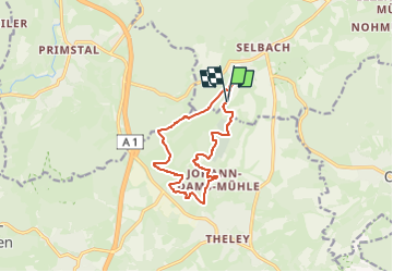
Ruta A pie de 11,4 km a descubrir en Sarre, Landkreis St. Wendel, Nohfelden. Esta ruta ha sido propuesta por SityTrail - itinéraires balisés pédestres.
Descripción
Symbol: Offiziersmütze, 2 Berge mit Baum und 1 Fluss mit blauem Schriftzug "Offizierspfad Imsbach" auf weißem Grund
Localización
País:
Germany
Región :
Sarre
Departamento/provincia :
Landkreis St. Wendel
Municipio :
Nohfelden
Localidad:
Selbach
Salida:(Dec)
Salida:(UTM)
357183 ; 5487877 (32U) N.
Comentarios
Excursiones cerca
![Excursión A pie Tholey - Schaumberg-Tafeltour - Photo](https://media.geolcdn.com/t/375/260/0131e4e2-adf0-4659-a8b6-d74265dd8779.jpeg&format=jpg&maxdim=2)
![A pie A pie](https://static1.geolcdn.com/sitytour/trail-icons/100.png)
Schaumberg-Tafeltour
A pie
Fácil
Tholey,
Sarre,
Landkreis St. Wendel,
Germany
![](/images/other/stat-length.png)
10,8 km | 16,2 km-effort
3h 41min
![](https://static1.geolcdn.com/siteimages/upload/files/16400158638029165_repeat_loop_refresh_sync_direction_icon.png)
Sí
![Excursión A pie Sankt Wendel - 5-Weiher-Tour - Photo](https://media.geolcdn.com/t/375/260/da4badfa-248f-4c25-87b7-655e26c3ac4d.jpeg&format=jpg&maxdim=2)
![A pie A pie](https://static1.geolcdn.com/sitytour/trail-icons/100.png)
5-Weiher-Tour
A pie
Fácil
Sankt Wendel,
Sarre,
Landkreis St. Wendel,
Germany
![](/images/other/stat-length.png)
11,7 km | 15,2 km-effort
3h 26min
![](https://static1.geolcdn.com/siteimages/upload/files/16400158638029165_repeat_loop_refresh_sync_direction_icon.png)
Sí
![Excursión A pie Oberthal - Obertaler Grenzweg - Photo](https://media.geolcdn.com/t/375/260/ext.jpg?maxdim=2&url=https%3A%2F%2Fstatic1.geolcdn.com%2Fsiteimages%2Fupload%2Ffiles%2F1545311037marcheuse_200dpi.jpg)
![A pie A pie](https://static1.geolcdn.com/sitytour/trail-icons/100.png)
Obertaler Grenzweg
A pie
Fácil
Oberthal,
Sarre,
Landkreis St. Wendel,
Germany
![](/images/other/stat-length.png)
8,5 km | 11,8 km-effort
2h 41min
![](https://static1.geolcdn.com/siteimages/upload/files/16400158638029165_repeat_loop_refresh_sync_direction_icon.png)
Sí
![Excursión Senderismo Nohfelden - bostalsee - Photo](https://media.geolcdn.com/t/375/260/fa441e02-f40a-4416-8a2e-474197cb2d5a.jpg&format=jpg&maxdim=2)
![Senderismo Senderismo](https://static1.geolcdn.com/sitytour/trail-icons/101.png)
bostalsee
Senderismo
Medio
Nohfelden,
Sarre,
Landkreis St. Wendel,
Germany
![](/images/other/stat-length.png)
7,8 km | 9,2 km-effort
2h 4min
![](https://static1.geolcdn.com/siteimages/upload/files/16400158638029165_repeat_loop_refresh_sync_direction_icon.png)
No
![Excursión A pie Tholey - Johannes-Kühn-Weg - Photo](https://media.geolcdn.com/t/375/260/ext.jpg?maxdim=2&url=https%3A%2F%2Fstatic1.geolcdn.com%2Fsiteimages%2Fupload%2Ffiles%2F1545311037marcheuse_200dpi.jpg)
![A pie A pie](https://static1.geolcdn.com/sitytour/trail-icons/100.png)
Johannes-Kühn-Weg
A pie
Fácil
Tholey,
Sarre,
Landkreis St. Wendel,
Germany
![](/images/other/stat-length.png)
4 km | 5,7 km-effort
1h 18min
![](https://static1.geolcdn.com/siteimages/upload/files/16400158638029165_repeat_loop_refresh_sync_direction_icon.png)
No
![Excursión Bici de carretera Nohfelden - Bostalsee Loop - Photo](https://media.geolcdn.com/t/375/260/ext.jpg?maxdim=2&url=https%3A%2F%2Fstatic1.geolcdn.com%2Fsiteimages%2Fupload%2Ffiles%2F1524743154velo.jpg)
![Bici de carretera Bici de carretera](https://static1.geolcdn.com/sitytour/trail-icons/201.png)
Bostalsee Loop
Bici de carretera
Difícil
Nohfelden,
Sarre,
Landkreis St. Wendel,
Germany
![](/images/other/stat-length.png)
31 km | 39 km-effort
2h 21min
![](https://static1.geolcdn.com/siteimages/upload/files/16400158638029165_repeat_loop_refresh_sync_direction_icon.png)
No