![](/images/other/stat-length.png)
![Excursión A pie Selb - 5 [Selb] - Photo](https://media.geolcdn.com/t/1900/400/954419d6-ee41-41a2-8ef2-664e05903a4f.jpeg&format=pjpeg&maxdim=2)
5 [Selb]
SityTrail - itinéraires balisés pédestres
Tous les sentiers balisés d’Europe GUIDE+
![Longitud](/images/other/stat-length.png)
Longitud
10,1 km
![Altitud máxima](https://static1.geolcdn.com/siteimages/upload/files/1508320355ic_sort_altitude_max_24dp.png)
Altitud máxima
637 m
![Desnivel positivo](https://static1.geolcdn.com/siteimages/upload/files/1508320355ic_sort_den_pos_24dp.png)
Desnivel positivo
187 m
![Km-Effort](/images/other/stat-length.png)
Km-Effort
12,6 km
![Altitud mínima](https://static1.geolcdn.com/siteimages/upload/files/1508320355ic_sort_altitude_min_24dp.png)
Altitud mínima
563 m
![Desnivel negativo](https://static1.geolcdn.com/siteimages/upload/files/1508320355ic_sort_den_neg_24dp.png)
Desnivel negativo
187 m
![Boucle](https://static1.geolcdn.com/siteimages/upload/files/16400158638029165_repeat_loop_refresh_sync_direction_icon.png)
Boucle
Sí
Baliza
Fecha de creación :
2022-02-11 12:47:12.425
Última modificación :
2022-02-11 12:47:12.425
![A pie](https://static1.geolcdn.com/sitytour/trail-icons/100.png)
2h52
Dificultad : Fácil
![Escanee este código QR para abrir la excursión en la aplicación SityTrail](https://capi.geolives.com/qq0zvz2zws4bq2lad0pu/sitytour/trails/3087879/qr.png?size=200)
Aplicación GPS de excursión GRATIS
A propósito
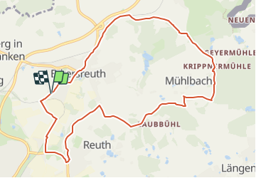
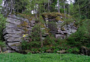
Ruta A pie de 10,1 km a descubrir en Baviera, Landkreis Wunsiedel im Fichtelgebirge, Selb. Esta ruta ha sido propuesta por SityTrail - itinéraires balisés pédestres.
Descripción
Symbol: Schwarze 5 auf gelbem Grund
Localización
País:
Germany
Región :
Baviera
Departamento/provincia :
Landkreis Wunsiedel im Fichtelgebirge
Municipio :
Selb
Localidad:
Unknown
Salida:(Dec)
Salida:(UTM)
295739 ; 5563511 (33U) N.
Comentarios
Excursiones cerca
![Excursión A pie Schönwald - Wanderroute Rehau - Schönwald - Photo](https://media.geolcdn.com/t/375/260/dadb9f78-a2c1-42a0-a020-0335b6593833.jpeg&format=jpg&maxdim=2)
![A pie A pie](https://static1.geolcdn.com/sitytour/trail-icons/100.png)
Wanderroute Rehau - Schönwald
A pie
Fácil
Schönwald,
Baviera,
Landkreis Wunsiedel im Fichtelgebirge,
Germany
![](/images/other/stat-length.png)
8 km | 9,4 km-effort
2h 8min
![](https://static1.geolcdn.com/siteimages/upload/files/16400158638029165_repeat_loop_refresh_sync_direction_icon.png)
No
![Excursión A pie Selb - 7 [Selb] - Photo](https://media.geolcdn.com/t/375/260/2659c846-1fe5-48d7-9ce0-16d70c315673.jpeg&format=jpg&maxdim=2)
![A pie A pie](https://static1.geolcdn.com/sitytour/trail-icons/100.png)
7 [Selb]
A pie
Fácil
Selb,
Baviera,
Landkreis Wunsiedel im Fichtelgebirge,
Germany
![](/images/other/stat-length.png)
6 km | 7,7 km-effort
1h 44min
![](https://static1.geolcdn.com/siteimages/upload/files/16400158638029165_repeat_loop_refresh_sync_direction_icon.png)
Sí
![Excursión A pie Selb - Naturfreundeweg Selb - Photo](https://media.geolcdn.com/t/375/260/c5d6252f-2f09-4d16-a844-dc70b0215c3b.jpeg&format=jpg&maxdim=2)
![A pie A pie](https://static1.geolcdn.com/sitytour/trail-icons/100.png)
Naturfreundeweg Selb
A pie
Fácil
Selb,
Baviera,
Landkreis Wunsiedel im Fichtelgebirge,
Germany
![](/images/other/stat-length.png)
6 km | 7 km-effort
1h 35min
![](https://static1.geolcdn.com/siteimages/upload/files/16400158638029165_repeat_loop_refresh_sync_direction_icon.png)
No
![Excursión A pie Schönwald - Rundwanderweg 7 Schönwald - Photo](https://media.geolcdn.com/t/375/260/5f2c4ffe-5bed-447d-8579-8c5d4248dcd1.jpeg&format=jpg&maxdim=2)
![A pie A pie](https://static1.geolcdn.com/sitytour/trail-icons/100.png)
Rundwanderweg 7 Schönwald
A pie
Fácil
Schönwald,
Baviera,
Landkreis Wunsiedel im Fichtelgebirge,
Germany
![](/images/other/stat-length.png)
3,4 km | 4,3 km-effort
58min
![](https://static1.geolcdn.com/siteimages/upload/files/16400158638029165_repeat_loop_refresh_sync_direction_icon.png)
No
![Excursión A pie Schönwald - Rundwanderweg 8 Schönwald - Photo](https://media.geolcdn.com/t/375/260/5f2c4ffe-5bed-447d-8579-8c5d4248dcd1.jpeg&format=jpg&maxdim=2)
![A pie A pie](https://static1.geolcdn.com/sitytour/trail-icons/100.png)
Rundwanderweg 8 Schönwald
A pie
Fácil
Schönwald,
Baviera,
Landkreis Wunsiedel im Fichtelgebirge,
Germany
![](/images/other/stat-length.png)
4 km | 4,5 km-effort
1h 0min
![](https://static1.geolcdn.com/siteimages/upload/files/16400158638029165_repeat_loop_refresh_sync_direction_icon.png)
No
![Excursión A pie Schönwald - Rundwanderweg 9 Schönwald - Photo](https://media.geolcdn.com/t/375/260/5f2c4ffe-5bed-447d-8579-8c5d4248dcd1.jpeg&format=jpg&maxdim=2)
![A pie A pie](https://static1.geolcdn.com/sitytour/trail-icons/100.png)
Rundwanderweg 9 Schönwald
A pie
Fácil
Schönwald,
Baviera,
Landkreis Wunsiedel im Fichtelgebirge,
Germany
![](/images/other/stat-length.png)
5,5 km | 6,9 km-effort
1h 34min
![](https://static1.geolcdn.com/siteimages/upload/files/16400158638029165_repeat_loop_refresh_sync_direction_icon.png)
No
![Excursión A pie Selb - Hengstberg - Photo](https://media.geolcdn.com/t/375/260/a65d9baa-5712-430b-ad9a-ce39442ae678.jpeg&format=jpg&maxdim=2)
![A pie A pie](https://static1.geolcdn.com/sitytour/trail-icons/100.png)
Hengstberg
A pie
Fácil
Selb,
Baviera,
Landkreis Wunsiedel im Fichtelgebirge,
Germany
![](/images/other/stat-length.png)
7,6 km | 9,1 km-effort
2h 4min
![](https://static1.geolcdn.com/siteimages/upload/files/16400158638029165_repeat_loop_refresh_sync_direction_icon.png)
No
![Excursión A pie Selb - 9 [Selb] - Photo](https://media.geolcdn.com/t/375/260/ext.jpg?maxdim=2&url=https%3A%2F%2Fstatic1.geolcdn.com%2Fsiteimages%2Fupload%2Ffiles%2F1545311037marcheuse_200dpi.jpg)
![A pie A pie](https://static1.geolcdn.com/sitytour/trail-icons/100.png)
9 [Selb]
A pie
Fácil
Selb,
Baviera,
Landkreis Wunsiedel im Fichtelgebirge,
Germany
![](/images/other/stat-length.png)
6,5 km | 8,1 km-effort
1h 50min
![](https://static1.geolcdn.com/siteimages/upload/files/16400158638029165_repeat_loop_refresh_sync_direction_icon.png)
Sí
![Excursión A pie Selb - 4 [Selb] - Photo](https://media.geolcdn.com/t/375/260/ext.jpg?maxdim=2&url=https%3A%2F%2Fstatic1.geolcdn.com%2Fsiteimages%2Fupload%2Ffiles%2F1545311037marcheuse_200dpi.jpg)
![A pie A pie](https://static1.geolcdn.com/sitytour/trail-icons/100.png)
4 [Selb]
A pie
Fácil
Selb,
Baviera,
Landkreis Wunsiedel im Fichtelgebirge,
Germany
![](/images/other/stat-length.png)
6,5 km | 8,5 km-effort
1h 55min
![](https://static1.geolcdn.com/siteimages/upload/files/16400158638029165_repeat_loop_refresh_sync_direction_icon.png)
Sí