![](/images/other/stat-length.png)
![Excursión A pie Osburg - Saar-Hunsrück Steig Zuwegung - Photo](https://media.geolcdn.com/t/1900/400/c1a0ecd1-1843-4921-8968-407ef63da67f.jpeg&format=pjpeg&maxdim=2)
Saar-Hunsrück Steig Zuwegung
SityTrail - itinéraires balisés pédestres
Tous les sentiers balisés d’Europe GUIDE+
![Longitud](/images/other/stat-length.png)
![Altitud máxima](https://static1.geolcdn.com/siteimages/upload/files/1508320355ic_sort_altitude_max_24dp.png)
![Desnivel positivo](https://static1.geolcdn.com/siteimages/upload/files/1508320355ic_sort_den_pos_24dp.png)
![Km-Effort](/images/other/stat-length.png)
![Altitud mínima](https://static1.geolcdn.com/siteimages/upload/files/1508320355ic_sort_altitude_min_24dp.png)
![Desnivel negativo](https://static1.geolcdn.com/siteimages/upload/files/1508320355ic_sort_den_neg_24dp.png)
![Boucle](https://static1.geolcdn.com/siteimages/upload/files/16400158638029165_repeat_loop_refresh_sync_direction_icon.png)
![A pie](https://static1.geolcdn.com/sitytour/trail-icons/100.png)
1h34
Dificultad : Fácil
![Escanee este código QR para abrir la excursión en la aplicación SityTrail](https://capi.geolives.com/qq0zvz2zws4bq2lad0pu/sitytour/trails/3087793/qr.png?size=200)
Aplicación GPS de excursión GRATIS
A propósito
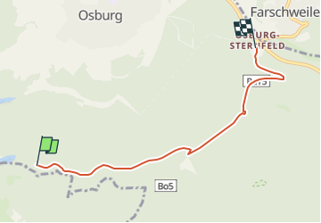
Ruta A pie de 5 km a descubrir en Renania-Palatinado, Landkreis Trier-Saarburg, Osburg. Esta ruta ha sido propuesta por SityTrail - itinéraires balisés pédestres.
Descripción
Trail created by Projektbüro Saar-Hunsrück-Steig.
Diese Relation sollte für alle Zuwegungen des Saar-Hunsrück-Steiges verwendet werden, die durch eine orangefarbene Markierung gekennzeichnet sind
Symbol: Stilisiertes S und H auf orangefarbenem Hintergrund
Localización
Comentarios
Excursiones cerca
![Excursión A pie Gutweiler - Romika-Weg - Photo](https://media.geolcdn.com/t/375/260/644cbb1c-05bc-4e7a-906a-f58ae57c3aa1.jpeg&format=jpg&maxdim=2)
![A pie A pie](https://static1.geolcdn.com/sitytour/trail-icons/100.png)
A pie
![](/images/other/stat-length.png)
![](https://static1.geolcdn.com/siteimages/upload/files/16400158638029165_repeat_loop_refresh_sync_direction_icon.png)
![Excursión A pie Pluwig - Walburga-Wanderweg - Photo](https://media.geolcdn.com/t/375/260/b952f0ab-8e1d-4f5d-a025-5f45e0b4aedb.jpeg&format=jpg&maxdim=2)
![A pie A pie](https://static1.geolcdn.com/sitytour/trail-icons/100.png)
A pie
![](/images/other/stat-length.png)
![](https://static1.geolcdn.com/siteimages/upload/files/16400158638029165_repeat_loop_refresh_sync_direction_icon.png)
![Excursión A pie Morscheid - DE-R - Photo](https://media.geolcdn.com/t/375/260/0b0cdefd-fbad-4d79-acef-5a137d3e9a95.jpeg&format=jpg&maxdim=2)
![A pie A pie](https://static1.geolcdn.com/sitytour/trail-icons/100.png)
A pie
![](/images/other/stat-length.png)
![](https://static1.geolcdn.com/siteimages/upload/files/16400158638029165_repeat_loop_refresh_sync_direction_icon.png)
![Excursión A pie Sommerau - Morscheider Grenzpfad - Photo](https://media.geolcdn.com/t/375/260/9327d8cb-60ee-4a45-a57a-e57e842f85f1.jpeg&format=jpg&maxdim=2)
![A pie A pie](https://static1.geolcdn.com/sitytour/trail-icons/100.png)
A pie
![](/images/other/stat-length.png)
![](https://static1.geolcdn.com/siteimages/upload/files/16400158638029165_repeat_loop_refresh_sync_direction_icon.png)
![Excursión A pie Pluwig - Pluwig 1 - Photo](https://media.geolcdn.com/t/375/260/b952f0ab-8e1d-4f5d-a025-5f45e0b4aedb.jpeg&format=jpg&maxdim=2)
![A pie A pie](https://static1.geolcdn.com/sitytour/trail-icons/100.png)
A pie
![](/images/other/stat-length.png)
![](https://static1.geolcdn.com/siteimages/upload/files/16400158638029165_repeat_loop_refresh_sync_direction_icon.png)
![Excursión A pie Desconocido - Korlingen 1 - Photo](https://media.geolcdn.com/t/375/260/8f5b3fc9-ca42-431f-babc-0124f8354220.jpeg&format=jpg&maxdim=2)
![A pie A pie](https://static1.geolcdn.com/sitytour/trail-icons/100.png)
A pie
![](/images/other/stat-length.png)
![](https://static1.geolcdn.com/siteimages/upload/files/16400158638029165_repeat_loop_refresh_sync_direction_icon.png)
![Excursión A pie Holzerath - Holzerath 1 - Photo](https://media.geolcdn.com/t/375/260/f77a5b65-bf59-41f5-85cb-65ddad0fef57.jpeg&format=jpg&maxdim=2)
![A pie A pie](https://static1.geolcdn.com/sitytour/trail-icons/100.png)
A pie
![](/images/other/stat-length.png)
![](https://static1.geolcdn.com/siteimages/upload/files/16400158638029165_repeat_loop_refresh_sync_direction_icon.png)
![Excursión A pie Schöndorf - Schöndorf 1 - Photo](https://media.geolcdn.com/t/375/260/0b0cdefd-fbad-4d79-acef-5a137d3e9a95.jpeg&format=jpg&maxdim=2)
![A pie A pie](https://static1.geolcdn.com/sitytour/trail-icons/100.png)
A pie
![](/images/other/stat-length.png)
![](https://static1.geolcdn.com/siteimages/upload/files/16400158638029165_repeat_loop_refresh_sync_direction_icon.png)
![Excursión A pie Riveris - Riveristalsperre - Photo](https://media.geolcdn.com/t/375/260/9327d8cb-60ee-4a45-a57a-e57e842f85f1.jpeg&format=jpg&maxdim=2)
![A pie A pie](https://static1.geolcdn.com/sitytour/trail-icons/100.png)
A pie
![](/images/other/stat-length.png)
![](https://static1.geolcdn.com/siteimages/upload/files/16400158638029165_repeat_loop_refresh_sync_direction_icon.png)