![](/images/other/stat-length.png)
![Excursión A pie Desconocido - Gipfelwanderweg Suhl (Thüringer Wald) - Photo](https://media.geolcdn.com/t/1900/400/6bb7536f-38cf-4075-ab68-998255e07ff8.jpeg&format=pjpeg&maxdim=2)
Gipfelwanderweg Suhl (Thüringer Wald)
SityTrail - itinéraires balisés pédestres
Tous les sentiers balisés d’Europe GUIDE+
![Longitud](/images/other/stat-length.png)
Longitud
18 km
![Altitud máxima](https://static1.geolcdn.com/siteimages/upload/files/1508320355ic_sort_altitude_max_24dp.png)
Altitud máxima
945 m
![Desnivel positivo](https://static1.geolcdn.com/siteimages/upload/files/1508320355ic_sort_den_pos_24dp.png)
Desnivel positivo
392 m
![Km-Effort](/images/other/stat-length.png)
Km-Effort
24 km
![Altitud mínima](https://static1.geolcdn.com/siteimages/upload/files/1508320355ic_sort_altitude_min_24dp.png)
Altitud mínima
540 m
![Desnivel negativo](https://static1.geolcdn.com/siteimages/upload/files/1508320355ic_sort_den_neg_24dp.png)
Desnivel negativo
713 m
![Boucle](https://static1.geolcdn.com/siteimages/upload/files/16400158638029165_repeat_loop_refresh_sync_direction_icon.png)
Boucle
No
Baliza
Fecha de creación :
2022-02-11 12:40:10.006
Última modificación :
2022-02-11 12:40:10.006
![A pie](https://static1.geolcdn.com/sitytour/trail-icons/100.png)
5h31
Dificultad : Medio
![Escanee este código QR para abrir la excursión en la aplicación SityTrail](https://capi.geolives.com/qq0zvz2zws4bq2lad0pu/sitytour/trails/3087509/qr.png?size=200)
Aplicación GPS de excursión GRATIS
A propósito
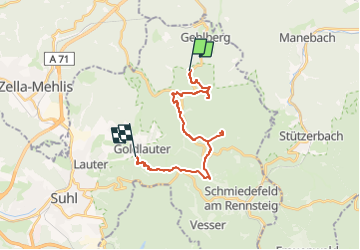
Ruta A pie de 18 km a descubrir en Turingia, Suhl, Desconocido. Esta ruta ha sido propuesta por SityTrail - itinéraires balisés pédestres.
Descripción
Trail created by Kulturamt Stadt Suhl.
Beginn Skistadtion Heidersbach bzw. Pfannrain Goldlauter
Symbol: Rotes Dreieck auf weißem Grund, Spitze nach oben (red-triangle)
Localización
País:
Germany
Región :
Turingia
Departamento/provincia :
Suhl
Municipio :
Desconocido
Localidad:
Gehlberg
Salida:(Dec)
Salida:(UTM)
625704 ; 5614025 (32U) N.
Comentarios
Excursiones cerca
![Excursión A pie Oberhof - Rundweg Oberhof - Photo](https://media.geolcdn.com/t/375/260/0897e82c-e273-46ab-8b48-9a1ec9d46659.jpeg&format=jpg&maxdim=2)
![A pie A pie](https://static1.geolcdn.com/sitytour/trail-icons/100.png)
Rundweg Oberhof
A pie
Fácil
Oberhof,
Turingia,
Landkreis Schmalkalden-Meiningen,
Germany
![](/images/other/stat-length.png)
6 km | 8,1 km-effort
1h 49min
![](https://static1.geolcdn.com/siteimages/upload/files/16400158638029165_repeat_loop_refresh_sync_direction_icon.png)
No
![Excursión A pie Geratal - Rundwanderweg Lütsche-Flößgraben - Photo](https://media.geolcdn.com/t/375/260/8a9b2621-9b90-4120-a048-e59a838772b6.jpeg&format=jpg&maxdim=2)
![A pie A pie](https://static1.geolcdn.com/sitytour/trail-icons/100.png)
Rundwanderweg Lütsche-Flößgraben
A pie
Fácil
Geratal,
Turingia,
Ilm-Kreis,
Germany
![](/images/other/stat-length.png)
11,3 km | 14 km-effort
3h 10min
![](https://static1.geolcdn.com/siteimages/upload/files/16400158638029165_repeat_loop_refresh_sync_direction_icon.png)
No
![Excursión A pie Desconocido - Rennsteigleiter Gehlberg - Photo](https://media.geolcdn.com/t/375/260/bc48c4bd-89db-491c-8e32-3a2849d2c331.jpeg&format=jpg&maxdim=2)
![A pie A pie](https://static1.geolcdn.com/sitytour/trail-icons/100.png)
Rennsteigleiter Gehlberg
A pie
Fácil
Desconocido,
Turingia,
Suhl,
Germany
![](/images/other/stat-length.png)
3,2 km | 4,2 km-effort
57min
![](https://static1.geolcdn.com/siteimages/upload/files/16400158638029165_repeat_loop_refresh_sync_direction_icon.png)
No
![Excursión A pie Ilmenau - Grüner Balken - Photo](https://media.geolcdn.com/t/375/260/173904bf-b758-4252-9b7d-31eb7c94fefc.jpeg&format=jpg&maxdim=2)
![A pie A pie](https://static1.geolcdn.com/sitytour/trail-icons/100.png)
![Excursión A pie Desconocido - Rennsteigleiter Ilmenau - Photo](https://media.geolcdn.com/t/375/260/77f4d708-20d9-4ade-9955-5dac40d6aaf1.jpeg&format=jpg&maxdim=2)
![A pie A pie](https://static1.geolcdn.com/sitytour/trail-icons/100.png)
Rennsteigleiter Ilmenau
A pie
Fácil
Desconocido,
Turingia,
Suhl,
Germany
![](/images/other/stat-length.png)
13,5 km | 16,1 km-effort
3h 39min
![](https://static1.geolcdn.com/siteimages/upload/files/16400158638029165_repeat_loop_refresh_sync_direction_icon.png)
No
![Excursión A pie Oberhof - Rennsteig-Leiter Luisenthal - Photo](https://media.geolcdn.com/t/375/260/9acafe20-24a0-422d-8647-3deb8965a30b.jpeg&format=jpg&maxdim=2)
![A pie A pie](https://static1.geolcdn.com/sitytour/trail-icons/100.png)
Rennsteig-Leiter Luisenthal
A pie
Fácil
Oberhof,
Turingia,
Landkreis Schmalkalden-Meiningen,
Germany
![](/images/other/stat-length.png)
9,3 km | 11,2 km-effort
2h 33min
![](https://static1.geolcdn.com/siteimages/upload/files/16400158638029165_repeat_loop_refresh_sync_direction_icon.png)
No
![Excursión A pie Oberhof - Rennsteig-Leiter Zella-Mehlis - Photo](https://media.geolcdn.com/t/375/260/00739d90-7ec6-484e-a1f2-dd6ddcae8ad1.jpeg&format=jpg&maxdim=2)
![A pie A pie](https://static1.geolcdn.com/sitytour/trail-icons/100.png)
Rennsteig-Leiter Zella-Mehlis
A pie
Fácil
Oberhof,
Turingia,
Landkreis Schmalkalden-Meiningen,
Germany
![](/images/other/stat-length.png)
3,6 km | 5,3 km-effort
1h 12min
![](https://static1.geolcdn.com/siteimages/upload/files/16400158638029165_repeat_loop_refresh_sync_direction_icon.png)
No
![Excursión A pie - Leitweg - Photo](https://media.geolcdn.com/t/375/260/c7cc76b7-8620-4ddc-980e-16d183f1ef46.jpeg&format=jpg&maxdim=2)
![A pie A pie](https://static1.geolcdn.com/sitytour/trail-icons/100.png)
![Excursión A pie Desconocido - QR-Code: Rundwanderweg über Schneekopf und Plänkners Aussicht - Photo](https://media.geolcdn.com/t/375/260/565b5fa6-709a-4899-b332-00776560450d.jpeg&format=jpg&maxdim=2)
![A pie A pie](https://static1.geolcdn.com/sitytour/trail-icons/100.png)
QR-Code: Rundwanderweg über Schneekopf und Plänkners Aussicht
A pie
Fácil
Desconocido,
Turingia,
Suhl,
Germany
![](/images/other/stat-length.png)
7,6 km | 10 km-effort
2h 16min
![](https://static1.geolcdn.com/siteimages/upload/files/16400158638029165_repeat_loop_refresh_sync_direction_icon.png)
Sí