![](/images/other/stat-length.png)
![Excursión Esquí de fondo Beaufort - grand mont - Photo](https://media.geolcdn.com/t/1900/400/ext.pjpeg?maxdim=2&url=https%3A%2F%2Fstatic1.geolcdn.com%2Fsiteimages%2Fupload%2Ffiles%2F1524743154ski_fond.jpg)
grand mont
FREERIDE13006
Usuario
![Longitud](/images/other/stat-length.png)
Longitud
17,1 km
![Altitud máxima](https://static1.geolcdn.com/siteimages/upload/files/1508320355ic_sort_altitude_max_24dp.png)
Altitud máxima
2670 m
![Desnivel positivo](https://static1.geolcdn.com/siteimages/upload/files/1508320355ic_sort_den_pos_24dp.png)
Desnivel positivo
978 m
![Km-Effort](/images/other/stat-length.png)
Km-Effort
32 km
![Altitud mínima](https://static1.geolcdn.com/siteimages/upload/files/1508320355ic_sort_altitude_min_24dp.png)
Altitud mínima
1012 m
![Desnivel negativo](https://static1.geolcdn.com/siteimages/upload/files/1508320355ic_sort_den_neg_24dp.png)
Desnivel negativo
1667 m
![Boucle](https://static1.geolcdn.com/siteimages/upload/files/16400158638029165_repeat_loop_refresh_sync_direction_icon.png)
Boucle
No
Fecha de creación :
2022-02-10 08:15:07.817
Última modificación :
2022-02-10 15:48:38.318
![Esquí de fondo](https://static1.geolcdn.com/sitytour/trail-icons/503.png)
2h53
Dificultad : Medio
![Escanee este código QR para abrir la excursión en la aplicación SityTrail](https://capi.geolives.com/qq0zvz2zws4bq2lad0pu/sitytour/trails/3086565/qr.png?size=200)
Aplicación GPS de excursión GRATIS
A propósito
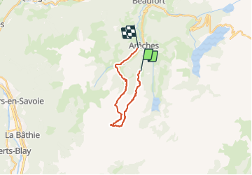
Ruta Esquí de fondo de 17,1 km a descubrir en Auvergne-Rhône-Alpes, Saboya, Beaufort. Esta ruta ha sido propuesta por FREERIDE13006.
Descripción
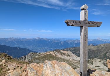
départ télésiège arrête beaufort ..ts Cluny... col de la forclaz...sommet du grand mont... descente combe nord..retour planay
Localización
País:
France
Región :
Auvergne-Rhône-Alpes
Departamento/provincia :
Saboya
Municipio :
Beaufort
Localidad:
Unknown
Salida:(Dec)
Salida:(UTM)
310393 ; 5060121 (32T) N.
Comentarios
Excursiones cerca
![Excursión Senderismo Beaufort - D'Arêches au Col de Pré par le hameau de Boudin - Photo](https://media.geolcdn.com/t/375/260/ext.jpg?maxdim=2&url=https%3A%2F%2Fservices.sitytrail.com%2FGeolivesWS%2FDownloadMedia.ashx%3FTrailID%3D112688%26Media%3D11533_5.jpg)
![Senderismo Senderismo](https://static1.geolcdn.com/sitytour/trail-icons/101.png)
D'Arêches au Col de Pré par le hameau de Boudin
Senderismo
Medio
(1)
Beaufort,
Auvergne-Rhône-Alpes,
Saboya,
France
![](/images/other/stat-length.png)
8,2 km | 17,9 km-effort
4h 0min
![](https://static1.geolcdn.com/siteimages/upload/files/16400158638029165_repeat_loop_refresh_sync_direction_icon.png)
Sí
![Excursión Senderismo Beaufort - Arêches Cuvy - Photo](https://media.geolcdn.com/t/375/260/ext.jpg?maxdim=2&url=https%3A%2F%2Fstatic1.geolcdn.com%2Fsiteimages%2Fupload%2Ffiles%2F1553511878bg_sport_marche.png)
![Senderismo Senderismo](https://static1.geolcdn.com/sitytour/trail-icons/101.png)
Arêches Cuvy
Senderismo
Medio
(1)
Beaufort,
Auvergne-Rhône-Alpes,
Saboya,
France
![](/images/other/stat-length.png)
7,1 km | 13,9 km-effort
2h 36min
![](https://static1.geolcdn.com/siteimages/upload/files/16400158638029165_repeat_loop_refresh_sync_direction_icon.png)
No
![Excursión Senderismo Beaufort - suuntoapp-Hiking-2024-09-07T06-03-31Z - Photo](https://media.geolcdn.com/t/375/260/1c7a5e77-787c-4d14-8dd4-f96128769e9c.jpg&format=jpg&maxdim=2)
![Senderismo Senderismo](https://static1.geolcdn.com/sitytour/trail-icons/101.png)
suuntoapp-Hiking-2024-09-07T06-03-31Z
Senderismo
Muy difícil
Beaufort,
Auvergne-Rhône-Alpes,
Saboya,
France
![](/images/other/stat-length.png)
21 km | 38 km-effort
8h 42min
![](https://static1.geolcdn.com/siteimages/upload/files/16400158638029165_repeat_loop_refresh_sync_direction_icon.png)
No
![Excursión Esquí de fondo Beaufort - Anticime de la pointe de la grande journée, montée couloir du grepets - Photo](https://media.geolcdn.com/t/375/260/8dfd1937-3bd4-42bd-a4fa-284d4bb8802e.jpg&format=jpg&maxdim=2)
![Esquí de fondo Esquí de fondo](https://static1.geolcdn.com/sitytour/trail-icons/503.png)
Anticime de la pointe de la grande journée, montée couloir du grepets
Esquí de fondo
Difícil
Beaufort,
Auvergne-Rhône-Alpes,
Saboya,
France
![](/images/other/stat-length.png)
13,4 km | 30 km-effort
4h 48min
![](https://static1.geolcdn.com/siteimages/upload/files/16400158638029165_repeat_loop_refresh_sync_direction_icon.png)
Sí
![Excursión Esquí de fondo Beaufort - Côte 2000 et col de Roche plane - Photo](https://media.geolcdn.com/t/375/260/38a11e49-5450-4382-89d2-44ae6ea43162.jpg&format=jpg&maxdim=2)
![Esquí de fondo Esquí de fondo](https://static1.geolcdn.com/sitytour/trail-icons/503.png)
Côte 2000 et col de Roche plane
Esquí de fondo
Fácil
Beaufort,
Auvergne-Rhône-Alpes,
Saboya,
France
![](/images/other/stat-length.png)
12,5 km | 29 km-effort
6h 46min
![](https://static1.geolcdn.com/siteimages/upload/files/16400158638029165_repeat_loop_refresh_sync_direction_icon.png)
Sí
![Excursión Senderismo Beaufort - Barrage St Guerin Refuge de l’Econdu 12 km - 600 m d’en + - Photo](https://media.geolcdn.com/t/375/260/e237980d-0989-4662-bd24-20be909d7e5b.jpg&format=jpg&maxdim=2)
![Senderismo Senderismo](https://static1.geolcdn.com/sitytour/trail-icons/101.png)
Barrage St Guerin Refuge de l’Econdu 12 km - 600 m d’en +
Senderismo
Medio
Beaufort,
Auvergne-Rhône-Alpes,
Saboya,
France
![](/images/other/stat-length.png)
11,9 km | 20 km-effort
5h 39min
![](https://static1.geolcdn.com/siteimages/upload/files/16400158638029165_repeat_loop_refresh_sync_direction_icon.png)
Sí
![Excursión Senderismo Beaufort - Le pas de l’âne 10 km 850 m dénivelé + - Photo](https://media.geolcdn.com/t/375/260/e16223c0-d24b-4318-beff-cfc74b9fa02c.jpg&format=jpg&maxdim=2)
![Senderismo Senderismo](https://static1.geolcdn.com/sitytour/trail-icons/101.png)
Le pas de l’âne 10 km 850 m dénivelé +
Senderismo
Medio
Beaufort,
Auvergne-Rhône-Alpes,
Saboya,
France
![](/images/other/stat-length.png)
10,2 km | 21 km-effort
7h 59min
![](https://static1.geolcdn.com/siteimages/upload/files/16400158638029165_repeat_loop_refresh_sync_direction_icon.png)
Sí
![Excursión Senderismo Beaufort - Roche Pastrire 8,7 km - Photo](https://media.geolcdn.com/t/375/260/783675ed-dc1c-4b41-82f9-ac57164bc294.jpg&format=jpg&maxdim=2)
![Senderismo Senderismo](https://static1.geolcdn.com/sitytour/trail-icons/101.png)
Roche Pastrire 8,7 km
Senderismo
Medio
Beaufort,
Auvergne-Rhône-Alpes,
Saboya,
France
![](/images/other/stat-length.png)
8,7 km | 15,3 km-effort
4h 23min
![](https://static1.geolcdn.com/siteimages/upload/files/16400158638029165_repeat_loop_refresh_sync_direction_icon.png)
Sí
![Excursión Senderismo Beaufort - Areches col du Pré version 11 km - Photo](https://media.geolcdn.com/t/375/260/7abc590a-8c82-46ce-b467-d226a059a885.jpg&format=jpg&maxdim=2)
![Senderismo Senderismo](https://static1.geolcdn.com/sitytour/trail-icons/101.png)
Areches col du Pré version 11 km
Senderismo
Medio
(1)
Beaufort,
Auvergne-Rhône-Alpes,
Saboya,
France
![](/images/other/stat-length.png)
11,2 km | 21 km-effort
7h 56min
![](https://static1.geolcdn.com/siteimages/upload/files/16400158638029165_repeat_loop_refresh_sync_direction_icon.png)
Sí