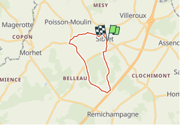
![](/images/other/stat-length.png)
![Excursión A pie Vaux-sur-Sûre - Promenade du Renard - Photo](https://media.geolcdn.com/t/1900/400/a4b7c189-2aa3-4341-b070-c509f488a2a0.jpeg&format=pjpeg&maxdim=2)
Promenade du Renard
SityTrail - itinéraires balisés pédestres
Tous les sentiers balisés d’Europe GUIDE+
![Longitud](/images/other/stat-length.png)
![Altitud máxima](https://static1.geolcdn.com/siteimages/upload/files/1508320355ic_sort_altitude_max_24dp.png)
![Desnivel positivo](https://static1.geolcdn.com/siteimages/upload/files/1508320355ic_sort_den_pos_24dp.png)
![Km-Effort](/images/other/stat-length.png)
![Altitud mínima](https://static1.geolcdn.com/siteimages/upload/files/1508320355ic_sort_altitude_min_24dp.png)
![Desnivel negativo](https://static1.geolcdn.com/siteimages/upload/files/1508320355ic_sort_den_neg_24dp.png)
![Boucle](https://static1.geolcdn.com/siteimages/upload/files/16400158638029165_repeat_loop_refresh_sync_direction_icon.png)
![A pie](https://static1.geolcdn.com/sitytour/trail-icons/100.png)
2h29
Dificultad : Fácil
![Escanee este código QR para abrir la excursión en la aplicación SityTrail](https://capi.geolives.com/qq0zvz2zws4bq2lad0pu/sitytour/trails/3085426/qr.png?size=200)
Aplicación GPS de excursión GRATIS
A propósito
Ruta A pie de 9 km a descubrir en Valonia, Luxemburgo, Vaux-sur-Sûre. Esta ruta ha sido propuesta por SityTrail - itinéraires balisés pédestres.
Descripción
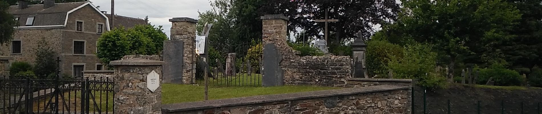
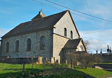
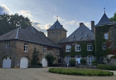
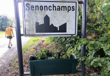
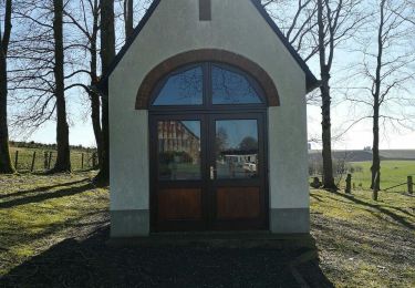
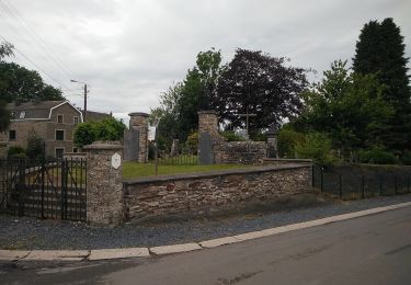
Vaux-sur-Sûre tire la fin de son nom de la rivière qui y prend sa source, la « Sûre ». La commune possède un patrimoine immobilier fourni à travers les villages et les hameaux où l’on ressent une âme rurale préservée. Plusieurs localités de Vaux peuvent aussi se targuer de posséder en leurs centres des églises imposantes au caractère original, qui contrastent avec les nombreuses chapelles éparpillées dans la campagne ardennaise environnante. Ancien cimetière de Sibret (commune de Vaux-sur-Sûre)
Sitio web: http://www.vaux-sur-sure-tourisme.be/promenade-renard
Localización
Comentarios
Excursiones cerca
![Excursión Senderismo Vaux-sur-Sûre - Hompré. Natura 2000, des sites qui valent le détour. Lx8 - Photo](https://media.geolcdn.com/t/375/260/ext.jpg?maxdim=2&url=https%3A%2F%2Fservices.sitytrail.com%2FGeolivesWS%2FDownloadMedia.ashx%3FTrailID%3D163750%26Media%3D9b92826d-7fd7-4872-9569-36ed8015d89e.jpg)
![Senderismo Senderismo](https://static1.geolcdn.com/sitytour/trail-icons/101.png)
Senderismo
![](/images/other/stat-length.png)
![](https://static1.geolcdn.com/siteimages/upload/files/16400158638029165_repeat_loop_refresh_sync_direction_icon.png)
![Excursión Senderismo Sainte-Ode - Magerotte - Promenade des Haies de Magery (T4) - Photo](https://media.geolcdn.com/t/375/260/ext.jpg?maxdim=2&url=https%3A%2F%2Fstatic1.geolcdn.com%2Fsiteimages%2Fupload%2Ffiles%2F1553511878bg_sport_marche.png)
![Senderismo Senderismo](https://static1.geolcdn.com/sitytour/trail-icons/101.png)
Senderismo
![](/images/other/stat-length.png)
![](https://static1.geolcdn.com/siteimages/upload/files/16400158638029165_repeat_loop_refresh_sync_direction_icon.png)
![Excursión Senderismo Sainte-Ode - Rechrival - Promenade des Haies des Valets (T3) - Photo](https://media.geolcdn.com/t/375/260/ext.jpg?maxdim=2&url=https%3A%2F%2Fstatic1.geolcdn.com%2Fsiteimages%2Fupload%2Ffiles%2F1553511878bg_sport_marche.png)
![Senderismo Senderismo](https://static1.geolcdn.com/sitytour/trail-icons/101.png)
Senderismo
![](/images/other/stat-length.png)
![](https://static1.geolcdn.com/siteimages/upload/files/16400158638029165_repeat_loop_refresh_sync_direction_icon.png)
![Excursión A pie Vaux-sur-Sûre - Promenade des Vanneaux - Photo](https://media.geolcdn.com/t/375/260/f25bda7f-df07-4cae-a9a3-cfe0c9000b2b.jpeg&format=jpg&maxdim=2)
![A pie A pie](https://static1.geolcdn.com/sitytour/trail-icons/100.png)
A pie
![](/images/other/stat-length.png)
![](https://static1.geolcdn.com/siteimages/upload/files/16400158638029165_repeat_loop_refresh_sync_direction_icon.png)
![Excursión Senderismo Bastoña - Bastogne - Photo](https://media.geolcdn.com/t/375/260/c8ea2498-5648-4f6f-9372-83bfe35ec759.jpg&format=jpg&maxdim=2)
![Senderismo Senderismo](https://static1.geolcdn.com/sitytour/trail-icons/101.png)
Senderismo
![](/images/other/stat-length.png)
![](https://static1.geolcdn.com/siteimages/upload/files/16400158638029165_repeat_loop_refresh_sync_direction_icon.png)
![Excursión Senderismo Bastoña - Marche 10 km 500 à Senonchamps. - Photo](https://media.geolcdn.com/t/375/260/5a88fca4-6ef8-4891-b167-25135544c6f2.jpg&format=jpg&maxdim=2)
![Senderismo Senderismo](https://static1.geolcdn.com/sitytour/trail-icons/101.png)
Senderismo
![](/images/other/stat-length.png)
![](https://static1.geolcdn.com/siteimages/upload/files/16400158638029165_repeat_loop_refresh_sync_direction_icon.png)
![Excursión A pie Vaux-sur-Sûre - Promenade de la Truite - Photo](https://media.geolcdn.com/t/375/260/dc8e6a7d-10c2-483c-849c-2c2e40a6aa00.jpeg&format=jpg&maxdim=2)
![A pie A pie](https://static1.geolcdn.com/sitytour/trail-icons/100.png)
A pie
![](/images/other/stat-length.png)
![](https://static1.geolcdn.com/siteimages/upload/files/16400158638029165_repeat_loop_refresh_sync_direction_icon.png)
![Excursión A pie Vaux-sur-Sûre - Promenade du Loup - Photo](https://media.geolcdn.com/t/375/260/a4b7c189-2aa3-4341-b070-c509f488a2a0.jpeg&format=jpg&maxdim=2)
![A pie A pie](https://static1.geolcdn.com/sitytour/trail-icons/100.png)
A pie
![](/images/other/stat-length.png)
![](https://static1.geolcdn.com/siteimages/upload/files/16400158638029165_repeat_loop_refresh_sync_direction_icon.png)
![Excursión A pie Vaux-sur-Sûre - Promenade du Renardeau - Photo](https://media.geolcdn.com/t/375/260/a4b7c189-2aa3-4341-b070-c509f488a2a0.jpeg&format=jpg&maxdim=2)
![A pie A pie](https://static1.geolcdn.com/sitytour/trail-icons/100.png)
A pie
![](/images/other/stat-length.png)
![](https://static1.geolcdn.com/siteimages/upload/files/16400158638029165_repeat_loop_refresh_sync_direction_icon.png)