![](/images/other/stat-length.png)
![Excursión A pie Wingene - Wildenburg wandelroute - Photo](https://media.geolcdn.com/t/1900/400/fd3079bb-35b7-49fc-8864-da1b40752982.jpeg&format=pjpeg&maxdim=2)
Wildenburg wandelroute
SityTrail - itinéraires balisés pédestres
Tous les sentiers balisés d’Europe GUIDE+
![Longitud](/images/other/stat-length.png)
Longitud
6,7 km
![Altitud máxima](https://static1.geolcdn.com/siteimages/upload/files/1508320355ic_sort_altitude_max_24dp.png)
Altitud máxima
34 m
![Desnivel positivo](https://static1.geolcdn.com/siteimages/upload/files/1508320355ic_sort_den_pos_24dp.png)
Desnivel positivo
78 m
![Km-Effort](/images/other/stat-length.png)
Km-Effort
7,8 km
![Altitud mínima](https://static1.geolcdn.com/siteimages/upload/files/1508320355ic_sort_altitude_min_24dp.png)
Altitud mínima
13 m
![Desnivel negativo](https://static1.geolcdn.com/siteimages/upload/files/1508320355ic_sort_den_neg_24dp.png)
Desnivel negativo
78 m
![Boucle](https://static1.geolcdn.com/siteimages/upload/files/16400158638029165_repeat_loop_refresh_sync_direction_icon.png)
Boucle
Sí
Baliza
Fecha de creación :
2022-02-09 15:07:50.991
Última modificación :
2022-02-09 17:54:07.28
![A pie](https://static1.geolcdn.com/sitytour/trail-icons/100.png)
1h45
Dificultad : Fácil
![Escanee este código QR para abrir la excursión en la aplicación SityTrail](https://capi.geolives.com/qq0zvz2zws4bq2lad0pu/sitytour/trails/3083358/qr.png?size=200)
Aplicación GPS de excursión GRATIS
A propósito
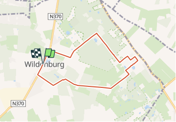
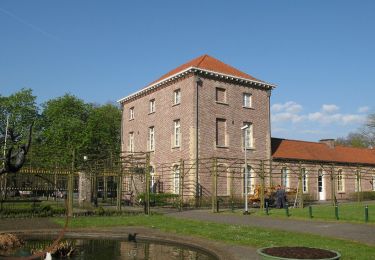
Ruta A pie de 6,7 km a descubrir en Flandes, Flandes Occidental, Wingene. Esta ruta ha sido propuesta por SityTrail - itinéraires balisés pédestres.
Descripción
De Wildenburgwandelroute gaat op verkenning in de omgeving van de Wingense wijk WIldenburg en het Ruiseleedse Sint-Pietersveld.
Localización
País:
Belgium
Región :
Flandes
Departamento/provincia :
Flandes Occidental
Municipio :
Wingene
Localidad:
Unknown
Salida:(Dec)
Salida:(UTM)
521501 ; 5659515 (31U) N.
Comentarios
Excursiones cerca
![Excursión A pie Wingene - Gulke Putten - Blauwe Wandeling - Photo](https://media.geolcdn.com/t/375/260/fd3079bb-35b7-49fc-8864-da1b40752982.jpeg&format=jpg&maxdim=2)
![A pie A pie](https://static1.geolcdn.com/sitytour/trail-icons/100.png)
Gulke Putten - Blauwe Wandeling
A pie
Fácil
Wingene,
Flandes,
Flandes Occidental,
Belgium
![](/images/other/stat-length.png)
7,3 km | 8 km-effort
1h 49min
![](https://static1.geolcdn.com/siteimages/upload/files/16400158638029165_repeat_loop_refresh_sync_direction_icon.png)
Sí
![Excursión A pie Beernem - Bulskampveldwandelroute - Photo](https://media.geolcdn.com/t/375/260/b6635d51-9eef-4271-bdb7-3c0b227bd424.jpeg&format=jpg&maxdim=2)
![A pie A pie](https://static1.geolcdn.com/sitytour/trail-icons/100.png)
Bulskampveldwandelroute
A pie
Fácil
Beernem,
Flandes,
Flandes Occidental,
Belgium
![](/images/other/stat-length.png)
8,7 km | 10,1 km-effort
2h 17min
![](https://static1.geolcdn.com/siteimages/upload/files/16400158638029165_repeat_loop_refresh_sync_direction_icon.png)
Sí
![Excursión Carrera Beernem - Bulskampveld - Photo](https://media.geolcdn.com/t/375/260/ext.jpg?maxdim=2&url=https%3A%2F%2Fstatic1.geolcdn.com%2Fsiteimages%2Fupload%2Ffiles%2F1524743154running.jpg)
![Carrera Carrera](https://static1.geolcdn.com/sitytour/trail-icons/103.png)
Bulskampveld
Carrera
Muy fácil
(1)
Beernem,
Flandes,
Flandes Occidental,
Belgium
![](/images/other/stat-length.png)
22 km | 25 km-effort
2h 45min
![](https://static1.geolcdn.com/siteimages/upload/files/16400158638029165_repeat_loop_refresh_sync_direction_icon.png)
Sí
![Excursión A pie Wingene - Gulke Putten - Rode Wandeling - Photo](https://media.geolcdn.com/t/375/260/5451753e-b4c5-4b69-854e-997059cec17e.jpeg&format=jpg&maxdim=2)
![A pie A pie](https://static1.geolcdn.com/sitytour/trail-icons/100.png)
Gulke Putten - Rode Wandeling
A pie
Fácil
Wingene,
Flandes,
Flandes Occidental,
Belgium
![](/images/other/stat-length.png)
5,5 km | 6,2 km-effort
1h 24min
![](https://static1.geolcdn.com/siteimages/upload/files/16400158638029165_repeat_loop_refresh_sync_direction_icon.png)
Sí
![Excursión A pie Aalter - De Vaanders - Photo](https://media.geolcdn.com/t/375/260/7b98d882-e8b6-4754-a8ea-80b25b0dfe97.jpeg&format=jpg&maxdim=2)
![A pie A pie](https://static1.geolcdn.com/sitytour/trail-icons/100.png)
De Vaanders
A pie
Fácil
Aalter,
Flandes,
Provincia de Flandes Oriental,
Belgium
![](/images/other/stat-length.png)
3,3 km | 3,7 km-effort
50min
![](https://static1.geolcdn.com/siteimages/upload/files/16400158638029165_repeat_loop_refresh_sync_direction_icon.png)
Sí
![Excursión A pie Ruiselede - Parochieveld - Photo](https://media.geolcdn.com/t/375/260/16aa5487-e3ce-4aa4-b097-c8d037abfa3e.jpeg&format=jpg&maxdim=2)
![A pie A pie](https://static1.geolcdn.com/sitytour/trail-icons/100.png)
Parochieveld
A pie
Fácil
Ruiselede,
Flandes,
Flandes Occidental,
Belgium
![](/images/other/stat-length.png)
8,4 km | 9,5 km-effort
2h 9min
![](https://static1.geolcdn.com/siteimages/upload/files/16400158638029165_repeat_loop_refresh_sync_direction_icon.png)
Sí
![Excursión Caballo Beernem - bulskampveld - Photo](https://media.geolcdn.com/t/375/260/ext.jpg?maxdim=2&url=https%3A%2F%2Fservices.sitytrail.com%2FGeolivesWS%2FDownloadMedia.ashx%3FTrailID%3D632737%26Media%3D20160918142252.jpg)
![Caballo Caballo](https://static1.geolcdn.com/sitytour/trail-icons/300.png)
bulskampveld
Caballo
Muy fácil
Beernem,
Flandes,
Flandes Occidental,
Belgium
![](/images/other/stat-length.png)
21 km | 25 km-effort
2h 30min
![](https://static1.geolcdn.com/siteimages/upload/files/16400158638029165_repeat_loop_refresh_sync_direction_icon.png)
Sí
![Excursión Senderismo Beernem - GR 129 : Beernem > Aalter - Photo](https://media.geolcdn.com/t/375/260/ext.jpg?maxdim=2&url=https%3A%2F%2Fstatic1.geolcdn.com%2Fsiteimages%2Fupload%2Ffiles%2F1553511878bg_sport_marche.png)
![Senderismo Senderismo](https://static1.geolcdn.com/sitytour/trail-icons/101.png)
GR 129 : Beernem > Aalter
Senderismo
Muy fácil
Beernem,
Flandes,
Flandes Occidental,
Belgium
![](/images/other/stat-length.png)
26 km | 29 km-effort
6h 17min
![](https://static1.geolcdn.com/siteimages/upload/files/16400158638029165_repeat_loop_refresh_sync_direction_icon.png)
No
![Excursión Senderismo Oostkamp - Belgie - Wandeling Hertsberge bossen - Photo](https://media.geolcdn.com/t/375/260/ext.jpg?maxdim=2&url=https%3A%2F%2Fstatic1.geolcdn.com%2Fsiteimages%2Fupload%2Ffiles%2F1553511878bg_sport_marche.png)
![Senderismo Senderismo](https://static1.geolcdn.com/sitytour/trail-icons/101.png)
Belgie - Wandeling Hertsberge bossen
Senderismo
Muy fácil
Oostkamp,
Flandes,
Flandes Occidental,
Belgium
![](/images/other/stat-length.png)
9,3 km | 10,5 km-effort
Desconocido
![](https://static1.geolcdn.com/siteimages/upload/files/16400158638029165_repeat_loop_refresh_sync_direction_icon.png)
Sí