![](/images/other/stat-length.png)
![Excursión A pie Liedekerke - Tweedorpenwandeling - Photo](https://media.geolcdn.com/t/1900/400/318adc88-016f-4533-ab78-8de83420931e.jpeg&format=pjpeg&maxdim=2)
Tweedorpenwandeling
SityTrail - itinéraires balisés pédestres
Tous les sentiers balisés d’Europe GUIDE+
![Longitud](/images/other/stat-length.png)
Longitud
9,5 km
![Altitud máxima](https://static1.geolcdn.com/siteimages/upload/files/1508320355ic_sort_altitude_max_24dp.png)
Altitud máxima
44 m
![Desnivel positivo](https://static1.geolcdn.com/siteimages/upload/files/1508320355ic_sort_den_pos_24dp.png)
Desnivel positivo
81 m
![Km-Effort](/images/other/stat-length.png)
Km-Effort
10,6 km
![Altitud mínima](https://static1.geolcdn.com/siteimages/upload/files/1508320355ic_sort_altitude_min_24dp.png)
Altitud mínima
9 m
![Desnivel negativo](https://static1.geolcdn.com/siteimages/upload/files/1508320355ic_sort_den_neg_24dp.png)
Desnivel negativo
82 m
![Boucle](https://static1.geolcdn.com/siteimages/upload/files/16400158638029165_repeat_loop_refresh_sync_direction_icon.png)
Boucle
Sí
Baliza
Fecha de creación :
2022-02-09 14:24:02.763
Última modificación :
2022-02-09 17:52:33.063
![A pie](https://static1.geolcdn.com/sitytour/trail-icons/100.png)
2h24
Dificultad : Fácil
![Escanee este código QR para abrir la excursión en la aplicación SityTrail](https://capi.geolives.com/qq0zvz2zws4bq2lad0pu/sitytour/trails/3083095/qr.png?size=200)
Aplicación GPS de excursión GRATIS
A propósito
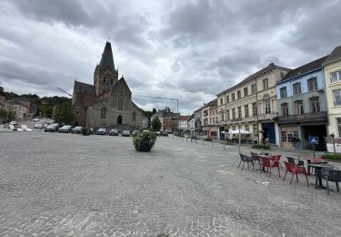
Ruta A pie de 9,5 km a descubrir en Flandes, Brabante Flamenco, Liedekerke. Esta ruta ha sido propuesta por SityTrail - itinéraires balisés pédestres.
Descripción
Trail created by Toerisme Vlaams-Brabant.
Localización
País:
Belgium
Región :
Flandes
Departamento/provincia :
Brabante Flamenco
Municipio :
Liedekerke
Localidad:
Unknown
Salida:(Dec)
Salida:(UTM)
575979 ; 5635211 (31U) N.
Comentarios
Excursiones cerca
![Excursión Senderismo Denderleeuw - Liedekerke 15,6 km - Photo](https://media.geolcdn.com/t/375/260/98d72d1f-a0f9-48f7-86c8-4e8051be6d6c.jpg&format=jpg&maxdim=2)
![Senderismo Senderismo](https://static1.geolcdn.com/sitytour/trail-icons/101.png)
Liedekerke 15,6 km
Senderismo
Medio
Denderleeuw,
Flandes,
Provincia de Flandes Oriental,
Belgium
![](/images/other/stat-length.png)
15,6 km | 17,3 km-effort
4h 33min
![](https://static1.geolcdn.com/siteimages/upload/files/16400158638029165_repeat_loop_refresh_sync_direction_icon.png)
Sí
![Excursión Senderismo Ninove - Ninove Geraardsbergen 28 km - Photo](https://media.geolcdn.com/t/375/260/719485f2-f85f-49bd-9431-7471732f52c8.jpg&format=jpg&maxdim=2)
![Senderismo Senderismo](https://static1.geolcdn.com/sitytour/trail-icons/101.png)
Ninove Geraardsbergen 28 km
Senderismo
Medio
Ninove,
Flandes,
Provincia de Flandes Oriental,
Belgium
![](/images/other/stat-length.png)
28 km | 33 km-effort
7h 42min
![](https://static1.geolcdn.com/siteimages/upload/files/16400158638029165_repeat_loop_refresh_sync_direction_icon.png)
No
![Excursión Senderismo Lennik - schaekens Ternat kapel - Photo](https://media.geolcdn.com/t/375/260/789b059d-25db-44ac-87e2-3aa7417a3c24.jpg&format=jpg&maxdim=2)
![Senderismo Senderismo](https://static1.geolcdn.com/sitytour/trail-icons/101.png)
schaekens Ternat kapel
Senderismo
Muy fácil
Lennik,
Flandes,
Brabante Flamenco,
Belgium
![](/images/other/stat-length.png)
12 km | 13,3 km-effort
2h 50min
![](https://static1.geolcdn.com/siteimages/upload/files/16400158638029165_repeat_loop_refresh_sync_direction_icon.png)
No
![Excursión Senderismo Liedekerke - 20221030 WSV De Pajotten 7 km - Photo](https://media.geolcdn.com/t/375/260/619ccd8b-37bf-4bb2-bd6b-1aa4135295ac.jpg&format=jpg&maxdim=2)
![Senderismo Senderismo](https://static1.geolcdn.com/sitytour/trail-icons/101.png)
20221030 WSV De Pajotten 7 km
Senderismo
Medio
Liedekerke,
Flandes,
Brabante Flamenco,
Belgium
![](/images/other/stat-length.png)
7 km | 7,8 km-effort
1h 28min
![](https://static1.geolcdn.com/siteimages/upload/files/16400158638029165_repeat_loop_refresh_sync_direction_icon.png)
Sí
![Excursión Senderismo Roosdaal - 2022 03 26 Tocht maart - Photo](https://media.geolcdn.com/t/375/260/0fae5cd3-6fe9-4715-8f25-2bbf0633d9da.jpg&format=jpg&maxdim=2)
![Senderismo Senderismo](https://static1.geolcdn.com/sitytour/trail-icons/101.png)
2022 03 26 Tocht maart
Senderismo
Medio
Roosdaal,
Flandes,
Brabante Flamenco,
Belgium
![](/images/other/stat-length.png)
8,2 km | 9,5 km-effort
1h 43min
![](https://static1.geolcdn.com/siteimages/upload/files/16400158638029165_repeat_loop_refresh_sync_direction_icon.png)
Sí
![Excursión Senderismo Denderleeuw - verkenning welle schotte - Photo](https://media.geolcdn.com/t/375/260/52bdeba9-7146-446f-8a3e-3ef2ece3c863.jpg&format=jpg&maxdim=2)
![Senderismo Senderismo](https://static1.geolcdn.com/sitytour/trail-icons/101.png)
verkenning welle schotte
Senderismo
Fácil
Denderleeuw,
Flandes,
Provincia de Flandes Oriental,
Belgium
![](/images/other/stat-length.png)
2,7 km | 2,9 km-effort
31min
![](https://static1.geolcdn.com/siteimages/upload/files/16400158638029165_repeat_loop_refresh_sync_direction_icon.png)
No
![Excursión Senderismo Roosdaal - OLVrouw Lombeek (Roosdaal) - Windmolen - Photo](https://media.geolcdn.com/t/375/260/ext.jpg?maxdim=2&url=https%3A%2F%2Fstatic1.geolcdn.com%2Fsiteimages%2Fupload%2Ffiles%2F1553511878bg_sport_marche.png)
![Senderismo Senderismo](https://static1.geolcdn.com/sitytour/trail-icons/101.png)
OLVrouw Lombeek (Roosdaal) - Windmolen
Senderismo
Fácil
Roosdaal,
Flandes,
Brabante Flamenco,
Belgium
![](/images/other/stat-length.png)
9,4 km | 10,6 km-effort
2h 45min
![](https://static1.geolcdn.com/siteimages/upload/files/16400158638029165_repeat_loop_refresh_sync_direction_icon.png)
Sí
![Excursión Senderismo Ninove - rondje met de hond Meerbeke bunkers - Photo](https://media.geolcdn.com/t/375/260/ext.jpg?maxdim=2&url=https%3A%2F%2Fstatic1.geolcdn.com%2Fsiteimages%2Fupload%2Ffiles%2F1553511878bg_sport_marche.png)
![Senderismo Senderismo](https://static1.geolcdn.com/sitytour/trail-icons/101.png)
rondje met de hond Meerbeke bunkers
Senderismo
Muy fácil
Ninove,
Flandes,
Provincia de Flandes Oriental,
Belgium
![](/images/other/stat-length.png)
4,6 km | 5,1 km-effort
1h 37min
![](https://static1.geolcdn.com/siteimages/upload/files/16400158638029165_repeat_loop_refresh_sync_direction_icon.png)
Sí
![Excursión Senderismo Ninove - rondje met hondje in Ninove - Photo](https://media.geolcdn.com/t/375/260/ext.jpg?maxdim=2&url=https%3A%2F%2Fstatic1.geolcdn.com%2Fsiteimages%2Fupload%2Ffiles%2F1553511878bg_sport_marche.png)
![Senderismo Senderismo](https://static1.geolcdn.com/sitytour/trail-icons/101.png)
rondje met hondje in Ninove
Senderismo
Muy fácil
Ninove,
Flandes,
Provincia de Flandes Oriental,
Belgium
![](/images/other/stat-length.png)
6 km | 6,6 km-effort
1h 40min
![](https://static1.geolcdn.com/siteimages/upload/files/16400158638029165_repeat_loop_refresh_sync_direction_icon.png)
No