![](/images/other/stat-length.png)
![Excursión A pie Andenne - Siroux - Photo](https://media.geolcdn.com/t/1900/400/ext.pjpeg?maxdim=2&url=https%3A%2F%2Fpivotmedia.tourismewallonie.be%2FOTH-A0-0063-0TBL%2FOTH-A0-0063-0TBL.jpg)
Siroux
Commissariat général au Tourisme
Randonnées du CGT GUIDE+
![Longitud](/images/other/stat-length.png)
![Altitud máxima](https://static1.geolcdn.com/siteimages/upload/files/1508320355ic_sort_altitude_max_24dp.png)
![Desnivel positivo](https://static1.geolcdn.com/siteimages/upload/files/1508320355ic_sort_den_pos_24dp.png)
![Km-Effort](/images/other/stat-length.png)
![Altitud mínima](https://static1.geolcdn.com/siteimages/upload/files/1508320355ic_sort_altitude_min_24dp.png)
![Desnivel negativo](https://static1.geolcdn.com/siteimages/upload/files/1508320355ic_sort_den_neg_24dp.png)
![Boucle](https://static1.geolcdn.com/siteimages/upload/files/16400158638029165_repeat_loop_refresh_sync_direction_icon.png)
![A pie](https://static1.geolcdn.com/sitytour/trail-icons/100.png)
2h00
Dificultad : Fácil
![Escanee este código QR para abrir la excursión en la aplicación SityTrail](https://capi.geolives.com/qq0zvz2zws4bq2lad0pu/sitytour/trails/3080060/qr.png?size=200)
Aplicación GPS de excursión GRATIS
A propósito
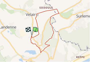
Ruta A pie de 6,9 km a descubrir en Valonia, Namur, Andenne. Esta ruta ha sido propuesta por Commissariat général au Tourisme.
Descripción
Trail created by Vallée de la Meuse Namur-Dinant.
This 7 km walk takes you to the heights of the village of Seilles and the Royal Wood of Siroux.
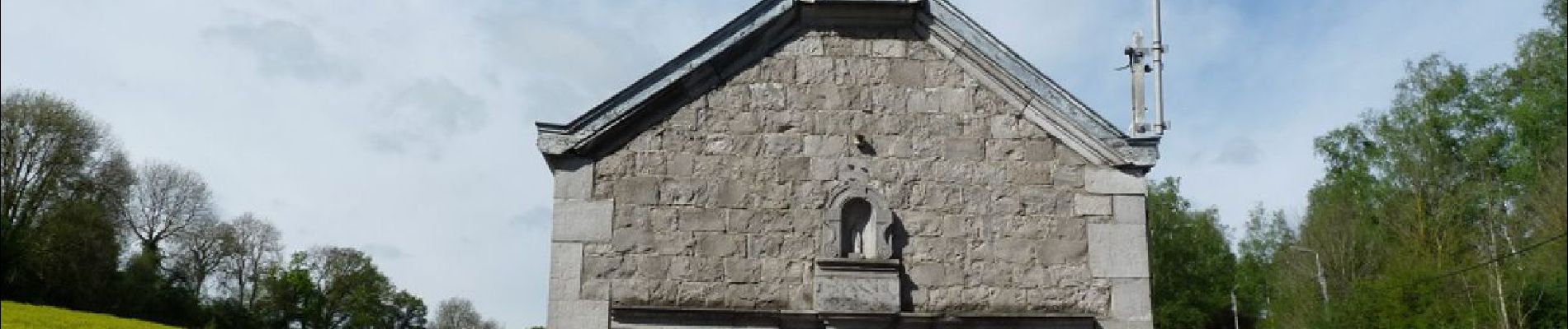
You start your walk through the small streets of the hamlet of Poilsart before joining a path in the fields that leads you to the hamlet of Velaine. Once there, you follow several country roads to the Bois de la Ronde Haie where you cross the Velaine river. You continue through the woods on nice dirt roads. You will arrive at the Royal Wood of Siroux. At the end of your crossing, you cross again the Velaine, partly canalized. You then return to the roadway, which you cross carefully to discover this time the paths of the Seillois countryside. They take you to the very charming Notre-Dame du Bon Secours chapel, in the immediate vicinity of the Rue de Tramaka. You cross the road again to finally reach your starting point.
Localización
Comentarios
Excursiones cerca
![Senderismo Senderismo](https://static1.geolcdn.com/sitytour/trail-icons/101.png)
Senderismo
![](/images/other/stat-length.png)
![](https://static1.geolcdn.com/siteimages/upload/files/16400158638029165_repeat_loop_refresh_sync_direction_icon.png)
![Excursión Senderismo Andenne - Balade dans la Réserve Naturelle de Sclaigneaux - Andenne - Photo](https://media.geolcdn.com/t/375/260/ext.jpg?maxdim=2&url=https%3A%2F%2Fservices.sitytrail.com%2FGeolivesWS%2FDownloadMedia.ashx%3FTrailID%3D364407%26Media%3D25ebe739-f8f0-42c8-9053-a62d25d6f679.JPG)
![Senderismo Senderismo](https://static1.geolcdn.com/sitytour/trail-icons/101.png)
Senderismo
![](/images/other/stat-length.png)
![](https://static1.geolcdn.com/siteimages/upload/files/16400158638029165_repeat_loop_refresh_sync_direction_icon.png)
![Excursión Senderismo Andenne - La Randonnée des Aguesses - Photo](https://media.geolcdn.com/t/375/260/ext.jpg?maxdim=2&url=https%3A%2F%2Fservices.sitytrail.com%2FGeolivesWS%2FDownloadMedia.ashx%3FTrailID%3D272048%26Media%3D01b80513-5036-477c-b953-e76e9f4a383c.jpg)
![Senderismo Senderismo](https://static1.geolcdn.com/sitytour/trail-icons/101.png)
Senderismo
![](/images/other/stat-length.png)
![](https://static1.geolcdn.com/siteimages/upload/files/16400158638029165_repeat_loop_refresh_sync_direction_icon.png)
![Excursión Bici de montaña Andenne - Chaine en Chêne 2012 - 50 km - Photo](https://media.geolcdn.com/t/375/260/ext.jpg?maxdim=2&url=https%3A%2F%2Fservices.sitytrail.com%2FGeolivesWS%2FDownloadMedia.ashx%3FTrailID%3D272023%26Media%3D7f9d6905-0c15-4063-b5ec-f25b4073c8bd.jpg)
![Bici de montaña Bici de montaña](https://static1.geolcdn.com/sitytour/trail-icons/202.png)
Bici de montaña
![](/images/other/stat-length.png)
![](https://static1.geolcdn.com/siteimages/upload/files/16400158638029165_repeat_loop_refresh_sync_direction_icon.png)
![Excursión Bici de montaña Andenne - Chaine en Chêne 2011 - 40km - Photo](https://media.geolcdn.com/t/375/260/ext.jpg?maxdim=2&url=https%3A%2F%2Fservices.sitytrail.com%2FGeolivesWS%2FDownloadMedia.ashx%3FTrailID%3D272014%26Media%3D3b21c47e-3f43-42be-b476-00028f6a358a.jpg)
![Bici de montaña Bici de montaña](https://static1.geolcdn.com/sitytour/trail-icons/202.png)
Bici de montaña
![](/images/other/stat-length.png)
![](https://static1.geolcdn.com/siteimages/upload/files/16400158638029165_repeat_loop_refresh_sync_direction_icon.png)
![Excursión Bici de montaña Andenne - Chaine en Chêne 2012 - 30km - Photo](https://media.geolcdn.com/t/375/260/ext.jpg?maxdim=2&url=https%3A%2F%2Fservices.sitytrail.com%2FGeolivesWS%2FDownloadMedia.ashx%3FTrailID%3D272013%26Media%3Debbce068-43b4-47e0-810f-fab4cc8f25f4.jpg)
![Bici de montaña Bici de montaña](https://static1.geolcdn.com/sitytour/trail-icons/202.png)
Bici de montaña
![](/images/other/stat-length.png)
![](https://static1.geolcdn.com/siteimages/upload/files/16400158638029165_repeat_loop_refresh_sync_direction_icon.png)
![Excursión Senderismo Héron - Promenade des châteaux (Couthuin) - Photo](https://media.geolcdn.com/t/375/260/d580117c-a9d5-4ac9-a44f-0f59b38e05c1.jpg&format=jpg&maxdim=2)
![Senderismo Senderismo](https://static1.geolcdn.com/sitytour/trail-icons/101.png)
Senderismo
![](/images/other/stat-length.png)
![](https://static1.geolcdn.com/siteimages/upload/files/16400158638029165_repeat_loop_refresh_sync_direction_icon.png)
![Senderismo Senderismo](https://static1.geolcdn.com/sitytour/trail-icons/101.png)
Senderismo
![](/images/other/stat-length.png)
![](https://static1.geolcdn.com/siteimages/upload/files/16400158638029165_repeat_loop_refresh_sync_direction_icon.png)
![Excursión Senderismo Andenne - ANDENNE _ Salle Polyvalente _ Site Godin _ Rue Malevé _ 5300 ANDENNE - Photo](https://media.geolcdn.com/t/375/260/7e46220f-fd86-45d4-ae4c-a6f00ad2385f.jpg&format=jpg&maxdim=2)
![Senderismo Senderismo](https://static1.geolcdn.com/sitytour/trail-icons/101.png)
Senderismo
![](/images/other/stat-length.png)
![](https://static1.geolcdn.com/siteimages/upload/files/16400158638029165_repeat_loop_refresh_sync_direction_icon.png)