Excursión A pie Andenne - Randonnée des Arches Royales - Photo

Randonnée des Arches Royales

Randonnées du CGT GUIDE+

© OpenStreetMap contributors
Longitud
Longitud
10,7 km
Altitud máxima
Altitud máxima
254 m
Desnivel positivo
Desnivel positivo
287 m
Km-Effort
Km-Effort  
14,6 km
Altitud mínima
Altitud mínima
123 m
Desnivel negativo
Desnivel negativo
290 m
Boucle
Boucle
Fecha de creación :
2022-02-08 11:21:32.861
Última modificación :
2022-02-21 10:02:33.86

(0 Opinión)

A pie
A pie
3h18
Dificultad : Fácil

Escanee este código QR para abrir la excursión en la aplicación SityTrail

Aplicación GPS de excursión GRATIS

Logo SityTrail SityTrail

IGN / Institutos geográficos

Descargar SityTrail en App Store Descargar SityTrail en Google Play

Logo SityTrail SityTrail World

El mundo es suyo

Descargar SityTrail en App Store Descargar SityTrail en Google Play Descargar SityTrail en Huawei AppGallery

A propósito

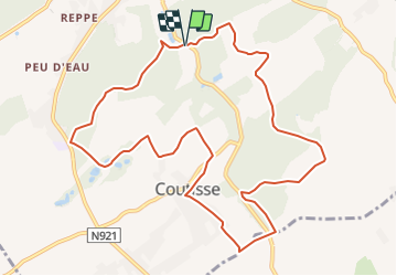
Ruta A pie de 10,7 km a descubrir en Valonia, Namur, Andenne. Esta ruta ha sido propuesta por Commissariat général au Tourisme.

Descripción

Trail created by Vallée de la Meuse Namur-Dinant.


This 10km hike starts in the immediate vicinity of the picturesque Moulin de Kevret and takes you to discover the countryside and woods around the village of Coutisse.


You start by climbing in the Bois de Paspau to reach the hamlet of Grosse and its majestic Farm. You then continue through the fields to the Bois des Arches. Do not hesitate to make a small detour to the charming Ferme des Arches Royales. After a new passage through the wood, you pass the hamlet of Treton where you cross the road to join the other side of the valley. After a passage in the village of Coutisse, you join the small paths and you pass along the old Farm of the Cross. You continue through the fields and cross a small ford on the Fond des Vaux stream. You then take a path rehabilitated by the walking group Les Nomades Épicuriens. Just after passing through the place called Grande Croix, you will see the beautiful Ferme de Leumont. The last part of the walk takes you back to the Bois d'Heer, where you will discover the place called Lionfontaine before returning to the Moulin de Kevret, your starting point.


Perfil altimétrico

Fotos

Localización

País:
Belgium
Región :
Valonia
Departamento/provincia :
Namur
Municipio :
Andenne
Localidad:
Unknown
Salida:(UTM)
650181 ; 5593917 (31U) N.

Excursiones cerca

Excursión Senderismo Andenne - RB-Na-17-Au pays de Sainte-Begge - Photo
Senderismo
PRO

Senderismo

Muy difícil
(13)
Andenne, Valonia, Namur, Belgium
17,8 km | 23 km-effort
5h 18min
Excursión Senderismo Ohey - OHEY- Haillot- N°12-Bois  - Photo
Senderismo
PRO

Senderismo

Fácil
(5)
Ohey, Valonia, Namur, Belgium
6,6 km | 7,9 km-effort
1h 42min
Excursión Senderismo Gesves - Sentiers d'art : Boucle 11- Haltinne - Photo
Senderismo
PRO

Senderismo

Fácil
(6)
Gesves, Valonia, Namur, Belgium
9,6 km | 11,8 km-effort
2h 0min
Excursión Senderismo Ohey - Promenade des Petits Ponts- Bois d'Ohey - Photo
Senderismo
PRO

Senderismo

Medio
(7)
Ohey, Valonia, Namur, Belgium
6,2 km | 7,4 km-effort
1h 38min
Excursión Senderismo Andenne - La Randonnée des Aguesses - Photo
Senderismo
GUIDE+

Senderismo

Fácil
(2)
Andenne, Valonia, Namur, Belgium
7,4 km | 9,7 km-effort
2h 8min
Excursión Bici de montaña Andenne - Chaine en Chêne 2012 - 50 km - Photo
Bici de montaña
GUIDE+

Bici de montaña

Difícil
(1)
Andenne, Valonia, Namur, Belgium
50 km | 65 km-effort
1h 44min
Excursión Bici de montaña Andenne - Chaine en Chêne 2011 - 40km - Photo
Bici de montaña
GUIDE+

Bici de montaña

Difícil
(1)
Andenne, Valonia, Namur, Belgium
37 km | 47 km-effort
3h 0min
Excursión Bici de montaña Andenne - Chaine en Chêne 2012 - 30km - Photo
Bici de montaña
GUIDE+

Bici de montaña

Difícil
(1)
Andenne, Valonia, Namur, Belgium
30 km | 38 km-effort
2h 28min
Excursión Senderismo Gesves - OHEY- REPPE- N°11-Biodiversité  - Photo
Senderismo
PRO

Senderismo

Fácil
(4)
Gesves, Valonia, Namur, Belgium
10,6 km | 12,3 km-effort
2h 41min


Cerrar
Mis suscripciones