![](/images/other/stat-length.png)
![Excursión Senderismo Dortan - Boucle sur les hauteurs de Dortan - Photo](https://media.geolcdn.com/t/1900/400/ee5d509c-2a81-4e42-9bbc-67adf4dcc2b1.jpg&format=pjpeg&maxdim=2)
Boucle sur les hauteurs de Dortan
zefreefly
Usuario
![Longitud](/images/other/stat-length.png)
Longitud
18,1 km
![Altitud máxima](https://static1.geolcdn.com/siteimages/upload/files/1508320355ic_sort_altitude_max_24dp.png)
Altitud máxima
718 m
![Desnivel positivo](https://static1.geolcdn.com/siteimages/upload/files/1508320355ic_sort_den_pos_24dp.png)
Desnivel positivo
718 m
![Km-Effort](/images/other/stat-length.png)
Km-Effort
28 km
![Altitud mínima](https://static1.geolcdn.com/siteimages/upload/files/1508320355ic_sort_altitude_min_24dp.png)
Altitud mínima
371 m
![Desnivel negativo](https://static1.geolcdn.com/siteimages/upload/files/1508320355ic_sort_den_neg_24dp.png)
Desnivel negativo
729 m
![Boucle](https://static1.geolcdn.com/siteimages/upload/files/16400158638029165_repeat_loop_refresh_sync_direction_icon.png)
Boucle
Sí
Fecha de creación :
2022-02-04 07:49:12.0
Última modificación :
2022-02-04 14:09:37.605
![Senderismo](https://static1.geolcdn.com/sitytour/trail-icons/101.png)
4h35
Dificultad : Medio
![Escanee este código QR para abrir la excursión en la aplicación SityTrail](https://capi.geolives.com/qq0zvz2zws4bq2lad0pu/sitytour/trails/3075577/qr.png?size=200)
Aplicación GPS de excursión GRATIS
A propósito
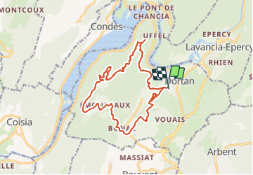
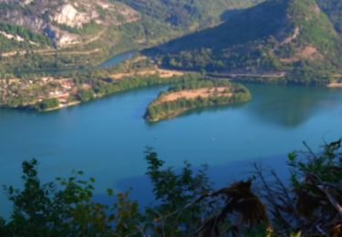
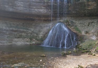
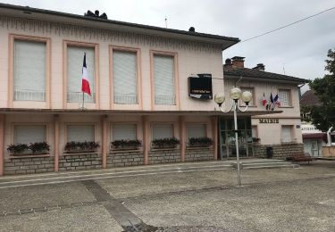
Ruta Senderismo de 18,1 km a descubrir en Auvergne-Rhône-Alpes, Ain, Dortan. Esta ruta ha sido propuesta por zefreefly.
Descripción
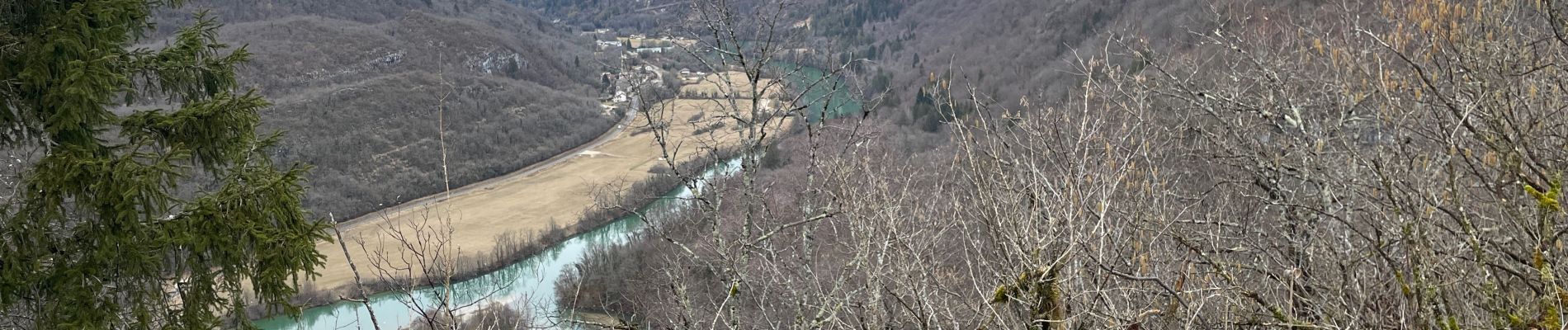
De la grimpette du chemin forestier et pas trop de bitume.
Bien balisé avec une atmosphère particulière dans la forêt cette Rando en boucle est agréable et sportive avec un petit passage sécurisé.
Cette trace quitte le balisage sur 1 km
Localización
País:
France
Región :
Auvergne-Rhône-Alpes
Departamento/provincia :
Ain
Municipio :
Dortan
Localidad:
Unknown
Salida:(Dec)
Salida:(UTM)
704320 ; 5132618 (31T) N.
Comentarios
Excursiones cerca
![Excursión Senderismo Viry - Haut Jura - Giron - Viry - Photo](https://media.geolcdn.com/t/375/260/ext.jpg?maxdim=2&url=https%3A%2F%2Fservices.sitytrail.com%2FGeolivesWS%2FDownloadMedia.ashx%3FTrailID%3D109575%26Media%3D4201_1.jpg)
![Senderismo Senderismo](https://static1.geolcdn.com/sitytour/trail-icons/101.png)
Haut Jura - Giron - Viry
Senderismo
Difícil
(1)
Viry,
Borgoña-Franco Condado,
Jura,
France
![](/images/other/stat-length.png)
25 km | 37 km-effort
6h 0min
![](https://static1.geolcdn.com/siteimages/upload/files/16400158638029165_repeat_loop_refresh_sync_direction_icon.png)
No
![Excursión Senderismo Dortan - dortan - Photo](https://media.geolcdn.com/t/375/260/92b3033b-7712-4a3b-9007-597555739d0c.jpg&format=jpg&maxdim=2)
![Senderismo Senderismo](https://static1.geolcdn.com/sitytour/trail-icons/101.png)
dortan
Senderismo
Fácil
Dortan,
Auvergne-Rhône-Alpes,
Ain,
France
![](/images/other/stat-length.png)
12 km | 15,6 km-effort
3h 37min
![](https://static1.geolcdn.com/siteimages/upload/files/16400158638029165_repeat_loop_refresh_sync_direction_icon.png)
Sí
![Excursión Senderismo Dortan - col de la Tendue pierre qui vire - Photo](https://media.geolcdn.com/t/375/260/58a49901-ab7e-49f1-b0d0-8b7cb0f7204a.jpg&format=jpg&maxdim=2)
![Senderismo Senderismo](https://static1.geolcdn.com/sitytour/trail-icons/101.png)
col de la Tendue pierre qui vire
Senderismo
Difícil
Dortan,
Auvergne-Rhône-Alpes,
Ain,
France
![](/images/other/stat-length.png)
9,2 km | 15,5 km-effort
2h 51min
![](https://static1.geolcdn.com/siteimages/upload/files/16400158638029165_repeat_loop_refresh_sync_direction_icon.png)
Sí
![Excursión Senderismo Dortan - vouais. la pierre qui vire.la cascade de la combe. - Photo](https://media.geolcdn.com/t/375/260/5f8b3633-bbf6-4a49-948c-9315092f03da.jpg&format=jpg&maxdim=2)
![Senderismo Senderismo](https://static1.geolcdn.com/sitytour/trail-icons/101.png)
vouais. la pierre qui vire.la cascade de la combe.
Senderismo
Fácil
Dortan,
Auvergne-Rhône-Alpes,
Ain,
France
![](/images/other/stat-length.png)
10 km | 14,7 km-effort
2h 51min
![](https://static1.geolcdn.com/siteimages/upload/files/16400158638029165_repeat_loop_refresh_sync_direction_icon.png)
Sí
![Excursión A pie Dortan - La Pierre qui vire - Photo](https://media.geolcdn.com/t/375/260/3e210a43-ea7d-498b-a5d8-2880f86b08ad.jpeg&format=jpg&maxdim=2)
![A pie A pie](https://static1.geolcdn.com/sitytour/trail-icons/100.png)
La Pierre qui vire
A pie
Fácil
Dortan,
Auvergne-Rhône-Alpes,
Ain,
France
![](/images/other/stat-length.png)
3,1 km | 6,1 km-effort
1h 23min
![](https://static1.geolcdn.com/siteimages/upload/files/16400158638029165_repeat_loop_refresh_sync_direction_icon.png)
No
![Excursión Senderismo Viry - Siege - Photo](https://media.geolcdn.com/t/375/260/77dd9ca0-0f8d-47ce-a347-2eb0ba0a304b.jpg&format=jpg&maxdim=2)
![Senderismo Senderismo](https://static1.geolcdn.com/sitytour/trail-icons/101.png)
Siege
Senderismo
Medio
Viry,
Borgoña-Franco Condado,
Jura,
France
![](/images/other/stat-length.png)
7,6 km | 11,5 km-effort
2h 28min
![](https://static1.geolcdn.com/siteimages/upload/files/16400158638029165_repeat_loop_refresh_sync_direction_icon.png)
Sí
![Excursión Senderismo Dortan - vouais - Photo](https://media.geolcdn.com/t/375/260/8c0e39ff-f905-4874-b772-0eca47f74074.jpg&format=jpg&maxdim=2)
![Senderismo Senderismo](https://static1.geolcdn.com/sitytour/trail-icons/101.png)
vouais
Senderismo
Difícil
Dortan,
Auvergne-Rhône-Alpes,
Ain,
France
![](/images/other/stat-length.png)
14,3 km | 22 km-effort
7h 11min
![](https://static1.geolcdn.com/siteimages/upload/files/16400158638029165_repeat_loop_refresh_sync_direction_icon.png)
Sí
![Excursión Senderismo Dortan - dortan .la pierre qui vire .les 3 dammetes et retour dortant retour - Photo](https://media.geolcdn.com/t/375/260/02535d49-f093-484f-bd82-a87ac69d8bc7.jpg&format=jpg&maxdim=2)
![Senderismo Senderismo](https://static1.geolcdn.com/sitytour/trail-icons/101.png)
dortan .la pierre qui vire .les 3 dammetes et retour dortant retour
Senderismo
Medio
Dortan,
Auvergne-Rhône-Alpes,
Ain,
France
![](/images/other/stat-length.png)
13,7 km | 20 km-effort
4h 32min
![](https://static1.geolcdn.com/siteimages/upload/files/16400158638029165_repeat_loop_refresh_sync_direction_icon.png)
Sí
![Excursión Senderismo Vescles - Le Pic d'Oliferne - Photo](https://media.geolcdn.com/t/375/260/ext.jpg?maxdim=2&url=https%3A%2F%2Fservices.sitytrail.com%2FGeolivesWS%2FDownloadMedia.ashx%3FTrailID%3D212032%26Media%3Dfix__20130811155648.jpg)
![Senderismo Senderismo](https://static1.geolcdn.com/sitytour/trail-icons/101.png)
Le Pic d'Oliferne
Senderismo
Difícil
(1)
Vescles,
Borgoña-Franco Condado,
Jura,
France
![](/images/other/stat-length.png)
12,5 km | 17,6 km-effort
3h 46min
![](https://static1.geolcdn.com/siteimages/upload/files/16400158638029165_repeat_loop_refresh_sync_direction_icon.png)
Sí