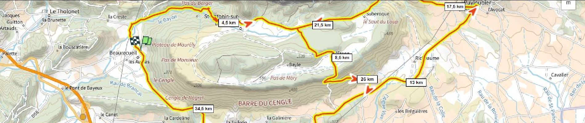
![](/images/other/stat-length.png)
le 8 du Cengle D+750m
ericberlin
Usuario
![Longitud](/images/other/stat-length.png)
![Altitud máxima](https://static1.geolcdn.com/siteimages/upload/files/1508320355ic_sort_altitude_max_24dp.png)
![Desnivel positivo](https://static1.geolcdn.com/siteimages/upload/files/1508320355ic_sort_den_pos_24dp.png)
![Km-Effort](/images/other/stat-length.png)
![Altitud mínima](https://static1.geolcdn.com/siteimages/upload/files/1508320355ic_sort_altitude_min_24dp.png)
![Desnivel negativo](https://static1.geolcdn.com/siteimages/upload/files/1508320355ic_sort_den_neg_24dp.png)
![Boucle](https://static1.geolcdn.com/siteimages/upload/files/16400158638029165_repeat_loop_refresh_sync_direction_icon.png)
![Bici de carretera](https://static1.geolcdn.com/sitytour/trail-icons/201.png)
2h51
Dificultad : Muy difícil
![Escanee este código QR para abrir la excursión en la aplicación SityTrail](https://capi.geolives.com/qq0zvz2zws4bq2lad0pu/sitytour/trails/3075102/qr.png?size=200)
Aplicación GPS de excursión GRATIS
A propósito
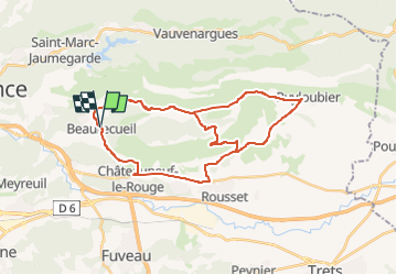
Ruta Bici de carretera de 37 km a descubrir en Provenza-Alpes-Costa Azul, Bocas del Ródano, Beaurecueil. Esta ruta ha sido propuesta por ericberlin.
Descripción
On passe 2 fois le pas de Magnan parce qu'on ne se lasse pas de son panorama :)
Le mieux est de partir des Bannettes pour se chauffer les cuisses.
Piste cyclable sur la D7 entre Rousset (Les Bannettes) et Châteauneuf depuis 2021.
Localización
Comentarios
Excursiones cerca
![Excursión Senderismo Saint-Antonin-sur-Bayon - Ste Victoire - Le Garagaï - Photo](https://media.geolcdn.com/t/375/260/2ae6dfca-d10e-4ad0-a555-d7a2df31e780.jpg&format=jpg&maxdim=2)
![Senderismo Senderismo](https://static1.geolcdn.com/sitytour/trail-icons/101.png)
Senderismo
![](/images/other/stat-length.png)
![](https://static1.geolcdn.com/siteimages/upload/files/16400158638029165_repeat_loop_refresh_sync_direction_icon.png)
![Excursión Senderismo Aix-en-Provence - Circuit des lacs Zola et Bimont - Aix-en-Provence - Photo](https://media.geolcdn.com/t/375/260/ext.jpg?maxdim=2&url=https%3A%2F%2Fservices.sitytrail.com%2FGeolivesWS%2FDownloadMedia.ashx%3FTrailID%3D173043%26Media%3D14560_6.jpg)
![Senderismo Senderismo](https://static1.geolcdn.com/sitytour/trail-icons/101.png)
Senderismo
![](/images/other/stat-length.png)
![](https://static1.geolcdn.com/siteimages/upload/files/16400158638029165_repeat_loop_refresh_sync_direction_icon.png)
![Excursión Senderismo Saint-Marc-Jaumegarde - Barrages Zola-Bimont - Photo](https://media.geolcdn.com/t/375/260/4dc70101-718b-4211-92e1-c206f426269b.jpg&format=jpg&maxdim=2)
![Senderismo Senderismo](https://static1.geolcdn.com/sitytour/trail-icons/101.png)
Senderismo
![](/images/other/stat-length.png)
![](https://static1.geolcdn.com/siteimages/upload/files/16400158638029165_repeat_loop_refresh_sync_direction_icon.png)
![Excursión Senderismo Vauvenargues - Le Signal, Montagne Sainte-Victoire - Photo](https://media.geolcdn.com/t/375/260/ext.jpg?maxdim=2&url=https%3A%2F%2Fservices.sitytrail.com%2FGeolivesWS%2FDownloadMedia.ashx%3FTrailID%3D106346%26Media%3D10812_1.jpg)
![Senderismo Senderismo](https://static1.geolcdn.com/sitytour/trail-icons/101.png)
Senderismo
![](/images/other/stat-length.png)
![](https://static1.geolcdn.com/siteimages/upload/files/16400158638029165_repeat_loop_refresh_sync_direction_icon.png)
![Excursión Senderismo Saint-Marc-Jaumegarde - La Croix de Provence depuis le barrage de Bimont - Photo](https://media.geolcdn.com/t/375/260/ext.jpg?maxdim=2&url=https%3A%2F%2Fservices.sitytrail.com%2FGeolivesWS%2FDownloadMedia.ashx%3FTrailID%3D103825%26Media%3D6599_1.jpg)
![Senderismo Senderismo](https://static1.geolcdn.com/sitytour/trail-icons/101.png)
Senderismo
![](/images/other/stat-length.png)
![](https://static1.geolcdn.com/siteimages/upload/files/16400158638029165_repeat_loop_refresh_sync_direction_icon.png)
![Excursión Senderismo Saint-Marc-Jaumegarde - Randonnée des crêtes au départ du barrage de Bimont - Photo](https://media.geolcdn.com/t/375/260/f5fd4b67-08c6-4cdc-bfa9-7a770b929a06.jpg&format=jpg&maxdim=2)
![Senderismo Senderismo](https://static1.geolcdn.com/sitytour/trail-icons/101.png)
Senderismo
![](/images/other/stat-length.png)
![](https://static1.geolcdn.com/siteimages/upload/files/16400158638029165_repeat_loop_refresh_sync_direction_icon.png)
![Excursión Senderismo Aix-en-Provence - Randonnée des barrages Zola et Bimont - Photo](https://media.geolcdn.com/t/375/260/6cce4a57-5683-4820-95a9-df589c3aadcb.jpg&format=jpg&maxdim=2)
![Senderismo Senderismo](https://static1.geolcdn.com/sitytour/trail-icons/101.png)
Senderismo
![](/images/other/stat-length.png)
![](https://static1.geolcdn.com/siteimages/upload/files/16400158638029165_repeat_loop_refresh_sync_direction_icon.png)
![Excursión Senderismo Le Tholonet - Le Tholonet -La Croix de Provence Par les Lacs Zola et Bimont - Photo](https://media.geolcdn.com/t/375/260/c97ea994-b71a-4c79-84a6-ec8711624c80.jpg&format=jpg&maxdim=2)
![Senderismo Senderismo](https://static1.geolcdn.com/sitytour/trail-icons/101.png)
Senderismo
![](/images/other/stat-length.png)
![](https://static1.geolcdn.com/siteimages/upload/files/16400158638029165_repeat_loop_refresh_sync_direction_icon.png)
![Excursión Senderismo Saint-Antonin-sur-Bayon - 2023-02-10 Sainte Victoire Bau des Vespres - Photo](https://media.geolcdn.com/t/375/260/36cf2b9f-8e2f-45fe-90b0-1fa100759227.jpg&format=jpg&maxdim=2)
![Senderismo Senderismo](https://static1.geolcdn.com/sitytour/trail-icons/101.png)
Senderismo
![](/images/other/stat-length.png)
![](https://static1.geolcdn.com/siteimages/upload/files/16400158638029165_repeat_loop_refresh_sync_direction_icon.png)