![](/images/other/stat-length.png)
![Excursión Senderismo Saint-Clément-de-la-Place - 2018-09-27 - Photo](https://media.geolcdn.com/t/1900/400/ext.pjpeg?maxdim=2&url=https%3A%2F%2Fstatic1.geolcdn.com%2Fsiteimages%2Fupload%2Ffiles%2F1553511878bg_sport_marche.png)
2018-09-27
Association ARCA49
Autour de la randonnée
![Longitud](/images/other/stat-length.png)
Longitud
12,3 km
![Altitud máxima](https://static1.geolcdn.com/siteimages/upload/files/1508320355ic_sort_altitude_max_24dp.png)
Altitud máxima
70 m
![Desnivel positivo](https://static1.geolcdn.com/siteimages/upload/files/1508320355ic_sort_den_pos_24dp.png)
Desnivel positivo
83 m
![Km-Effort](/images/other/stat-length.png)
Km-Effort
13,4 km
![Altitud mínima](https://static1.geolcdn.com/siteimages/upload/files/1508320355ic_sort_altitude_min_24dp.png)
Altitud mínima
46 m
![Desnivel negativo](https://static1.geolcdn.com/siteimages/upload/files/1508320355ic_sort_den_neg_24dp.png)
Desnivel negativo
86 m
![Boucle](https://static1.geolcdn.com/siteimages/upload/files/16400158638029165_repeat_loop_refresh_sync_direction_icon.png)
Boucle
Sí
Fecha de creación :
2021-11-19 12:45:59.233
Última modificación :
2022-05-04 08:12:26.647
![Senderismo](https://static1.geolcdn.com/sitytour/trail-icons/101.png)
3h02
Dificultad : Difícil
![Escanee este código QR para abrir la excursión en la aplicación SityTrail](https://capi.geolives.com/qq0zvz2zws4bq2lad0pu/sitytour/trails/3065093/qr.png?size=200)
Aplicación GPS de excursión GRATIS
A propósito
Ruta Senderismo de 12,3 km a descubrir en Países del Loira, Maine-y-Loira, Saint-Clément-de-la-Place. Esta ruta ha sido propuesta por Association ARCA49.
Descripción
Saint Clément de la Place
Localización
País:
France
Región :
Países del Loira
Departamento/provincia :
Maine-y-Loira
Municipio :
Saint-Clément-de-la-Place
Localidad:
Unknown
Salida:(Dec)
Salida:(UTM)
669822 ; 5266007 (30T) N.
Comentarios
Excursiones cerca
![Excursión Senderismo Saint-Clément-de-la-Place - SityTrail - 3065093 - bocage-et-haras - Photo](https://media.geolcdn.com/t/375/260/ext.jpg?maxdim=2&url=https%3A%2F%2Fstatic1.geolcdn.com%2Fsiteimages%2Fupload%2Ffiles%2F1553511878bg_sport_marche.png)
![Senderismo Senderismo](https://static1.geolcdn.com/sitytour/trail-icons/101.png)
SityTrail - 3065093 - bocage-et-haras
Senderismo
Difícil
Saint-Clément-de-la-Place,
Países del Loira,
Maine-y-Loira,
France
![](/images/other/stat-length.png)
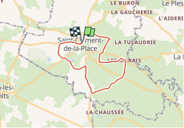
12,3 km | 13,4 km-effort
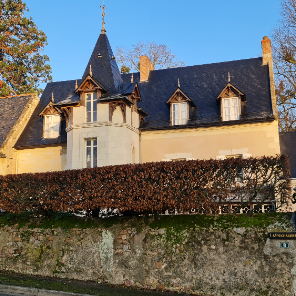
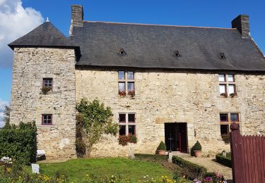
3h 2min
![](https://static1.geolcdn.com/siteimages/upload/files/16400158638029165_repeat_loop_refresh_sync_direction_icon.png)
Sí
![Excursión Paseo ecuestre Erdre-en-Anjou - etape 5 La Poueze le lion d'Angers - Photo](https://media.geolcdn.com/t/375/260/ext.jpg?maxdim=2&url=https%3A%2F%2Fstatic1.geolcdn.com%2Fsiteimages%2Fupload%2Ffiles%2F1524743154cheval.jpg)
![Paseo ecuestre Paseo ecuestre](https://static1.geolcdn.com/sitytour/trail-icons/301.png)
etape 5 La Poueze le lion d'Angers
Paseo ecuestre
Difícil
Erdre-en-Anjou,
Países del Loira,
Maine-y-Loira,
France
![](/images/other/stat-length.png)
29 km | 33 km-effort
4h 28min
![](https://static1.geolcdn.com/siteimages/upload/files/16400158638029165_repeat_loop_refresh_sync_direction_icon.png)
No
![Excursión Senderismo Bécon-les-Granits - Becon les granits - Photo](https://media.geolcdn.com/t/375/260/df1aad04-c724-422e-ab80-f2c7d51ba721.jpg&format=jpg&maxdim=2)
![Senderismo Senderismo](https://static1.geolcdn.com/sitytour/trail-icons/101.png)
Becon les granits
Senderismo
Muy fácil
Bécon-les-Granits,
Países del Loira,
Maine-y-Loira,
France
![](/images/other/stat-length.png)
11 km | 12,1 km-effort
2h 59min
![](https://static1.geolcdn.com/siteimages/upload/files/16400158638029165_repeat_loop_refresh_sync_direction_icon.png)
Sí
![Excursión Senderismo Bécon-les-Granits - SityTrail - 3297337 - becon-les-granits - Photo](https://media.geolcdn.com/t/375/260/ext.jpg?maxdim=2&url=https%3A%2F%2Fstatic1.geolcdn.com%2Fsiteimages%2Fupload%2Ffiles%2F1553511878bg_sport_marche.png)
![Senderismo Senderismo](https://static1.geolcdn.com/sitytour/trail-icons/101.png)
SityTrail - 3297337 - becon-les-granits
Senderismo
Difícil
(1)
Bécon-les-Granits,
Países del Loira,
Maine-y-Loira,
France
![](/images/other/stat-length.png)
13 km | 14,8 km-effort
3h 21min
![](https://static1.geolcdn.com/siteimages/upload/files/16400158638029165_repeat_loop_refresh_sync_direction_icon.png)
Sí
![Excursión Senderismo Bécon-les-Granits - HCLM - Becon - Photo](https://media.geolcdn.com/t/375/260/ext.jpg?maxdim=2&url=https%3A%2F%2Fstatic1.geolcdn.com%2Fsiteimages%2Fupload%2Ffiles%2F1553511878bg_sport_marche.png)
![Senderismo Senderismo](https://static1.geolcdn.com/sitytour/trail-icons/101.png)
HCLM - Becon
Senderismo
Fácil
Bécon-les-Granits,
Países del Loira,
Maine-y-Loira,
France
![](/images/other/stat-length.png)
5,1 km | 5,4 km-effort
1h 37min
![](https://static1.geolcdn.com/siteimages/upload/files/16400158638029165_repeat_loop_refresh_sync_direction_icon.png)
No
![Excursión Marcha nórdica Saint-Lambert-la-Potherie - St Lambert -St Leger - Photo](https://media.geolcdn.com/t/375/260/ext.jpg?maxdim=2&url=https%3A%2F%2Fstatic1.geolcdn.com%2Fsiteimages%2Fupload%2Ffiles%2F1545311037marcheuse_200dpi.jpg)
![Marcha nórdica Marcha nórdica](https://static1.geolcdn.com/sitytour/trail-icons/102.png)
St Lambert -St Leger
Marcha nórdica
Fácil
Saint-Lambert-la-Potherie,
Países del Loira,
Maine-y-Loira,
France
![](/images/other/stat-length.png)
16,7 km | 18,3 km-effort
2h 53min
![](https://static1.geolcdn.com/siteimages/upload/files/16400158638029165_repeat_loop_refresh_sync_direction_icon.png)
Sí
![Excursión Senderismo Bécon-les-Granits - randogps49-214 - Photo](https://media.geolcdn.com/t/375/260/ext.jpg?maxdim=2&url=https%3A%2F%2Fstatic1.geolcdn.com%2Fsiteimages%2Fupload%2Ffiles%2F1553511878bg_sport_marche.png)
![Senderismo Senderismo](https://static1.geolcdn.com/sitytour/trail-icons/101.png)
randogps49-214
Senderismo
Difícil
(1)
Bécon-les-Granits,
Países del Loira,
Maine-y-Loira,
France
![](/images/other/stat-length.png)
13 km | 14,8 km-effort
2h 59min
![](https://static1.geolcdn.com/siteimages/upload/files/16400158638029165_repeat_loop_refresh_sync_direction_icon.png)
Sí
![Excursión Senderismo Saint-Lambert-la-Potherie - gpx-trace - Photo](https://media.geolcdn.com/t/375/260/ext.jpg?maxdim=2&url=https%3A%2F%2Fstatic1.geolcdn.com%2Fsiteimages%2Fupload%2Ffiles%2F1553511878bg_sport_marche.png)
![Senderismo Senderismo](https://static1.geolcdn.com/sitytour/trail-icons/101.png)
gpx-trace
Senderismo
Difícil
(1)
Saint-Lambert-la-Potherie,
Países del Loira,
Maine-y-Loira,
France
![](/images/other/stat-length.png)
14,9 km | 16 km-effort
3h 37min
![](https://static1.geolcdn.com/siteimages/upload/files/16400158638029165_repeat_loop_refresh_sync_direction_icon.png)
Sí
![Excursión Senderismo Saint-Lambert-la-Potherie - Boucle du bourg - St Lambert La Potherie - Photo](https://media.geolcdn.com/t/375/260/ext.jpg?maxdim=2&url=https%3A%2F%2Fstatic1.geolcdn.com%2Fsiteimages%2Fupload%2Ffiles%2F1553511878bg_sport_marche.png)
![Senderismo Senderismo](https://static1.geolcdn.com/sitytour/trail-icons/101.png)
Boucle du bourg - St Lambert La Potherie
Senderismo
Muy fácil
Saint-Lambert-la-Potherie,
Países del Loira,
Maine-y-Loira,
France
![](/images/other/stat-length.png)
5,9 km | 6,5 km-effort
1h 28min
![](https://static1.geolcdn.com/siteimages/upload/files/16400158638029165_repeat_loop_refresh_sync_direction_icon.png)
Sí