![](/images/other/stat-length.png)
![Excursión Ruta Eyguières - Crêtes de sainte Cécile - Photo](https://media.geolcdn.com/t/1900/400/ext.pjpeg?maxdim=2&url=https%3A%2F%2Fstatic1.geolcdn.com%2Fsiteimages%2Fupload%2Ffiles%2F1524743154running.jpg)
Crêtes de sainte Cécile
tophe13430
Usuario
![Longitud](/images/other/stat-length.png)
Longitud
7,6 km
![Altitud máxima](https://static1.geolcdn.com/siteimages/upload/files/1508320355ic_sort_altitude_max_24dp.png)
Altitud máxima
283 m
![Desnivel positivo](https://static1.geolcdn.com/siteimages/upload/files/1508320355ic_sort_den_pos_24dp.png)
Desnivel positivo
201 m
![Km-Effort](/images/other/stat-length.png)
Km-Effort
10,3 km
![Altitud mínima](https://static1.geolcdn.com/siteimages/upload/files/1508320355ic_sort_altitude_min_24dp.png)
Altitud mínima
102 m
![Desnivel negativo](https://static1.geolcdn.com/siteimages/upload/files/1508320355ic_sort_den_neg_24dp.png)
Desnivel negativo
201 m
![Boucle](https://static1.geolcdn.com/siteimages/upload/files/16400158638029165_repeat_loop_refresh_sync_direction_icon.png)
Boucle
Sí
Fecha de creación :
2022-01-15 13:21:51.0
Última modificación :
2022-01-15 15:38:14.3
![Ruta](https://static1.geolcdn.com/sitytour/trail-icons/104.png)
2h15
Dificultad : Difícil
![Escanee este código QR para abrir la excursión en la aplicación SityTrail](https://capi.geolives.com/qq0zvz2zws4bq2lad0pu/sitytour/trails/3052347/qr.png?size=200)
Aplicación GPS de excursión GRATIS
A propósito
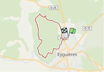
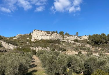
Ruta Ruta de 7,6 km a descubrir en Provenza-Alpes-Costa Azul, Bocas del Ródano, Eyguières. Esta ruta ha sido propuesta por tophe13430.
Descripción
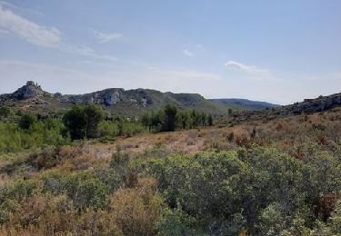
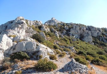
Itinéraire sportif sur les crêtes oscillant entre d’un côté Eyguieres et le vallon des Glauges.
Si vous avez de la chance vous croiserez les chèvres semi sauvages sur la partie sud de l’itinéraire.
Localización
País:
France
Región :
Provenza-Alpes-Costa Azul
Departamento/provincia :
Bocas del Ródano
Municipio :
Eyguières
Localidad:
Unknown
Salida:(Dec)
Salida:(UTM)
663606 ; 4840832 (31T) N.
Comentarios
Excursiones cerca
![Excursión Senderismo Eyguières - Tour du Mont Menu - MR - Photo](https://media.geolcdn.com/t/375/260/30e75c1f-6989-4149-84bb-d132222e741d.jpg&format=jpg&maxdim=2)
![Senderismo Senderismo](https://static1.geolcdn.com/sitytour/trail-icons/101.png)
Tour du Mont Menu - MR
Senderismo
Fácil
(1)
Eyguières,
Provenza-Alpes-Costa Azul,
Bocas del Ródano,
France
![](/images/other/stat-length.png)
8,8 km | 11,4 km-effort
2h 34min
![](https://static1.geolcdn.com/siteimages/upload/files/16400158638029165_repeat_loop_refresh_sync_direction_icon.png)
Sí
![Excursión Senderismo Lamanon - lamanon grottes calas - Photo](https://media.geolcdn.com/t/375/260/ext.jpg?maxdim=2&url=https%3A%2F%2Fservices.sitytrail.com%2FGeolivesWS%2FDownloadMedia.ashx%3FTrailID%3D135315%26Media%3D20120624103237.jpg)
![Senderismo Senderismo](https://static1.geolcdn.com/sitytour/trail-icons/101.png)
lamanon grottes calas
Senderismo
Muy fácil
(1)
Lamanon,
Provenza-Alpes-Costa Azul,
Bocas del Ródano,
France
![](/images/other/stat-length.png)
9,7 km | 13 km-effort
2h 38min
![](https://static1.geolcdn.com/siteimages/upload/files/16400158638029165_repeat_loop_refresh_sync_direction_icon.png)
No
![Excursión Senderismo Lamanon - Les murs d'abeilles de Lamanon et les grottes de Calès - Photo](https://media.geolcdn.com/t/375/260/ext.jpg?maxdim=2&url=https%3A%2F%2Fstatic1.geolcdn.com%2Fsiteimages%2Fupload%2Ffiles%2F1553511878bg_sport_marche.png)
![Senderismo Senderismo](https://static1.geolcdn.com/sitytour/trail-icons/101.png)
Les murs d'abeilles de Lamanon et les grottes de Calès
Senderismo
Medio
(1)
Lamanon,
Provenza-Alpes-Costa Azul,
Bocas del Ródano,
France
![](/images/other/stat-length.png)
8,3 km | 12,1 km-effort
2h 45min
![](https://static1.geolcdn.com/siteimages/upload/files/16400158638029165_repeat_loop_refresh_sync_direction_icon.png)
Sí
![Excursión Senderismo Lamanon - PF-Lamanon - Le Mur aux Abeilles - Photo](https://media.geolcdn.com/t/375/260/3155d616-22ac-42d6-b419-c91496a74461.jpg&format=jpg&maxdim=2)
![Senderismo Senderismo](https://static1.geolcdn.com/sitytour/trail-icons/101.png)
PF-Lamanon - Le Mur aux Abeilles
Senderismo
Medio
Lamanon,
Provenza-Alpes-Costa Azul,
Bocas del Ródano,
France
![](/images/other/stat-length.png)
6,5 km | 9,1 km-effort
2h 23min
![](https://static1.geolcdn.com/siteimages/upload/files/16400158638029165_repeat_loop_refresh_sync_direction_icon.png)
Sí
![Excursión Senderismo Eyguières - La Tour des Opies - Photo](https://media.geolcdn.com/t/375/260/7698f35a-9dd4-47f9-80ac-1fcb11d76a89.jpg&format=jpg&maxdim=2)
![Senderismo Senderismo](https://static1.geolcdn.com/sitytour/trail-icons/101.png)
La Tour des Opies
Senderismo
Difícil
Eyguières,
Provenza-Alpes-Costa Azul,
Bocas del Ródano,
France
![](/images/other/stat-length.png)
11,6 km | 16,9 km-effort
3h 33min
![](https://static1.geolcdn.com/siteimages/upload/files/16400158638029165_repeat_loop_refresh_sync_direction_icon.png)
Sí
![Excursión Senderismo Eyguières - PF-Eyguières - Le Vallon des Glauges - Photo](https://media.geolcdn.com/t/375/260/ext.jpg?maxdim=2&url=https%3A%2F%2Fservices.sitytrail.com%2FGeolivesWS%2FDownloadMedia.ashx%3FTrailID%3D392613%26Media%3D20150305155346.jpg)
![Senderismo Senderismo](https://static1.geolcdn.com/sitytour/trail-icons/101.png)
PF-Eyguières - Le Vallon des Glauges
Senderismo
Muy fácil
Eyguières,
Provenza-Alpes-Costa Azul,
Bocas del Ródano,
France
![](/images/other/stat-length.png)
8,4 km | 9,6 km-effort
2h 9min
![](https://static1.geolcdn.com/siteimages/upload/files/16400158638029165_repeat_loop_refresh_sync_direction_icon.png)
Sí
![Excursión Senderismo Lamanon - Lamanon Cales Facile - Photo](https://media.geolcdn.com/t/375/260/ext.jpg?maxdim=2&url=https%3A%2F%2Fstatic1.geolcdn.com%2Fsiteimages%2Fupload%2Ffiles%2F1553511878bg_sport_marche.png)
![Senderismo Senderismo](https://static1.geolcdn.com/sitytour/trail-icons/101.png)
Lamanon Cales Facile
Senderismo
Fácil
(1)
Lamanon,
Provenza-Alpes-Costa Azul,
Bocas del Ródano,
France
![](/images/other/stat-length.png)
6,2 km | 8,9 km-effort
1h 30min
![](https://static1.geolcdn.com/siteimages/upload/files/16400158638029165_repeat_loop_refresh_sync_direction_icon.png)
Sí
![Excursión Senderismo Eyguières - PF-Eyguières - Le Tour du Mont Menu - MR - Photo](https://media.geolcdn.com/t/375/260/98e14d34-5d88-4cd5-8bf9-2c07b9ccf996.jpg&format=jpg&maxdim=2)
![Senderismo Senderismo](https://static1.geolcdn.com/sitytour/trail-icons/101.png)
PF-Eyguières - Le Tour du Mont Menu - MR
Senderismo
Medio
Eyguières,
Provenza-Alpes-Costa Azul,
Bocas del Ródano,
France
![](/images/other/stat-length.png)
8,9 km | 11,4 km-effort
3h 5min
![](https://static1.geolcdn.com/siteimages/upload/files/16400158638029165_repeat_loop_refresh_sync_direction_icon.png)
Sí
![Excursión Senderismo Eyguières - 2017-05-15 17:18:59 - Photo](https://media.geolcdn.com/t/375/260/14c2f837-660f-4940-bba7-8dafeeb13df3.jpg&format=jpg&maxdim=2)
![Senderismo Senderismo](https://static1.geolcdn.com/sitytour/trail-icons/101.png)
2017-05-15 17:18:59
Senderismo
Fácil
Eyguières,
Provenza-Alpes-Costa Azul,
Bocas del Ródano,
France
![](/images/other/stat-length.png)
9,6 km | 11,1 km-effort
2h 30min
![](https://static1.geolcdn.com/siteimages/upload/files/16400158638029165_repeat_loop_refresh_sync_direction_icon.png)
Sí