![](/images/other/stat-length.png)
![Excursión Senderismo Varengeville-sur-Mer - SityTrail - 3040036 - varengeville-2022-01-02 - Photo](https://media.geolcdn.com/t/1900/400/ext.pjpeg?maxdim=2&url=https%3A%2F%2Fstatic1.geolcdn.com%2Fsiteimages%2Fupload%2Ffiles%2F1553511878bg_sport_marche.png)
SityTrail - 3040036 - varengeville-2022-01-02
phiber76
Usuario
![Longitud](/images/other/stat-length.png)
Longitud
20 km
![Altitud máxima](https://static1.geolcdn.com/siteimages/upload/files/1508320355ic_sort_altitude_max_24dp.png)
Altitud máxima
101 m
![Desnivel positivo](https://static1.geolcdn.com/siteimages/upload/files/1508320355ic_sort_den_pos_24dp.png)
Desnivel positivo
409 m
![Km-Effort](/images/other/stat-length.png)
Km-Effort
26 km
![Altitud mínima](https://static1.geolcdn.com/siteimages/upload/files/1508320355ic_sort_altitude_min_24dp.png)
Altitud mínima
0 m
![Desnivel negativo](https://static1.geolcdn.com/siteimages/upload/files/1508320355ic_sort_den_neg_24dp.png)
Desnivel negativo
408 m
![Boucle](https://static1.geolcdn.com/siteimages/upload/files/16400158638029165_repeat_loop_refresh_sync_direction_icon.png)
Boucle
Sí
Fecha de creación :
2022-01-03 09:06:18.378
Última modificación :
2022-01-03 09:07:52.061
![Senderismo](https://static1.geolcdn.com/sitytour/trail-icons/101.png)
--
Dificultad : Desconocido
![Escanee este código QR para abrir la excursión en la aplicación SityTrail](https://capi.geolives.com/qq0zvz2zws4bq2lad0pu/sitytour/trails/3040239/qr.png?size=200)
Aplicación GPS de excursión GRATIS
A propósito
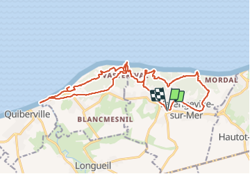
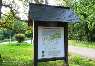
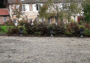
Ruta Senderismo de 20 km a descubrir en Normandía, Sena-Marítimo, Varengeville-sur-Mer. Esta ruta ha sido propuesta por phiber76.
Descripción
déjà fait en 2017 dans le sens anthioraire
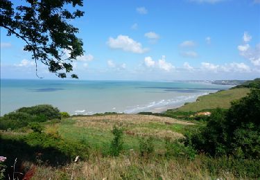
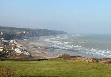
Les plus: maisons à Varengeville, les valleuses, les bois, les points de vue.
Randonnée physique (falaises)
Localización
País:
France
Región :
Normandía
Departamento/provincia :
Sena-Marítimo
Municipio :
Varengeville-sur-Mer
Localidad:
Unknown
Salida:(Dec)
Salida:(UTM)
355868 ; 5529909 (31U) N.
Comentarios
Excursiones cerca
![Excursión Senderismo Varengeville-sur-Mer - Balade à Varengeville sur Mer - Photo](https://media.geolcdn.com/t/375/260/ext.jpg?maxdim=2&url=https%3A%2F%2Fservices.sitytrail.com%2FGeolivesWS%2FDownloadMedia.ashx%3FTrailID%3D172689%26Media%3D14067_5.jpg)
![Senderismo Senderismo](https://static1.geolcdn.com/sitytour/trail-icons/101.png)
Balade à Varengeville sur Mer
Senderismo
Medio
(1)
Varengeville-sur-Mer,
Normandía,
Sena-Marítimo,
France
![](/images/other/stat-length.png)
10,9 km | 14 km-effort
3h 0min
![](https://static1.geolcdn.com/siteimages/upload/files/16400158638029165_repeat_loop_refresh_sync_direction_icon.png)
Sí
![Excursión Senderismo Sainte-Marguerite-sur-Mer - 076-09- Dieppes Matin 13km-793264 - Photo](https://media.geolcdn.com/t/375/260/3317efcd-fa2f-4145-b995-2be0c6694e9d.jpg&format=jpg&maxdim=2)
![Senderismo Senderismo](https://static1.geolcdn.com/sitytour/trail-icons/101.png)
076-09- Dieppes Matin 13km-793264
Senderismo
Medio
(1)
Sainte-Marguerite-sur-Mer,
Normandía,
Sena-Marítimo,
France
![](/images/other/stat-length.png)
11,9 km | 15,5 km-effort
4h 47min
![](https://static1.geolcdn.com/siteimages/upload/files/16400158638029165_repeat_loop_refresh_sync_direction_icon.png)
No
![Excursión Senderismo Varengeville-sur-Mer - Pourville jusqu'aux Terrasses de Vasterival - Photo](https://media.geolcdn.com/t/375/260/ext.jpg?maxdim=2&url=https%3A%2F%2Fstatic1.geolcdn.com%2Fsiteimages%2Fupload%2Ffiles%2F1553511878bg_sport_marche.png)
![Senderismo Senderismo](https://static1.geolcdn.com/sitytour/trail-icons/101.png)
Pourville jusqu'aux Terrasses de Vasterival
Senderismo
Fácil
(1)
Varengeville-sur-Mer,
Normandía,
Sena-Marítimo,
France
![](/images/other/stat-length.png)
11,7 km | 15,1 km-effort
3h 53min
![](https://static1.geolcdn.com/siteimages/upload/files/16400158638029165_repeat_loop_refresh_sync_direction_icon.png)
Sí
![Excursión Senderismo Varengeville-sur-Mer - De la plage de Vastérival au phare d'Ailly - Photo](https://media.geolcdn.com/t/375/260/ext.jpg?maxdim=2&url=https%3A%2F%2Fservices.sitytrail.com%2FGeolivesWS%2FDownloadMedia.ashx%3FTrailID%3D156645%26Media%3Dd5206471-921c-475f-bbc1-fc45d140039a.jpg)
![Senderismo Senderismo](https://static1.geolcdn.com/sitytour/trail-icons/101.png)
De la plage de Vastérival au phare d'Ailly
Senderismo
Muy fácil
Varengeville-sur-Mer,
Normandía,
Sena-Marítimo,
France
![](/images/other/stat-length.png)
5,3 km | 6,5 km-effort
1h 20min
![](https://static1.geolcdn.com/siteimages/upload/files/16400158638029165_repeat_loop_refresh_sync_direction_icon.png)
Sí
![Excursión Senderismo Varengeville-sur-Mer - Balade à Varengeville sur Mer - Photo](https://media.geolcdn.com/t/375/260/ext.jpg?maxdim=2&url=https%3A%2F%2Fservices.sitytrail.com%2FGeolivesWS%2FDownloadMedia.ashx%3FTrailID%3D156466%26Media%3D73525a37-9728-4871-bae2-ca6386d374b7.jpg)
![Senderismo Senderismo](https://static1.geolcdn.com/sitytour/trail-icons/101.png)
Balade à Varengeville sur Mer
Senderismo
Fácil
Varengeville-sur-Mer,
Normandía,
Sena-Marítimo,
France
![](/images/other/stat-length.png)
10,9 km | 14 km-effort
2h 50min
![](https://static1.geolcdn.com/siteimages/upload/files/16400158638029165_repeat_loop_refresh_sync_direction_icon.png)
Sí
![Excursión Senderismo Longueil - longueil - Photo](https://media.geolcdn.com/t/375/260/ext.jpg?maxdim=2&url=https%3A%2F%2Fstatic1.geolcdn.com%2Fsiteimages%2Fupload%2Ffiles%2F1553511878bg_sport_marche.png)
![Senderismo Senderismo](https://static1.geolcdn.com/sitytour/trail-icons/101.png)
longueil
Senderismo
Difícil
(1)
Longueil,
Normandía,
Sena-Marítimo,
France
![](/images/other/stat-length.png)
11,6 km | 14,1 km-effort
3h 12min
![](https://static1.geolcdn.com/siteimages/upload/files/16400158638029165_repeat_loop_refresh_sync_direction_icon.png)
Sí
![Excursión Senderismo Hautot-sur-Mer - Autour de Varengeville-sur-Mer - Photo](https://media.geolcdn.com/t/375/260/60d902af-7cf1-469a-9cec-da74be4158a3.jpeg&format=jpg&maxdim=2)
![Senderismo Senderismo](https://static1.geolcdn.com/sitytour/trail-icons/101.png)
Autour de Varengeville-sur-Mer
Senderismo
Medio
Hautot-sur-Mer,
Normandía,
Sena-Marítimo,
France
![](/images/other/stat-length.png)
20 km | 26 km-effort
4h 19min
![](https://static1.geolcdn.com/siteimages/upload/files/16400158638029165_repeat_loop_refresh_sync_direction_icon.png)
Sí
![Excursión Senderismo Hautot-sur-Mer - Petit Appeville vers Pourville sur mer - Photo](https://media.geolcdn.com/t/375/260/f27eecc9-b419-4f96-979b-ca5c51e90ae0.jpg&format=jpg&maxdim=2)
![Senderismo Senderismo](https://static1.geolcdn.com/sitytour/trail-icons/101.png)
Petit Appeville vers Pourville sur mer
Senderismo
Medio
Hautot-sur-Mer,
Normandía,
Sena-Marítimo,
France
![](/images/other/stat-length.png)
11,5 km | 14,9 km-effort
3h 12min
![](https://static1.geolcdn.com/siteimages/upload/files/16400158638029165_repeat_loop_refresh_sync_direction_icon.png)
Sí
![Excursión sport Varengeville-sur-Mer - 201804124-Varengeville_sur_Mer - Photo](https://media.geolcdn.com/t/375/260/ext.jpg?maxdim=2&url=https%3A%2F%2Fsecurestorage.geolives.com%2Fsitytour%2Ftrail-bg%2Fdefault.jpg)
201804124-Varengeville_sur_Mer
sport
Muy fácil
(1)
Varengeville-sur-Mer,
Normandía,
Sena-Marítimo,
France
![](/images/other/stat-length.png)
15,4 km | 19,5 km-effort
Desconocido
![](https://static1.geolcdn.com/siteimages/upload/files/16400158638029165_repeat_loop_refresh_sync_direction_icon.png)
Sí