![](/images/other/stat-length.png)
![Excursión Senderismo Rayol-Canadel-sur-Mer - Les Hauts de Pramousquier - Photo](https://media.geolcdn.com/t/1900/400/ext.pjpeg?maxdim=2&url=https%3A%2F%2Fstatic1.geolcdn.com%2Fsiteimages%2Fupload%2Ffiles%2F1553511878bg_sport_marche.png)
Les Hauts de Pramousquier
PhL83
Usuario
![Longitud](/images/other/stat-length.png)
Longitud
12,9 km
![Altitud máxima](https://static1.geolcdn.com/siteimages/upload/files/1508320355ic_sort_altitude_max_24dp.png)
Altitud máxima
424 m
![Desnivel positivo](https://static1.geolcdn.com/siteimages/upload/files/1508320355ic_sort_den_pos_24dp.png)
Desnivel positivo
502 m
![Km-Effort](/images/other/stat-length.png)
Km-Effort
19,5 km
![Altitud mínima](https://static1.geolcdn.com/siteimages/upload/files/1508320355ic_sort_altitude_min_24dp.png)
Altitud mínima
12 m
![Desnivel negativo](https://static1.geolcdn.com/siteimages/upload/files/1508320355ic_sort_den_neg_24dp.png)
Desnivel negativo
503 m
![Boucle](https://static1.geolcdn.com/siteimages/upload/files/16400158638029165_repeat_loop_refresh_sync_direction_icon.png)
Boucle
Sí
Fecha de creación :
2021-12-02 08:17:45.0
Última modificación :
2021-12-02 13:40:05.095
![Senderismo](https://static1.geolcdn.com/sitytour/trail-icons/101.png)
5h21
Dificultad : Medio
![Escanee este código QR para abrir la excursión en la aplicación SityTrail](https://capi.geolives.com/qq0zvz2zws4bq2lad0pu/sitytour/trails/3017463/qr.png?size=200)
Aplicación GPS de excursión GRATIS
A propósito
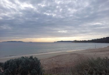
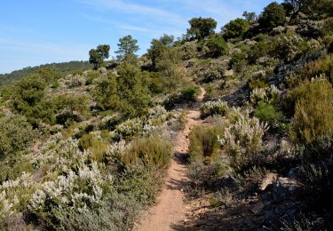
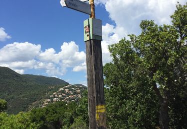
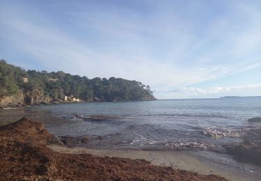
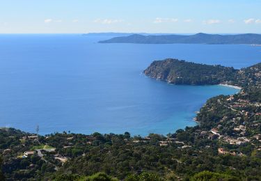
Ruta Senderismo de 12,9 km a descubrir en Provenza-Alpes-Costa Azul, Var, Rayol-Canadel-sur-Mer. Esta ruta ha sido propuesta por PhL83.
Descripción
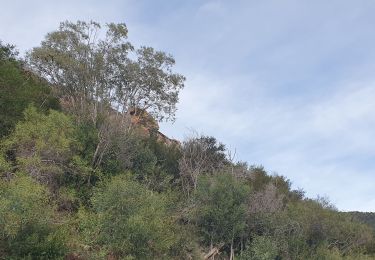
Superbe randonnée au- dessus du Rayol Canadel avec des vues magnifiques sur lès Îles
Localización
País:
France
Región :
Provenza-Alpes-Costa Azul
Departamento/provincia :
Var
Municipio :
Rayol-Canadel-sur-Mer
Localidad:
Unknown
Salida:(Dec)
Salida:(UTM)
293626 ; 4781512 (32T) N.
Comentarios
Excursiones cerca
![Excursión Senderismo Le Lavandou - Balcons de Pramousquier 22.1.23 - Photo](https://media.geolcdn.com/t/375/260/b49f05a7-2e02-450b-a614-7cc169048d9c.jpg&format=jpg&maxdim=2)
![Senderismo Senderismo](https://static1.geolcdn.com/sitytour/trail-icons/101.png)
Balcons de Pramousquier 22.1.23
Senderismo
Medio
Le Lavandou,
Provenza-Alpes-Costa Azul,
Var,
France
![](/images/other/stat-length.png)
12,3 km | 19,2 km-effort
4h 0min
![](https://static1.geolcdn.com/siteimages/upload/files/16400158638029165_repeat_loop_refresh_sync_direction_icon.png)
Sí
![Excursión Senderismo Rayol-Canadel-sur-Mer - Wikiloc - Le rayon canadel - Opidum de monjean - Photo](https://media.geolcdn.com/t/375/260/4e43ac4c-7667-474b-8d0a-9263d51cfdde.jpg&format=jpg&maxdim=2)
![Senderismo Senderismo](https://static1.geolcdn.com/sitytour/trail-icons/101.png)
Wikiloc - Le rayon canadel - Opidum de monjean
Senderismo
Difícil
Rayol-Canadel-sur-Mer,
Provenza-Alpes-Costa Azul,
Var,
France
![](/images/other/stat-length.png)
14,8 km | 24 km-effort
6h 0min
![](https://static1.geolcdn.com/siteimages/upload/files/16400158638029165_repeat_loop_refresh_sync_direction_icon.png)
Sí
![Excursión Senderismo Le Lavandou - cavaliere - Photo](https://media.geolcdn.com/t/375/260/ext.jpg?maxdim=2&url=https%3A%2F%2Fstatic1.geolcdn.com%2Fsiteimages%2Fupload%2Ffiles%2F1553511878bg_sport_marche.png)
![Senderismo Senderismo](https://static1.geolcdn.com/sitytour/trail-icons/101.png)
cavaliere
Senderismo
Medio
(1)
Le Lavandou,
Provenza-Alpes-Costa Azul,
Var,
France
![](/images/other/stat-length.png)
17,8 km | 28 km-effort
6h 59min
![](https://static1.geolcdn.com/siteimages/upload/files/16400158638029165_repeat_loop_refresh_sync_direction_icon.png)
Sí
![Excursión Senderismo Rayol-Canadel-sur-Mer - 20190222 rayol canadel - Photo](https://media.geolcdn.com/t/375/260/ext.jpg?maxdim=2&url=https%3A%2F%2Fstatic1.geolcdn.com%2Fsiteimages%2Fupload%2Ffiles%2F1553511878bg_sport_marche.png)
![Senderismo Senderismo](https://static1.geolcdn.com/sitytour/trail-icons/101.png)
20190222 rayol canadel
Senderismo
Fácil
(1)
Rayol-Canadel-sur-Mer,
Provenza-Alpes-Costa Azul,
Var,
France
![](/images/other/stat-length.png)
8 km | 11,1 km-effort
2h 38min
![](https://static1.geolcdn.com/siteimages/upload/files/16400158638029165_repeat_loop_refresh_sync_direction_icon.png)
Sí
![Excursión Senderismo Cavalaire-sur-Mer - Cavalaire 2 - Photo](https://media.geolcdn.com/t/375/260/66220656-f369-437d-a3c4-6a7ae56dd908.jpg&format=jpg&maxdim=2)
![Senderismo Senderismo](https://static1.geolcdn.com/sitytour/trail-icons/101.png)
Cavalaire 2
Senderismo
Difícil
Cavalaire-sur-Mer,
Provenza-Alpes-Costa Azul,
Var,
France
![](/images/other/stat-length.png)
9,3 km | 13,6 km-effort
3h 5min
![](https://static1.geolcdn.com/siteimages/upload/files/16400158638029165_repeat_loop_refresh_sync_direction_icon.png)
Sí
![Excursión Bicicleta híbrida Rayol-Canadel-sur-Mer - Vélo le col du Canadel et Parc de Port Cros - Photo](https://media.geolcdn.com/t/375/260/f6923b94-ab5d-42bf-aac8-dcd63edeb7c2.jpg&format=jpg&maxdim=2)
![Bicicleta híbrida Bicicleta híbrida](https://static1.geolcdn.com/sitytour/trail-icons/203.png)
Vélo le col du Canadel et Parc de Port Cros
Bicicleta híbrida
Medio
Rayol-Canadel-sur-Mer,
Provenza-Alpes-Costa Azul,
Var,
France
![](/images/other/stat-length.png)
43 km | 53 km-effort
3h 28min
![](https://static1.geolcdn.com/siteimages/upload/files/16400158638029165_repeat_loop_refresh_sync_direction_icon.png)
Sí
![Excursión Senderismo Rayol-Canadel-sur-Mer - Rayol 21.1.23 - Photo](https://media.geolcdn.com/t/375/260/94d35f60-4441-4919-856b-aad9de111be5.jpg&format=jpg&maxdim=2)
![Senderismo Senderismo](https://static1.geolcdn.com/sitytour/trail-icons/101.png)
Rayol 21.1.23
Senderismo
Fácil
Rayol-Canadel-sur-Mer,
Provenza-Alpes-Costa Azul,
Var,
France
![](/images/other/stat-length.png)
8,5 km | 13,1 km-effort
2h 44min
![](https://static1.geolcdn.com/siteimages/upload/files/16400158638029165_repeat_loop_refresh_sync_direction_icon.png)
Sí
![Excursión Senderismo Le Lavandou - cavaliere 11 janvier 2023 par le temple d'hercule - Photo](https://media.geolcdn.com/t/375/260/9ae44104-e723-4fc2-9ac1-bbbebd3c175a.jpg&format=jpg&maxdim=2)
![Senderismo Senderismo](https://static1.geolcdn.com/sitytour/trail-icons/101.png)
cavaliere 11 janvier 2023 par le temple d'hercule
Senderismo
Medio
Le Lavandou,
Provenza-Alpes-Costa Azul,
Var,
France
![](/images/other/stat-length.png)
11,4 km | 18,6 km-effort
3h 39min
![](https://static1.geolcdn.com/siteimages/upload/files/16400158638029165_repeat_loop_refresh_sync_direction_icon.png)
Sí
![Senderismo Senderismo](https://static1.geolcdn.com/sitytour/trail-icons/101.png)
Plage du Bonporteau et du Rayol
Senderismo
Medio
(1)
Cavalaire-sur-Mer,
Provenza-Alpes-Costa Azul,
Var,
France
![](/images/other/stat-length.png)
16,6 km | 25 km-effort
4h 32min
![](https://static1.geolcdn.com/siteimages/upload/files/16400158638029165_repeat_loop_refresh_sync_direction_icon.png)
Sí