![](/images/other/stat-length.png)
![Excursión Senderismo Nandy - La Forêt de Rougeau - Photo](https://media.geolcdn.com/t/1900/400/080e44a1-3383-464c-9323-aaa25c1e4163.jpg&format=pjpeg&maxdim=2)
La Forêt de Rougeau
Les 1000 pattes
Club randonnées SERVON
![Longitud](/images/other/stat-length.png)
Longitud
19,7 km
![Altitud máxima](https://static1.geolcdn.com/siteimages/upload/files/1508320355ic_sort_altitude_max_24dp.png)
Altitud máxima
97 m
![Desnivel positivo](https://static1.geolcdn.com/siteimages/upload/files/1508320355ic_sort_den_pos_24dp.png)
Desnivel positivo
210 m
![Km-Effort](/images/other/stat-length.png)
Km-Effort
22 km
![Altitud mínima](https://static1.geolcdn.com/siteimages/upload/files/1508320355ic_sort_altitude_min_24dp.png)
Altitud mínima
38 m
![Desnivel negativo](https://static1.geolcdn.com/siteimages/upload/files/1508320355ic_sort_den_neg_24dp.png)
Desnivel negativo
211 m
![Boucle](https://static1.geolcdn.com/siteimages/upload/files/16400158638029165_repeat_loop_refresh_sync_direction_icon.png)
Boucle
Sí
Fecha de creación :
2021-11-08 09:47:12.688
Última modificación :
2024-10-13 18:37:40.823
![Senderismo](https://static1.geolcdn.com/sitytour/trail-icons/101.png)
5h06
Dificultad : Difícil
![Escanee este código QR para abrir la excursión en la aplicación SityTrail](https://capi.geolives.com/qq0zvz2zws4bq2lad0pu/sitytour/trails/2996021/qr.png?size=200)
Aplicación GPS de excursión GRATIS
A propósito
Ruta Senderismo de 19,7 km a descubrir en Isla de Francia, Sena y Marne, Nandy. Esta ruta ha sido propuesta por Les 1000 pattes.
Descripción
Parking: Rue de l'Eglise (à côté de l'église) à Nandy
Trajet Servon-->Nandy (22km: 20mn)
Localización
País:
France
Región :
Isla de Francia
Departamento/provincia :
Sena y Marne
Municipio :
Nandy
Localidad:
Unknown
Salida:(Dec)
Salida:(UTM)
467914 ; 5380888 (31U) N.
Comentarios
Excursiones cerca
![Excursión Senderismo Savigny-le-Temple - Entre Savigny-le-Temple et Seine-Port - Photo](https://media.geolcdn.com/t/375/260/bf4e2a57-0e1f-461a-a57c-e80897282f7a.jpg&format=jpg&maxdim=2)
![Senderismo Senderismo](https://static1.geolcdn.com/sitytour/trail-icons/101.png)
Entre Savigny-le-Temple et Seine-Port
Senderismo
Muy fácil
(1)
Savigny-le-Temple,
Isla de Francia,
Sena y Marne,
France
![](/images/other/stat-length.png)
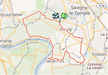
11 km | 12,8 km-effort
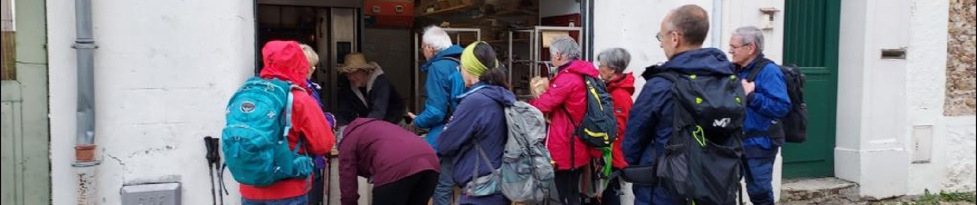
2h 59min
![](https://static1.geolcdn.com/siteimages/upload/files/16400158638029165_repeat_loop_refresh_sync_direction_icon.png)
No
![Excursión Senderismo Cesson - JC 20 19.50 km - Cesson la Forêt, forêt de Bréviande - Photo](https://media.geolcdn.com/t/375/260/a57f3f1c-b363-4986-b848-ebc6a7416d96.jpg&format=jpg&maxdim=2)
![Senderismo Senderismo](https://static1.geolcdn.com/sitytour/trail-icons/101.png)
JC 20 19.50 km - Cesson la Forêt, forêt de Bréviande
Senderismo
Difícil
(2)
Cesson,
Isla de Francia,
Sena y Marne,
France
![](/images/other/stat-length.png)
19,1 km | 21 km-effort
4h 48min
![](https://static1.geolcdn.com/siteimages/upload/files/16400158638029165_repeat_loop_refresh_sync_direction_icon.png)
Sí
![Excursión Senderismo Cesson - 2020-09-30_18h09m29_JaINFIZemJ8 - Photo](https://media.geolcdn.com/t/375/260/204fcfa0-de27-435f-8136-b0f0ee7ffa56.jpg&format=jpg&maxdim=2)
![Senderismo Senderismo](https://static1.geolcdn.com/sitytour/trail-icons/101.png)
2020-09-30_18h09m29_JaINFIZemJ8
Senderismo
Medio
(1)
Cesson,
Isla de Francia,
Sena y Marne,
France
![](/images/other/stat-length.png)
11,5 km | 13 km-effort
2h 56min
![](https://static1.geolcdn.com/siteimages/upload/files/16400158638029165_repeat_loop_refresh_sync_direction_icon.png)
Sí
![Excursión Carrera Seine-Port - Fore?t de Rougeau et bords de Seine - Photo](https://media.geolcdn.com/t/375/260/ext.jpg?maxdim=2&url=https%3A%2F%2Fservices.sitytrail.com%2FGeolivesWS%2FDownloadMedia.ashx%3FTrailID%3D105548%26Media%3D9311_1.jpg)
![Carrera Carrera](https://static1.geolcdn.com/sitytour/trail-icons/103.png)
Fore?t de Rougeau et bords de Seine
Carrera
Muy difícil
(2)
Seine-Port,
Isla de Francia,
Sena y Marne,
France
![](/images/other/stat-length.png)
28 km | 32 km-effort
3h 30min
![](https://static1.geolcdn.com/siteimages/upload/files/16400158638029165_repeat_loop_refresh_sync_direction_icon.png)
No
![Excursión Senderismo Saint-Fargeau-Ponthierry - Boucle 20 km Saint Fargeau - Photo](https://media.geolcdn.com/t/375/260/1121cafc-c79f-4e4a-a841-485665e96120.jpg&format=jpg&maxdim=2)
![Senderismo Senderismo](https://static1.geolcdn.com/sitytour/trail-icons/101.png)
Boucle 20 km Saint Fargeau
Senderismo
Fácil
Saint-Fargeau-Ponthierry,
Isla de Francia,
Sena y Marne,
France
![](/images/other/stat-length.png)
21 km | 23 km-effort
4h 34min
![](https://static1.geolcdn.com/siteimages/upload/files/16400158638029165_repeat_loop_refresh_sync_direction_icon.png)
Sí
![Excursión A pie Seine-Port - L 52 Les sentes de Seine Port - Photo](https://media.geolcdn.com/t/375/260/ext.jpg?maxdim=2&url=https%3A%2F%2Fstatic1.geolcdn.com%2Fsiteimages%2Fupload%2Ffiles%2F1545311037marcheuse_200dpi.jpg)
![A pie A pie](https://static1.geolcdn.com/sitytour/trail-icons/100.png)
L 52 Les sentes de Seine Port
A pie
Fácil
(1)
Seine-Port,
Isla de Francia,
Sena y Marne,
France
![](/images/other/stat-length.png)
7,3 km | 8,8 km-effort
2h 0min
![](https://static1.geolcdn.com/siteimages/upload/files/16400158638029165_repeat_loop_refresh_sync_direction_icon.png)
Sí
![Excursión Senderismo Vert-Saint-Denis - 20220330 - Forêt de Bréviande 15km - Photo](https://media.geolcdn.com/t/375/260/ext.jpg?maxdim=2&url=https%3A%2F%2Fstatic1.geolcdn.com%2Fsiteimages%2Fupload%2Ffiles%2F1553511878bg_sport_marche.png)
![Senderismo Senderismo](https://static1.geolcdn.com/sitytour/trail-icons/101.png)
20220330 - Forêt de Bréviande 15km
Senderismo
Difícil
(1)
Vert-Saint-Denis,
Isla de Francia,
Sena y Marne,
France
![](/images/other/stat-length.png)
14,6 km | 16,3 km-effort
3h 42min
![](https://static1.geolcdn.com/siteimages/upload/files/16400158638029165_repeat_loop_refresh_sync_direction_icon.png)
Sí
![Excursión Senderismo Seine-Port - Boucle autour de Seine Port - Photo](https://media.geolcdn.com/t/375/260/b70a8046-66e0-4a4e-815c-b510f5b883d5.jpg&format=jpg&maxdim=2)
![Senderismo Senderismo](https://static1.geolcdn.com/sitytour/trail-icons/101.png)
Boucle autour de Seine Port
Senderismo
Muy fácil
Seine-Port,
Isla de Francia,
Sena y Marne,
France
![](/images/other/stat-length.png)
22 km | 25 km-effort
4h 48min
![](https://static1.geolcdn.com/siteimages/upload/files/16400158638029165_repeat_loop_refresh_sync_direction_icon.png)
Sí
![Excursión Senderismo Nandy - 2017-10-05-Cesson - Photo](https://media.geolcdn.com/t/375/260/ext.jpg?maxdim=2&url=https%3A%2F%2Fstatic1.geolcdn.com%2Fsiteimages%2Fupload%2Ffiles%2F1553511878bg_sport_marche.png)
![Senderismo Senderismo](https://static1.geolcdn.com/sitytour/trail-icons/101.png)
2017-10-05-Cesson
Senderismo
Difícil
(1)
Nandy,
Isla de Francia,
Sena y Marne,
France
![](/images/other/stat-length.png)
21 km | 24 km-effort
5h 32min
![](https://static1.geolcdn.com/siteimages/upload/files/16400158638029165_repeat_loop_refresh_sync_direction_icon.png)
Sí