![](/images/other/stat-length.png)
#200420 - Chaumont-Gistoux, Ronvaux, Pré Delcourt, Babaures***
Randos Ouvertes
Usuario
![Longitud](/images/other/stat-length.png)
![Altitud máxima](https://static1.geolcdn.com/siteimages/upload/files/1508320355ic_sort_altitude_max_24dp.png)
![Desnivel positivo](https://static1.geolcdn.com/siteimages/upload/files/1508320355ic_sort_den_pos_24dp.png)
![Km-Effort](/images/other/stat-length.png)
![Altitud mínima](https://static1.geolcdn.com/siteimages/upload/files/1508320355ic_sort_altitude_min_24dp.png)
![Desnivel negativo](https://static1.geolcdn.com/siteimages/upload/files/1508320355ic_sort_den_neg_24dp.png)
![Boucle](https://static1.geolcdn.com/siteimages/upload/files/16400158638029165_repeat_loop_refresh_sync_direction_icon.png)
![Senderismo](https://static1.geolcdn.com/sitytour/trail-icons/101.png)
2h10
Dificultad : Medio
![Escanee este código QR para abrir la excursión en la aplicación SityTrail](https://capi.geolives.com/qq0zvz2zws4bq2lad0pu/sitytour/trails/2989040/qr.png?size=200)
Aplicación GPS de excursión GRATIS
A propósito
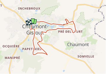
Ruta Senderismo de 7,7 km a descubrir en Valonia, Brabante Valón, Chaumont-Gistoux. Esta ruta ha sido propuesta por Randos Ouvertes.
Descripción
Belle marche à travers la réserve naturelle du Ronvaux. Montée très difficile en bordure de l'ancienne carrière (centre sportif). Traversée de prairie par tourniquets au Pré Delcourt.
Index des lieux et toponymie
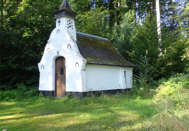
Égise Saint-Jean Baptiste
Rue de Wavre
Sentier 71 (Rwalète) **
Le Train
Allée Eddy du Perron
Ry du Pré Delcourt
Avenue du Ronvaux **
Centre Sportif Docquier
Moulin Blanc (Debienne) ***
Sentier du vicinal Courcelles Incourt
Sentier des Vignes ***
Rue des Vignes
Rue Champtaine
Sentier du Pré Delcourt **
Pré Delcourt
Sentier n° 87
Rue des Bovrées
Voie des Vaches **
Rue Ferme du Mont
Rue des Babaures
Al Babaure
Rue de Tourinnes
Pas-de-Chien
Chemin n° 8
Chemin n° 38
Chemin n° 37
Rue des Papeteries
Rue Zaine
Maison communale
Rue de Wavre
Puntos de interés
Localización
Comentarios
Excursiones cerca
![Excursión Senderismo Chaumont-Gistoux - De Dion-le Mont à Dion-le Val par la vallée du Pisselet - Photo](https://media.geolcdn.com/t/375/260/ext.jpg?maxdim=2&url=https%3A%2F%2Fstatic1.geolcdn.com%2Fsiteimages%2Fupload%2Ffiles%2F1553511878bg_sport_marche.png)
![Senderismo Senderismo](https://static1.geolcdn.com/sitytour/trail-icons/101.png)
Senderismo
![](/images/other/stat-length.png)
![](https://static1.geolcdn.com/siteimages/upload/files/16400158638029165_repeat_loop_refresh_sync_direction_icon.png)
![Senderismo Senderismo](https://static1.geolcdn.com/sitytour/trail-icons/101.png)
Senderismo
![](/images/other/stat-length.png)
![](https://static1.geolcdn.com/siteimages/upload/files/16400158638029165_repeat_loop_refresh_sync_direction_icon.png)
![Excursión Senderismo Chaumont-Gistoux - BE-Chaumont-Gistoux - Vieusart - Photo](https://media.geolcdn.com/t/375/260/8d29a104-ec49-41f1-a812-8df11e0d7db1.jpg&format=jpg&maxdim=2)
![Senderismo Senderismo](https://static1.geolcdn.com/sitytour/trail-icons/101.png)
Senderismo
![](/images/other/stat-length.png)
![](https://static1.geolcdn.com/siteimages/upload/files/16400158638029165_repeat_loop_refresh_sync_direction_icon.png)
![Excursión Senderismo Wavre - RB-BW-07 - Des montagnes russes près de Wavre - Photo](https://media.geolcdn.com/t/375/260/ext.jpg?maxdim=2&url=https%3A%2F%2Fservices.sitytrail.com%2FGeolivesWS%2FDownloadMedia.ashx%3FTrailID%3D179582%26Media%3D72f18e5f-b96b-4732-9bbe-457fabd000c2.jpg)
![Senderismo Senderismo](https://static1.geolcdn.com/sitytour/trail-icons/101.png)
Senderismo
![](/images/other/stat-length.png)
![](https://static1.geolcdn.com/siteimages/upload/files/16400158638029165_repeat_loop_refresh_sync_direction_icon.png)
![Senderismo Senderismo](https://static1.geolcdn.com/sitytour/trail-icons/101.png)
Senderismo
![](/images/other/stat-length.png)
![](https://static1.geolcdn.com/siteimages/upload/files/16400158638029165_repeat_loop_refresh_sync_direction_icon.png)
![Excursión Senderismo Chaumont-Gistoux - #231016 - Corroy-Le-Grand et le Val d'Ocquière*** (inversé court) - Photo](https://media.geolcdn.com/t/375/260/b650de28-d96e-49f2-85c2-d640aecfc352.jpg&format=jpg&maxdim=2)
![Senderismo Senderismo](https://static1.geolcdn.com/sitytour/trail-icons/101.png)
Senderismo
![](/images/other/stat-length.png)
![](https://static1.geolcdn.com/siteimages/upload/files/16400158638029165_repeat_loop_refresh_sync_direction_icon.png)
![Senderismo Senderismo](https://static1.geolcdn.com/sitytour/trail-icons/101.png)
Senderismo
![](/images/other/stat-length.png)
![](https://static1.geolcdn.com/siteimages/upload/files/16400158638029165_repeat_loop_refresh_sync_direction_icon.png)
![Senderismo Senderismo](https://static1.geolcdn.com/sitytour/trail-icons/101.png)
Senderismo
![](/images/other/stat-length.png)
![](https://static1.geolcdn.com/siteimages/upload/files/16400158638029165_repeat_loop_refresh_sync_direction_icon.png)
![A pie A pie](https://static1.geolcdn.com/sitytour/trail-icons/100.png)
A pie
![](/images/other/stat-length.png)
![](https://static1.geolcdn.com/siteimages/upload/files/16400158638029165_repeat_loop_refresh_sync_direction_icon.png)