![](/images/other/stat-length.png)
![Excursión Senderismo Bessèges - Bessèges - Le RONC ROUGE - Photo](https://media.geolcdn.com/t/1900/400/ext.pjpeg?maxdim=2&url=https%3A%2F%2Fstatic1.geolcdn.com%2Fsiteimages%2Fupload%2Ffiles%2F1553511878bg_sport_marche.png)
Bessèges - Le RONC ROUGE
GOIOLIRIBES
Usuario
![Longitud](/images/other/stat-length.png)
Longitud
9,8 km
![Altitud máxima](https://static1.geolcdn.com/siteimages/upload/files/1508320355ic_sort_altitude_max_24dp.png)
Altitud máxima
419 m
![Desnivel positivo](https://static1.geolcdn.com/siteimages/upload/files/1508320355ic_sort_den_pos_24dp.png)
Desnivel positivo
326 m
![Km-Effort](/images/other/stat-length.png)
Km-Effort
14,1 km
![Altitud mínima](https://static1.geolcdn.com/siteimages/upload/files/1508320355ic_sort_altitude_min_24dp.png)
Altitud mínima
165 m
![Desnivel negativo](https://static1.geolcdn.com/siteimages/upload/files/1508320355ic_sort_den_neg_24dp.png)
Desnivel negativo
326 m
![Boucle](https://static1.geolcdn.com/siteimages/upload/files/16400158638029165_repeat_loop_refresh_sync_direction_icon.png)
Boucle
Sí
Fecha de creación :
2021-10-28 07:44:47.985
Última modificación :
2021-10-29 05:55:12.546
![Senderismo](https://static1.geolcdn.com/sitytour/trail-icons/101.png)
4h42
Dificultad : Difícil
![Escanee este código QR para abrir la excursión en la aplicación SityTrail](https://capi.geolives.com/qq0zvz2zws4bq2lad0pu/sitytour/trails/2985534/qr.png?size=200)
Aplicación GPS de excursión GRATIS
A propósito
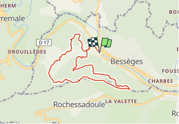
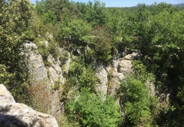
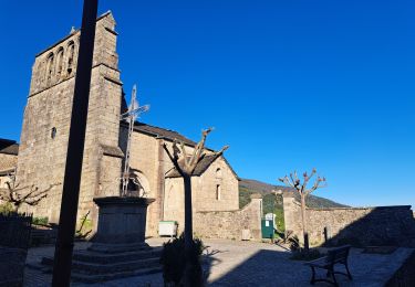
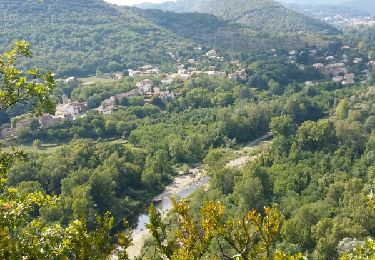
Ruta Senderismo de 9,8 km a descubrir en Occitania, Gard, Bessèges. Esta ruta ha sido propuesta por GOIOLIRIBES.
Descripción
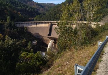
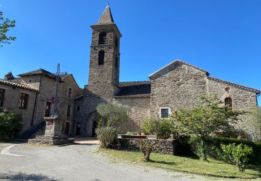
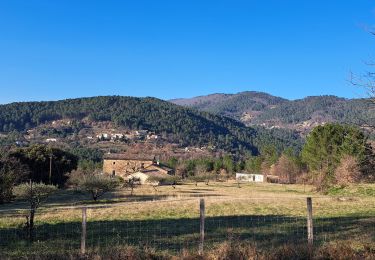
Stationner sur le Parking face hôtel de ville. Bonne montée dès le départ - randonnée courte mais agréable, sous les châtaigniers en partie, et vue à 360° depuis la chapelle.
temps de marche compris avec pause casse croûte.
Localización
País:
France
Región :
Occitania
Departamento/provincia :
Gard
Municipio :
Bessèges
Localidad:
Unknown
Salida:(Dec)
Salida:(UTM)
587286 ; 4904864 (31T) N.
Comentarios
Excursiones cerca
![Excursión Senderismo Saint-Paul-le-Jeune - résurgence de cotepatiere ( cocalhere) - Photo](https://media.geolcdn.com/t/375/260/ext.jpg?maxdim=2&url=https%3A%2F%2Fservices.sitytrail.com%2FGeolivesWS%2FDownloadMedia.ashx%3FTrailID%3D897616%26Media%3D20170509140453.jpg)
![Senderismo Senderismo](https://static1.geolcdn.com/sitytour/trail-icons/101.png)
résurgence de cotepatiere ( cocalhere)
Senderismo
Muy fácil
(1)
Saint-Paul-le-Jeune,
Auvergne-Rhône-Alpes,
Ardecha,
France
![](/images/other/stat-length.png)
12,9 km | 15,1 km-effort
4h 46min
![](https://static1.geolcdn.com/siteimages/upload/files/16400158638029165_repeat_loop_refresh_sync_direction_icon.png)
Sí
![Excursión Senderismo Bessèges - GRP Haute Vallée de la Cèze - Photo](https://media.geolcdn.com/t/375/260/49a90d29-4f4f-4259-a0bb-bdd47eb85dfd.jpg&format=jpg&maxdim=2)
![Senderismo Senderismo](https://static1.geolcdn.com/sitytour/trail-icons/101.png)
GRP Haute Vallée de la Cèze
Senderismo
Muy difícil
Bessèges,
Occitania,
Gard,
France
![](/images/other/stat-length.png)
21 km | 36 km-effort
7h 57min
![](https://static1.geolcdn.com/siteimages/upload/files/16400158638029165_repeat_loop_refresh_sync_direction_icon.png)
No
![Excursión Senderismo Molières-sur-Cèze - moliere sur ceze - Photo](https://media.geolcdn.com/t/375/260/ext.jpg?maxdim=2&url=https%3A%2F%2Fservices.sitytrail.com%2FGeolivesWS%2FDownloadMedia.ashx%3FTrailID%3D464703%26Media%3Dfix__20150827165221.jpg)
![Senderismo Senderismo](https://static1.geolcdn.com/sitytour/trail-icons/101.png)
moliere sur ceze
Senderismo
Fácil
(2)
Molières-sur-Cèze,
Occitania,
Gard,
France
![](/images/other/stat-length.png)
4,6 km | 6,1 km-effort
2h 6min
![](https://static1.geolcdn.com/siteimages/upload/files/16400158638029165_repeat_loop_refresh_sync_direction_icon.png)
Sí
![Excursión Bici de carretera Bessèges - 30 Bessèges aujac - Photo](https://media.geolcdn.com/t/375/260/de56a610-05a8-4545-9c52-1c2de0a625a9.jpg&format=jpg&maxdim=2)
![Bici de carretera Bici de carretera](https://static1.geolcdn.com/sitytour/trail-icons/201.png)
30 Bessèges aujac
Bici de carretera
Medio
Bessèges,
Occitania,
Gard,
France
![](/images/other/stat-length.png)
56 km | 70 km-effort
3h 50min
![](https://static1.geolcdn.com/siteimages/upload/files/16400158638029165_repeat_loop_refresh_sync_direction_icon.png)
Sí
![Excursión Senderismo Bessèges - Besseges Aujac GR pays - Photo](https://media.geolcdn.com/t/375/260/8e000c02-b340-43fb-bfed-599b5d224f4b.jpg&format=jpg&maxdim=2)
![Senderismo Senderismo](https://static1.geolcdn.com/sitytour/trail-icons/101.png)
Besseges Aujac GR pays
Senderismo
Muy difícil
Bessèges,
Occitania,
Gard,
France
![](/images/other/stat-length.png)
23 km | 37 km-effort
10h 3min
![](https://static1.geolcdn.com/siteimages/upload/files/16400158638029165_repeat_loop_refresh_sync_direction_icon.png)
No
![Excursión Senderismo Saint-Paul-le-Jeune - randonnee des combes blancs - Photo](https://media.geolcdn.com/t/375/260/4cd32eaa-0c21-4e0a-ba4c-d6f6ee7b6d4d.jpg&format=jpg&maxdim=2)
![Senderismo Senderismo](https://static1.geolcdn.com/sitytour/trail-icons/101.png)
randonnee des combes blancs
Senderismo
Fácil
Saint-Paul-le-Jeune,
Auvergne-Rhône-Alpes,
Ardecha,
France
![](/images/other/stat-length.png)
10,1 km | 12 km-effort
3h 52min
![](https://static1.geolcdn.com/siteimages/upload/files/16400158638029165_repeat_loop_refresh_sync_direction_icon.png)
Sí
![Excursión Senderismo Bordezac - Les crêtes d'Aujac - Photo](https://media.geolcdn.com/t/375/260/7d4e3deb-fb72-489d-b982-f5465e0824e1.jpg&format=jpg&maxdim=2)
![Senderismo Senderismo](https://static1.geolcdn.com/sitytour/trail-icons/101.png)
Les crêtes d'Aujac
Senderismo
Muy difícil
(1)
Bordezac,
Occitania,
Gard,
France
![](/images/other/stat-length.png)
22 km | 33 km-effort
6h 17min
![](https://static1.geolcdn.com/siteimages/upload/files/16400158638029165_repeat_loop_refresh_sync_direction_icon.png)
Sí
![Excursión Senderismo Bessèges - besseges - Photo](https://media.geolcdn.com/t/375/260/b7b6e9f7-3c18-465b-85dc-65707369d569.jpg&format=jpg&maxdim=2)
![Senderismo Senderismo](https://static1.geolcdn.com/sitytour/trail-icons/101.png)
![Excursión Bici de carretera Bessèges - 30 foussignargue vélo - Photo](https://media.geolcdn.com/t/375/260/1cb4abac-8889-4636-a0b8-2ea194647c01.jpg&format=jpg&maxdim=2)
![Bici de carretera Bici de carretera](https://static1.geolcdn.com/sitytour/trail-icons/201.png)
30 foussignargue vélo
Bici de carretera
Medio
Bessèges,
Occitania,
Gard,
France
![](/images/other/stat-length.png)
58 km | 68 km-effort
3h 52min
![](https://static1.geolcdn.com/siteimages/upload/files/16400158638029165_repeat_loop_refresh_sync_direction_icon.png)
Sí