![](/images/other/stat-length.png)
![Excursión Senderismo Marsella - Callelongue - Corniche Salis - Pas de Gracia - Grotte Roland - Photo](https://media.geolcdn.com/t/1900/400/d72c5290-5263-4f02-8e3a-fe942617aefa.jpg&format=pjpeg&maxdim=2)
Callelongue - Corniche Salis - Pas de Gracia - Grotte Roland
fhascoet
Usuario
![Longitud](/images/other/stat-length.png)
![Altitud máxima](https://static1.geolcdn.com/siteimages/upload/files/1508320355ic_sort_altitude_max_24dp.png)
![Desnivel positivo](https://static1.geolcdn.com/siteimages/upload/files/1508320355ic_sort_den_pos_24dp.png)
![Km-Effort](/images/other/stat-length.png)
![Altitud mínima](https://static1.geolcdn.com/siteimages/upload/files/1508320355ic_sort_altitude_min_24dp.png)
![Desnivel negativo](https://static1.geolcdn.com/siteimages/upload/files/1508320355ic_sort_den_neg_24dp.png)
![Boucle](https://static1.geolcdn.com/siteimages/upload/files/16400158638029165_repeat_loop_refresh_sync_direction_icon.png)
![Senderismo](https://static1.geolcdn.com/sitytour/trail-icons/101.png)
3h04
Dificultad : Medio
![Escanee este código QR para abrir la excursión en la aplicación SityTrail](https://capi.geolives.com/qq0zvz2zws4bq2lad0pu/sitytour/trails/2981044/qr.png?size=200)
Aplicación GPS de excursión GRATIS
A propósito
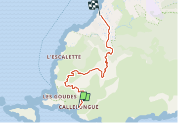
Ruta Senderismo de 6 km a descubrir en Provenza-Alpes-Costa Azul, Bocas del Ródano, Marsella. Esta ruta ha sido propuesta por fhascoet.
Descripción
Randonnée de 3 heures entre Callelongue et le quartier de la Grotte Rolland
Accès à Callelongue depuis le centre ville, par le bus 20 puis le bus 19. Retour par le bus 20
On démarre par le GR puis on le quitte pour prendre la Corniche Salis ( noir pointillé).
Au col de Moutte on prends le sentier jaune qui fait le tour de la pointe. Avant d'arriver à Beouveyre, partir à gauche dans un chemin bien marqué vers le pas de Gracia puis le sommet. On redescend de Beouveyre par le tracé vert (assez raide et il faut parfois mettre les mains)
Localización
Comentarios
Excursiones cerca
![Excursión Bici de montaña Marsella - OR-6270829--Marseille:Trilogie des Calanques - Photo](https://media.geolcdn.com/t/375/260/37b85b5c-5918-4ab9-a017-9d4bcff1fa49.jpg&format=jpg&maxdim=2)
![Bici de montaña Bici de montaña](https://static1.geolcdn.com/sitytour/trail-icons/202.png)
Bici de montaña
![](/images/other/stat-length.png)
![](https://static1.geolcdn.com/siteimages/upload/files/16400158638029165_repeat_loop_refresh_sync_direction_icon.png)
![Excursión Senderismo Marsella - Marseilleveyre - Photo](https://media.geolcdn.com/t/375/260/1c6dd8e4-fc3d-455d-ab0a-aecb3f4e28f3.jpg&format=jpg&maxdim=2)
![Senderismo Senderismo](https://static1.geolcdn.com/sitytour/trail-icons/101.png)
Senderismo
![](/images/other/stat-length.png)
![](https://static1.geolcdn.com/siteimages/upload/files/16400158638029165_repeat_loop_refresh_sync_direction_icon.png)
![Excursión A pie Marsella - FR-4 - Photo](https://media.geolcdn.com/t/375/260/95b4ab9b-15fa-4206-9283-bece755bce28.jpeg&format=jpg&maxdim=2)
![A pie A pie](https://static1.geolcdn.com/sitytour/trail-icons/100.png)
A pie
![](/images/other/stat-length.png)
![](https://static1.geolcdn.com/siteimages/upload/files/16400158638029165_repeat_loop_refresh_sync_direction_icon.png)
![Excursión A pie Marsella - FR-1 - Photo](https://media.geolcdn.com/t/375/260/bc3bf1c1-4e6d-4ecd-b741-b7754447ebb3.jpeg&format=jpg&maxdim=2)
![A pie A pie](https://static1.geolcdn.com/sitytour/trail-icons/100.png)
A pie
![](/images/other/stat-length.png)
![](https://static1.geolcdn.com/siteimages/upload/files/16400158638029165_repeat_loop_refresh_sync_direction_icon.png)
![Excursión A pie Marsella - FR-1 - Photo](https://media.geolcdn.com/t/375/260/99184d8a-cb78-4a50-b5ed-c50326639dce.jpeg&format=jpg&maxdim=2)
![A pie A pie](https://static1.geolcdn.com/sitytour/trail-icons/100.png)
A pie
![](/images/other/stat-length.png)
![](https://static1.geolcdn.com/siteimages/upload/files/16400158638029165_repeat_loop_refresh_sync_direction_icon.png)
![Excursión A pie Marsella - FR-1 - Photo](https://media.geolcdn.com/t/375/260/bc3bf1c1-4e6d-4ecd-b741-b7754447ebb3.jpeg&format=jpg&maxdim=2)
![A pie A pie](https://static1.geolcdn.com/sitytour/trail-icons/100.png)
A pie
![](/images/other/stat-length.png)
![](https://static1.geolcdn.com/siteimages/upload/files/16400158638029165_repeat_loop_refresh_sync_direction_icon.png)
![Excursión A pie Marsella - FR-1 - Photo](https://media.geolcdn.com/t/375/260/4cd62a7f-c9ca-4a0b-a61b-53cee5136735.jpeg&format=jpg&maxdim=2)
![A pie A pie](https://static1.geolcdn.com/sitytour/trail-icons/100.png)
A pie
![](/images/other/stat-length.png)
![](https://static1.geolcdn.com/siteimages/upload/files/16400158638029165_repeat_loop_refresh_sync_direction_icon.png)
![Excursión A pie Marsella - FR-2 - Photo](https://media.geolcdn.com/t/375/260/4e6398b1-8b18-413e-9aa3-3eda435bcb35.jpeg&format=jpg&maxdim=2)
![A pie A pie](https://static1.geolcdn.com/sitytour/trail-icons/100.png)
A pie
![](/images/other/stat-length.png)
![](https://static1.geolcdn.com/siteimages/upload/files/16400158638029165_repeat_loop_refresh_sync_direction_icon.png)
![Excursión A pie Marsella - FR-2 - Photo](https://media.geolcdn.com/t/375/260/95b4ab9b-15fa-4206-9283-bece755bce28.jpeg&format=jpg&maxdim=2)
![A pie A pie](https://static1.geolcdn.com/sitytour/trail-icons/100.png)
A pie
![](/images/other/stat-length.png)
![](https://static1.geolcdn.com/siteimages/upload/files/16400158638029165_repeat_loop_refresh_sync_direction_icon.png)