![](/images/other/stat-length.png)
![Excursión Senderismo Meux - Les moulins à Meux en terres de Champagne - Photo](https://media.geolcdn.com/t/1900/400/ext.pjpeg?maxdim=2&url=https%3A%2F%2Fstatic1.geolcdn.com%2Fsiteimages%2Fupload%2Ffiles%2F1553511878bg_sport_marche.png)
Les moulins à Meux en terres de Champagne
neoroll44
Usuario
![Longitud](/images/other/stat-length.png)
![Altitud máxima](https://static1.geolcdn.com/siteimages/upload/files/1508320355ic_sort_altitude_max_24dp.png)
![Desnivel positivo](https://static1.geolcdn.com/siteimages/upload/files/1508320355ic_sort_den_pos_24dp.png)
![Km-Effort](/images/other/stat-length.png)
![Altitud mínima](https://static1.geolcdn.com/siteimages/upload/files/1508320355ic_sort_altitude_min_24dp.png)
![Desnivel negativo](https://static1.geolcdn.com/siteimages/upload/files/1508320355ic_sort_den_neg_24dp.png)
![Boucle](https://static1.geolcdn.com/siteimages/upload/files/16400158638029165_repeat_loop_refresh_sync_direction_icon.png)
![Senderismo](https://static1.geolcdn.com/sitytour/trail-icons/101.png)
3h30
Dificultad : Difícil
![Escanee este código QR para abrir la excursión en la aplicación SityTrail](https://capi.geolives.com/qq0zvz2zws4bq2lad0pu/sitytour/trails/2976863/qr.png?size=200)
Aplicación GPS de excursión GRATIS
A propósito
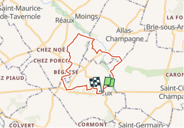
Ruta Senderismo de 12,7 km a descubrir en Nueva Aquitania, Charente-Maritime, Meux. Esta ruta ha sido propuesta por neoroll44.
Descripción
Parking : place de la mairie de Meux.
(D) Au départ de la place de la mairie, longer la départementale vers la droite (accotement sécurisé), puis descendre à droite le long de l'école et du terrain de football en suivant les balises Jaunes numérotées "5". Passer à travers bois et tourner à gauche en lisière, prendre la route à droite.
(1) Au carrefour des chemins, entrer dans le bois à gauche, tourner à droite deux fois et ressortir. Tourner à gauche, après un bref passage en sous-bois, poursuivre en lisière jusqu'à la route.
(2) Après la combe, au carrefour, conserver la même direction et monter vers la Grande Rente et le Calvaire des Moulins. Au château d'eau, poursuivre à droite sur le coteau vers un ancien moulin.
(3) Tourner à droite sur la D249, puis sur un chemin herbeux descendant entre les vignes à droite. Au lieu-dit Chez Poineau, partir à gauche puis, au lieu-dit chez Bégasse, prendre le chemin descendant à droite en lisière et en sous-bois.
(4) Longer à gauche la D249. Face à chez Bergeon, passer à droite entre les vignes vers chez Piconnet. Continuer vers un bois. Après chez Bégouin, suivre le chemin de droite vers le Ruisseau le Trèfle (à droite, la Cannonerie, ancien pavillon de chasse de François 1er).
(5) Emprunter la deuxième petite route à droite qui se rapproche du Trèfle. Après le Moulin à eau du Périer, tourner à droite et monter au Bois d'Archat. Passer à gauche entre les maisons, puis continuer en sous-bois en virant à gauche sur une ancienne voie ferrée.
(6) Prendre la route à droite, puis tourner à gauche sur la D149. Au croisement, continuer tout droit sur un sentier entre les peupleraies du Tâtre et du Trèfle. S'approcher du hameau de chez Nocent.
(7) Prendre à droite vers le ruisseau à 200m, traverser et monter à droite vers chez Pichet.
(8)Traverser la route et rejoindre le Ruisseau du Tâtre puis prendre à gauche jusqu'au moulin à eau de chez Chiron. Tourner à droite pour traverser le Tâtre et monter enfin vers le Château de Meux. A la route, aller à gauche jusqu'à l'église.
(9) Tourner alors à droite, longer l'église et rejoindre le point de départ (D/A).
Puntos de interés
Localización
Comentarios
Excursiones cerca
![Excursión Senderismo Champagnac - roro - Photo](https://media.geolcdn.com/t/375/260/ext.jpg?maxdim=2&url=https%3A%2F%2Fstatic1.geolcdn.com%2Fsiteimages%2Fupload%2Ffiles%2F1553511878bg_sport_marche.png)
![Senderismo Senderismo](https://static1.geolcdn.com/sitytour/trail-icons/101.png)
Senderismo
![](/images/other/stat-length.png)
![](https://static1.geolcdn.com/siteimages/upload/files/16400158638029165_repeat_loop_refresh_sync_direction_icon.png)
![Excursión Senderismo Réaux-sur-Trèfle - Le Trèfle entre Viveronne et Tâtre - Photo](https://media.geolcdn.com/t/375/260/ext.jpg?maxdim=2&url=https%3A%2F%2Fstatic1.geolcdn.com%2Fsiteimages%2Fupload%2Ffiles%2F1553511878bg_sport_marche.png)
![Senderismo Senderismo](https://static1.geolcdn.com/sitytour/trail-icons/101.png)
Senderismo
![](/images/other/stat-length.png)
![](https://static1.geolcdn.com/siteimages/upload/files/16400158638029165_repeat_loop_refresh_sync_direction_icon.png)
![Excursión Coche Jonzac - Tirage chez Viner - Photo](https://media.geolcdn.com/t/375/260/ext.jpg?maxdim=2&url=https%3A%2F%2Fstatic1.geolcdn.com%2Fsiteimages%2Fupload%2Ffiles%2F15247431544x4.jpg)
![Coche Coche](https://static1.geolcdn.com/sitytour/trail-icons/401.png)
Coche
![](/images/other/stat-length.png)
![](https://static1.geolcdn.com/siteimages/upload/files/16400158638029165_repeat_loop_refresh_sync_direction_icon.png)
![Excursión A pie Allas-Champagne - Téléthon 2019 - Photo](https://media.geolcdn.com/t/375/260/ext.jpg?maxdim=2&url=https%3A%2F%2Fstatic1.geolcdn.com%2Fsiteimages%2Fupload%2Ffiles%2F1545311037marcheuse_200dpi.jpg)
![A pie A pie](https://static1.geolcdn.com/sitytour/trail-icons/100.png)
A pie
![](/images/other/stat-length.png)
![](https://static1.geolcdn.com/siteimages/upload/files/16400158638029165_repeat_loop_refresh_sync_direction_icon.png)
![Excursión Senderismo Réaux-sur-Trèfle - moings - Photo](https://media.geolcdn.com/t/375/260/ext.jpg?maxdim=2&url=https%3A%2F%2Fstatic1.geolcdn.com%2Fsiteimages%2Fupload%2Ffiles%2F1553511878bg_sport_marche.png)
![Senderismo Senderismo](https://static1.geolcdn.com/sitytour/trail-icons/101.png)
Senderismo
![](/images/other/stat-length.png)
![](https://static1.geolcdn.com/siteimages/upload/files/16400158638029165_repeat_loop_refresh_sync_direction_icon.png)
![Excursión Senderismo Meux - Meux1 - Photo](https://media.geolcdn.com/t/375/260/ext.jpg?maxdim=2&url=https%3A%2F%2Fstatic1.geolcdn.com%2Fsiteimages%2Fupload%2Ffiles%2F1553511878bg_sport_marche.png)
![Senderismo Senderismo](https://static1.geolcdn.com/sitytour/trail-icons/101.png)
Senderismo
![](/images/other/stat-length.png)
![](https://static1.geolcdn.com/siteimages/upload/files/16400158638029165_repeat_loop_refresh_sync_direction_icon.png)
![Excursión Senderismo Réaux-sur-Trèfle - reaux - Photo](https://media.geolcdn.com/t/375/260/ext.jpg?maxdim=2&url=https%3A%2F%2Fstatic1.geolcdn.com%2Fsiteimages%2Fupload%2Ffiles%2F1553511878bg_sport_marche.png)
![Senderismo Senderismo](https://static1.geolcdn.com/sitytour/trail-icons/101.png)
Senderismo
![](/images/other/stat-length.png)
![](https://static1.geolcdn.com/siteimages/upload/files/16400158638029165_repeat_loop_refresh_sync_direction_icon.png)
![Excursión Senderismo Meux - Meux - Photo](https://media.geolcdn.com/t/375/260/ext.jpg?maxdim=2&url=https%3A%2F%2Fstatic1.geolcdn.com%2Fsiteimages%2Fupload%2Ffiles%2F1553511878bg_sport_marche.png)
![Senderismo Senderismo](https://static1.geolcdn.com/sitytour/trail-icons/101.png)
Senderismo
![](/images/other/stat-length.png)
![](https://static1.geolcdn.com/siteimages/upload/files/16400158638029165_repeat_loop_refresh_sync_direction_icon.png)
![Excursión Senderismo Saint-Germain-de-Vibrac - Saint Germain de Vibrac 12 km - Photo](https://media.geolcdn.com/t/375/260/ext.jpg?maxdim=2&url=https%3A%2F%2Fstatic1.geolcdn.com%2Fsiteimages%2Fupload%2Ffiles%2F1553511878bg_sport_marche.png)
![Senderismo Senderismo](https://static1.geolcdn.com/sitytour/trail-icons/101.png)
Senderismo
![](/images/other/stat-length.png)
![](https://static1.geolcdn.com/siteimages/upload/files/16400158638029165_repeat_loop_refresh_sync_direction_icon.png)