![](/images/other/stat-length.png)
![Excursión Senderismo Péone - Peone Circuit septenne et l'Estrop - Photo](https://media.geolcdn.com/t/1900/400/a1958066-dcfa-44cb-8543-a2554aa68e70.jpg&format=pjpeg&maxdim=2)
Peone Circuit septenne et l'Estrop
GrouGary
Usuario
![Longitud](/images/other/stat-length.png)
Longitud
14,1 km
![Altitud máxima](https://static1.geolcdn.com/siteimages/upload/files/1508320355ic_sort_altitude_max_24dp.png)
Altitud máxima
2239 m
![Desnivel positivo](https://static1.geolcdn.com/siteimages/upload/files/1508320355ic_sort_den_pos_24dp.png)
Desnivel positivo
991 m
![Km-Effort](/images/other/stat-length.png)
Km-Effort
28 km
![Altitud mínima](https://static1.geolcdn.com/siteimages/upload/files/1508320355ic_sort_altitude_min_24dp.png)
Altitud mínima
1171 m
![Desnivel negativo](https://static1.geolcdn.com/siteimages/upload/files/1508320355ic_sort_den_neg_24dp.png)
Desnivel negativo
1085 m
![Boucle](https://static1.geolcdn.com/siteimages/upload/files/16400158638029165_repeat_loop_refresh_sync_direction_icon.png)
Boucle
No
Fecha de creación :
2021-10-09 06:49:47.627
Última modificación :
2021-10-10 09:25:31.576
![Senderismo](https://static1.geolcdn.com/sitytour/trail-icons/101.png)
4h56
Dificultad : Medio
![Escanee este código QR para abrir la excursión en la aplicación SityTrail](https://capi.geolives.com/qq0zvz2zws4bq2lad0pu/sitytour/trails/2963717/qr.png?size=200)
Aplicación GPS de excursión GRATIS
A propósito
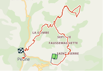
Ruta Senderismo de 14,1 km a descubrir en Provenza-Alpes-Costa Azul, Alpes Marítimos, Péone. Esta ruta ha sido propuesta por GrouGary.
Descripción
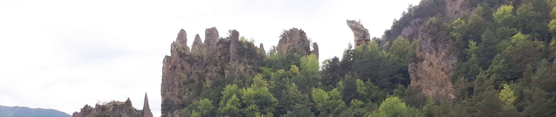
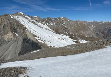
Circuit agréable dans les Alpages au-dessus de Peone. Traversée de petits hameaux restaurées.
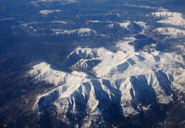
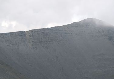
De l'Estrop, vue sur la face Sud Ouest du Mounier (Col de Crousette...)
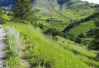
Troupeaux de Tarines paisibles sur le circuit de Septenne
Localización
País:
France
Región :
Provenza-Alpes-Costa Azul
Departamento/provincia :
Alpes Marítimos
Municipio :
Péone
Localidad:
Unknown
Salida:(Dec)
Salida:(UTM)
333774 ; 4886710 (32T) N.
Comentarios
Excursiones cerca
![Excursión Raquetas de nieve Beuil - Beuil :Rando raquettes (Aller) - Photo](https://media.geolcdn.com/t/375/260/ext.jpg?maxdim=2&url=https%3A%2F%2Fservices.sitytrail.com%2FGeolivesWS%2FDownloadMedia.ashx%3FTrailID%3D251398%26Media%3Dfix__20140221123121.jpg)
![Raquetas de nieve Raquetas de nieve](https://static1.geolcdn.com/sitytour/trail-icons/504.png)
Beuil :Rando raquettes (Aller)
Raquetas de nieve
Fácil
(2)
Beuil,
Provenza-Alpes-Costa Azul,
Alpes Marítimos,
France
![](/images/other/stat-length.png)
4,3 km | 6,6 km-effort
1h 40min
![](https://static1.geolcdn.com/siteimages/upload/files/16400158638029165_repeat_loop_refresh_sync_direction_icon.png)
No
![Excursión A pie Guillaumes - Sentier Planétaire - Photo](https://media.geolcdn.com/t/375/260/e96398fb-c06d-4a8f-b157-fc349cbf3cc7.jpeg&format=jpg&maxdim=2)
![A pie A pie](https://static1.geolcdn.com/sitytour/trail-icons/100.png)
Sentier Planétaire
A pie
Fácil
Guillaumes,
Provenza-Alpes-Costa Azul,
Alpes Marítimos,
France
![](/images/other/stat-length.png)
9,2 km | 13 km-effort
2h 57min
![](https://static1.geolcdn.com/siteimages/upload/files/16400158638029165_repeat_loop_refresh_sync_direction_icon.png)
Sí
![Excursión A pie Beuil - Tête du Garnier - Photo](https://media.geolcdn.com/t/375/260/8afc2979-1909-4f36-ba82-f331af4dab5f.jpeg&format=jpg&maxdim=2)
![A pie A pie](https://static1.geolcdn.com/sitytour/trail-icons/100.png)
Tête du Garnier
A pie
Fácil
Beuil,
Provenza-Alpes-Costa Azul,
Alpes Marítimos,
France
![](/images/other/stat-length.png)
11,2 km | 17,8 km-effort
4h 3min
![](https://static1.geolcdn.com/siteimages/upload/files/16400158638029165_repeat_loop_refresh_sync_direction_icon.png)
Sí
![Excursión A pie Péone - Circuit de Septenne - Photo](https://media.geolcdn.com/t/375/260/ece6b3bc-3f52-4b23-955d-de7c74062137.jpeg&format=jpg&maxdim=2)
![A pie A pie](https://static1.geolcdn.com/sitytour/trail-icons/100.png)
Circuit de Septenne
A pie
Fácil
Péone,
Provenza-Alpes-Costa Azul,
Alpes Marítimos,
France
![](/images/other/stat-length.png)
11 km | 19,2 km-effort
4h 21min
![](https://static1.geolcdn.com/siteimages/upload/files/16400158638029165_repeat_loop_refresh_sync_direction_icon.png)
Sí
![Excursión A pie Péone - Mont Mounier - Photo](https://media.geolcdn.com/t/375/260/0744a5ed-7dbe-4b82-ab9f-b5b91c9c9b14.jpeg&format=jpg&maxdim=2)
![A pie A pie](https://static1.geolcdn.com/sitytour/trail-icons/100.png)
Mont Mounier
A pie
Difícil
Péone,
Provenza-Alpes-Costa Azul,
Alpes Marítimos,
France
![](/images/other/stat-length.png)
18,4 km | 34 km-effort
7h 41min
![](https://static1.geolcdn.com/siteimages/upload/files/16400158638029165_repeat_loop_refresh_sync_direction_icon.png)
Sí
![Excursión Senderismo Beuil - Mont Demant Par Col de l'Espaul et col des Moulinés, Valberg - Photo](https://media.geolcdn.com/t/375/260/23eacbc7-b275-4bd3-9f92-be2106b5d8ff.jpg&format=jpg&maxdim=2)
![Senderismo Senderismo](https://static1.geolcdn.com/sitytour/trail-icons/101.png)
Mont Demant Par Col de l'Espaul et col des Moulinés, Valberg
Senderismo
Medio
Beuil,
Provenza-Alpes-Costa Azul,
Alpes Marítimos,
France
![](/images/other/stat-length.png)
15,2 km | 26 km-effort
4h 54min
![](https://static1.geolcdn.com/siteimages/upload/files/16400158638029165_repeat_loop_refresh_sync_direction_icon.png)
Sí
![Excursión Senderismo Beuil - mont Mounier - Photo](https://media.geolcdn.com/t/375/260/0ac5bbfb-1cad-4234-a0e7-ea5fe944f905.jpg&format=jpg&maxdim=2)
![Senderismo Senderismo](https://static1.geolcdn.com/sitytour/trail-icons/101.png)
mont Mounier
Senderismo
Muy difícil
Beuil,
Provenza-Alpes-Costa Azul,
Alpes Marítimos,
France
![](/images/other/stat-length.png)
17,6 km | 33 km-effort
5h 50min
![](https://static1.geolcdn.com/siteimages/upload/files/16400158638029165_repeat_loop_refresh_sync_direction_icon.png)
Sí
![Excursión Senderismo Péone - Mont Mounier - Photo](https://media.geolcdn.com/t/375/260/a87795e0-db84-4183-b200-f4c706a79dca.jpg&format=jpg&maxdim=2)
![Senderismo Senderismo](https://static1.geolcdn.com/sitytour/trail-icons/101.png)
Mont Mounier
Senderismo
Difícil
Péone,
Provenza-Alpes-Costa Azul,
Alpes Marítimos,
France
![](/images/other/stat-length.png)
18 km | 33 km-effort
5h 35min
![](https://static1.geolcdn.com/siteimages/upload/files/16400158638029165_repeat_loop_refresh_sync_direction_icon.png)
Sí
![Excursión Senderismo Péone - Cime Nègre - Photo](https://media.geolcdn.com/t/375/260/8086d6ef-8b0b-4495-b09b-e4c6d606f10e.jpg&format=jpg&maxdim=2)
![Senderismo Senderismo](https://static1.geolcdn.com/sitytour/trail-icons/101.png)
Cime Nègre
Senderismo
Difícil
Péone,
Provenza-Alpes-Costa Azul,
Alpes Marítimos,
France
![](/images/other/stat-length.png)
10,9 km | 25 km-effort
4h 11min
![](https://static1.geolcdn.com/siteimages/upload/files/16400158638029165_repeat_loop_refresh_sync_direction_icon.png)
Sí