![](/images/other/stat-length.png)
![Excursión Senderismo Gap - 2021-09-28_502396886_Pic Melette - Photo](https://media.geolcdn.com/t/1900/400/cbf58512-80a4-4b11-85ac-8954fc97210f.jpg&format=pjpeg&maxdim=2)
2021-09-28_502396886_Pic Melette
PapouBertrand
Usuario
![Longitud](/images/other/stat-length.png)
Longitud
15,2 km
![Altitud máxima](https://static1.geolcdn.com/siteimages/upload/files/1508320355ic_sort_altitude_max_24dp.png)
Altitud máxima
2042 m
![Desnivel positivo](https://static1.geolcdn.com/siteimages/upload/files/1508320355ic_sort_den_pos_24dp.png)
Desnivel positivo
654 m
![Km-Effort](/images/other/stat-length.png)
Km-Effort
24 km
![Altitud mínima](https://static1.geolcdn.com/siteimages/upload/files/1508320355ic_sort_altitude_min_24dp.png)
Altitud mínima
1645 m
![Desnivel negativo](https://static1.geolcdn.com/siteimages/upload/files/1508320355ic_sort_den_neg_24dp.png)
Desnivel negativo
655 m
![Boucle](https://static1.geolcdn.com/siteimages/upload/files/16400158638029165_repeat_loop_refresh_sync_direction_icon.png)
Boucle
Sí
Fecha de creación :
2021-10-03 14:01:00.607
Última modificación :
2021-10-03 14:18:24.236
![Senderismo](https://static1.geolcdn.com/sitytour/trail-icons/101.png)
5h26
Dificultad : Muy difícil
![Escanee este código QR para abrir la excursión en la aplicación SityTrail](https://capi.geolives.com/qq0zvz2zws4bq2lad0pu/sitytour/trails/2957638/qr.png?size=200)
Aplicación GPS de excursión GRATIS
A propósito
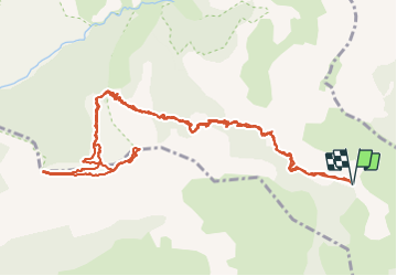
Ruta Senderismo de 15,2 km a descubrir en Provenza-Alpes-Costa Azul, Altos Alpes, Gap. Esta ruta ha sido propuesta por PapouBertrand.
Descripción
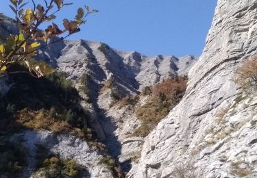
Jolie Rando avec de très beaux paysages. L'itinéraire est très peu visible entre le Roc de la petite Melette et le Pic des ruines de la Luvie. Il faut se frayer une chemin dans une basse végétation qui recouvre le sentier.
Localización
País:
France
Región :
Provenza-Alpes-Costa Azul
Departamento/provincia :
Altos Alpes
Municipio :
Gap
Localidad:
Gap
Salida:(Dec)
Salida:(UTM)
265829 ; 4945246 (32T) N.
Comentarios
Excursiones cerca
![Excursión Senderismo Gap - Brèche et croix de Charance - Photo](https://media.geolcdn.com/t/375/260/ext.jpg?maxdim=2&url=https%3A%2F%2Fservices.sitytrail.com%2FGeolivesWS%2FDownloadMedia.ashx%3FTrailID%3D95802%26Media%3D20111201151419.jpg)
![Senderismo Senderismo](https://static1.geolcdn.com/sitytour/trail-icons/101.png)
Brèche et croix de Charance
Senderismo
Fácil
(1)
Gap,
Provenza-Alpes-Costa Azul,
Altos Alpes,
France
![](/images/other/stat-length.png)
8,6 km | 18,5 km-effort
2h 13min
![](https://static1.geolcdn.com/siteimages/upload/files/16400158638029165_repeat_loop_refresh_sync_direction_icon.png)
No
![Excursión Senderismo Rabou - Rabou Tour du Puy - Photo](https://media.geolcdn.com/t/375/260/805e1ce0-378d-4868-bdbb-2f6f352f7b11.jpg&format=jpg&maxdim=2)
![Senderismo Senderismo](https://static1.geolcdn.com/sitytour/trail-icons/101.png)
Rabou Tour du Puy
Senderismo
Medio
Rabou,
Provenza-Alpes-Costa Azul,
Altos Alpes,
France
![](/images/other/stat-length.png)
11,5 km | 21 km-effort
4h 46min
![](https://static1.geolcdn.com/siteimages/upload/files/16400158638029165_repeat_loop_refresh_sync_direction_icon.png)
Sí
![Excursión Senderismo Gap - Pic de Charance - Photo](https://media.geolcdn.com/t/375/260/1b819787-5cbc-4e39-b2ee-7b1b220b0af8.jpg&format=jpg&maxdim=2)
![Senderismo Senderismo](https://static1.geolcdn.com/sitytour/trail-icons/101.png)
Pic de Charance
Senderismo
Medio
Gap,
Provenza-Alpes-Costa Azul,
Altos Alpes,
France
![](/images/other/stat-length.png)
8,9 km | 19 km-effort
4h 18min
![](https://static1.geolcdn.com/siteimages/upload/files/16400158638029165_repeat_loop_refresh_sync_direction_icon.png)
Sí
![Excursión Senderismo Rabou - Pic Melette - Photo](https://media.geolcdn.com/t/375/260/4622a0c3-66f1-414b-9c6c-2d569eb751b3.jpg&format=jpg&maxdim=2)
![Senderismo Senderismo](https://static1.geolcdn.com/sitytour/trail-icons/101.png)
Pic Melette
Senderismo
Difícil
Rabou,
Provenza-Alpes-Costa Azul,
Altos Alpes,
France
![](/images/other/stat-length.png)
9,8 km | 22 km-effort
4h 59min
![](https://static1.geolcdn.com/siteimages/upload/files/16400158638029165_repeat_loop_refresh_sync_direction_icon.png)
Sí
![Excursión Senderismo Gap - Pic de Gleize - Photo](https://media.geolcdn.com/t/375/260/9b3dcddd-15e9-4793-a987-aa74cd6c203d.jpg&format=jpg&maxdim=2)
![Senderismo Senderismo](https://static1.geolcdn.com/sitytour/trail-icons/101.png)
Pic de Gleize
Senderismo
Medio
Gap,
Provenza-Alpes-Costa Azul,
Altos Alpes,
France
![](/images/other/stat-length.png)
4,8 km | 10,6 km-effort
2h 25min
![](https://static1.geolcdn.com/siteimages/upload/files/16400158638029165_repeat_loop_refresh_sync_direction_icon.png)
Sí
![Excursión Senderismo Gap - Cuchon-Pic de Charance - Photo](https://media.geolcdn.com/t/375/260/273370c5-f091-46d0-92ed-fb2a447f25db.jpg&format=jpg&maxdim=2)
![Senderismo Senderismo](https://static1.geolcdn.com/sitytour/trail-icons/101.png)
Cuchon-Pic de Charance
Senderismo
Difícil
Gap,
Provenza-Alpes-Costa Azul,
Altos Alpes,
France
![](/images/other/stat-length.png)
12,3 km | 24 km-effort
5h 32min
![](https://static1.geolcdn.com/siteimages/upload/files/16400158638029165_repeat_loop_refresh_sync_direction_icon.png)
Sí
![Excursión Senderismo Gap - Col de Guizière - Photo](https://media.geolcdn.com/t/375/260/48c56f83-5df5-469d-a27d-85eb85489bb3.jpg&format=jpg&maxdim=2)
![Senderismo Senderismo](https://static1.geolcdn.com/sitytour/trail-icons/101.png)
Col de Guizière
Senderismo
Medio
Gap,
Provenza-Alpes-Costa Azul,
Altos Alpes,
France
![](/images/other/stat-length.png)
8,7 km | 17,5 km-effort
3h 58min
![](https://static1.geolcdn.com/siteimages/upload/files/16400158638029165_repeat_loop_refresh_sync_direction_icon.png)
Sí
![Excursión A pie Rabou - 9587041 - Photo](https://media.geolcdn.com/t/375/260/6a1636b4-b223-413d-a187-700130d298fe.jpg&format=jpg&maxdim=2)
![A pie A pie](https://static1.geolcdn.com/sitytour/trail-icons/100.png)
9587041
A pie
Fácil
Rabou,
Provenza-Alpes-Costa Azul,
Altos Alpes,
France
![](/images/other/stat-length.png)
6,6 km | 10,6 km-effort
3h 56min
![](https://static1.geolcdn.com/siteimages/upload/files/16400158638029165_repeat_loop_refresh_sync_direction_icon.png)
No
![Excursión Senderismo La Fare-en-Champsaur - Le Girolet - Photo](https://media.geolcdn.com/t/375/260/db985afe-8ded-41a5-8002-487c3b42ed04.jpg&format=jpg&maxdim=2)
![Senderismo Senderismo](https://static1.geolcdn.com/sitytour/trail-icons/101.png)
Le Girolet
Senderismo
Medio
La Fare-en-Champsaur,
Provenza-Alpes-Costa Azul,
Altos Alpes,
France
![](/images/other/stat-length.png)
11,6 km | 24 km-effort
4h 45min
![](https://static1.geolcdn.com/siteimages/upload/files/16400158638029165_repeat_loop_refresh_sync_direction_icon.png)
Sí
Magnifiques photos. Merci !