![](/images/other/stat-length.png)
![Excursión Senderismo Presles - Serre Cocu - Photo](https://media.geolcdn.com/t/1900/400/c6ae6590-00d5-48b0-b0f3-2db735c94974.jpg&format=pjpeg&maxdim=2)
Serre Cocu
crocau
Usuario
![Longitud](/images/other/stat-length.png)
Longitud
4,7 km
![Altitud máxima](https://static1.geolcdn.com/siteimages/upload/files/1508320355ic_sort_altitude_max_24dp.png)
Altitud máxima
1002 m
![Desnivel positivo](https://static1.geolcdn.com/siteimages/upload/files/1508320355ic_sort_den_pos_24dp.png)
Desnivel positivo
170 m
![Km-Effort](/images/other/stat-length.png)
Km-Effort
6,9 km
![Altitud mínima](https://static1.geolcdn.com/siteimages/upload/files/1508320355ic_sort_altitude_min_24dp.png)
Altitud mínima
846 m
![Desnivel negativo](https://static1.geolcdn.com/siteimages/upload/files/1508320355ic_sort_den_neg_24dp.png)
Desnivel negativo
173 m
![Boucle](https://static1.geolcdn.com/siteimages/upload/files/16400158638029165_repeat_loop_refresh_sync_direction_icon.png)
Boucle
Sí
Fecha de creación :
2021-10-02 13:53:15.372
Última modificación :
2021-10-02 17:06:05.563
![Senderismo](https://static1.geolcdn.com/sitytour/trail-icons/101.png)
2h11
Dificultad : Muy fácil
![Escanee este código QR para abrir la excursión en la aplicación SityTrail](https://capi.geolives.com/qq0zvz2zws4bq2lad0pu/sitytour/trails/2956818/qr.png?size=200)
Aplicación GPS de excursión GRATIS
A propósito
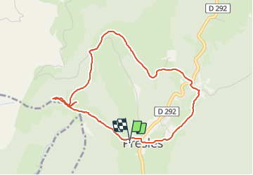
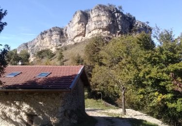
Ruta Senderismo de 4,7 km a descubrir en Auvergne-Rhône-Alpes, Isère, Presles. Esta ruta ha sido propuesta por crocau.
Descripción
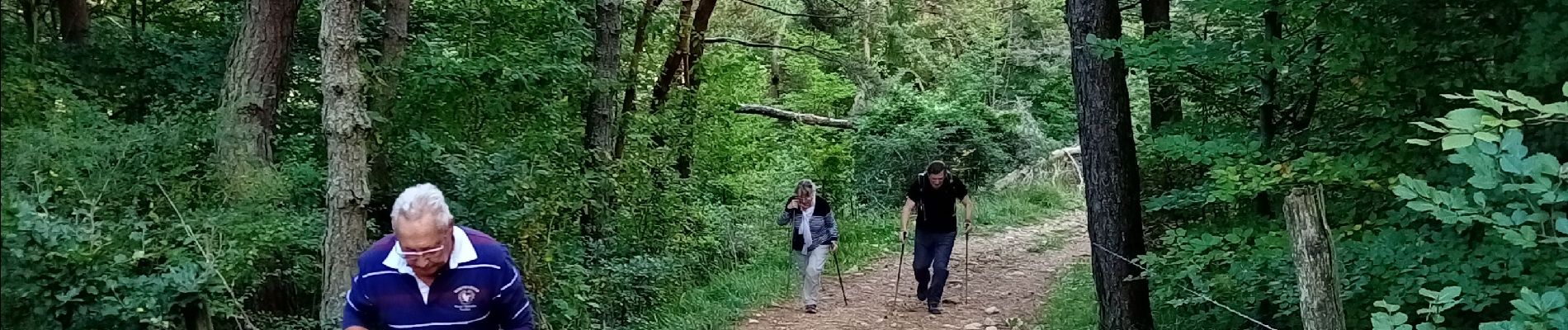
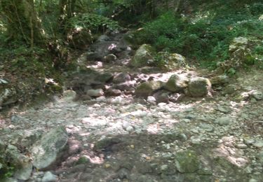
Une légère bavante puis une balade agréable et douce..Théoriquement se fait en 1h20 mais là on a traîné avec les seniors .
Localización
País:
France
Región :
Auvergne-Rhône-Alpes
Departamento/provincia :
Isère
Municipio :
Presles
Localidad:
Unknown
Salida:(Dec)
Salida:(UTM)
687364 ; 4995856 (31T) N.
Comentarios
Excursiones cerca
![Excursión Senderismo Châtelus - 38 bournillon porte du diable charmatte - Photo](https://media.geolcdn.com/t/375/260/d74c1d26-f2c4-4c87-8563-94950cba2a2c.jpg&format=jpg&maxdim=2)
![Senderismo Senderismo](https://static1.geolcdn.com/sitytour/trail-icons/101.png)
38 bournillon porte du diable charmatte
Senderismo
Difícil
(1)
Châtelus,
Auvergne-Rhône-Alpes,
Isère,
France
![](/images/other/stat-length.png)
16,5 km | 34 km-effort
8h 7min
![](https://static1.geolcdn.com/siteimages/upload/files/16400158638029165_repeat_loop_refresh_sync_direction_icon.png)
Sí
![Excursión Senderismo Châtelus - Boucle Pas de l'Allier - Pas des Voutes - Photo](https://media.geolcdn.com/t/375/260/ext.jpg?maxdim=2&url=https%3A%2F%2Fservices.sitytrail.com%2FGeolivesWS%2FDownloadMedia.ashx%3FTrailID%3D105085%26Media%3D8675_1.jpg)
![Senderismo Senderismo](https://static1.geolcdn.com/sitytour/trail-icons/101.png)
Boucle Pas de l'Allier - Pas des Voutes
Senderismo
Medio
(1)
Châtelus,
Auvergne-Rhône-Alpes,
Isère,
France
![](/images/other/stat-length.png)
10,1 km | 22 km-effort
4h 30min
![](https://static1.geolcdn.com/siteimages/upload/files/16400158638029165_repeat_loop_refresh_sync_direction_icon.png)
Sí
![Excursión Senderismo Sainte-Eulalie-en-Royans - 26 ste eulalie - Photo](https://media.geolcdn.com/t/375/260/cc17d7c1-039b-4811-aa20-433bfbe37107.jpg&format=jpg&maxdim=2)
![Senderismo Senderismo](https://static1.geolcdn.com/sitytour/trail-icons/101.png)
26 ste eulalie
Senderismo
Medio
Sainte-Eulalie-en-Royans,
Auvergne-Rhône-Alpes,
Drôme,
France
![](/images/other/stat-length.png)
14,8 km | 27 km-effort
6h 43min
![](https://static1.geolcdn.com/siteimages/upload/files/16400158638029165_repeat_loop_refresh_sync_direction_icon.png)
No
![Excursión Senderismo Châtelus - 38 pabro charmatte - Photo](https://media.geolcdn.com/t/375/260/983fca8d-ac95-4180-878f-eb8932bd4279.jpg&format=jpg&maxdim=2)
![Senderismo Senderismo](https://static1.geolcdn.com/sitytour/trail-icons/101.png)
38 pabro charmatte
Senderismo
Difícil
Châtelus,
Auvergne-Rhône-Alpes,
Isère,
France
![](/images/other/stat-length.png)
11,4 km | 29 km-effort
7h 43min
![](https://static1.geolcdn.com/siteimages/upload/files/16400158638029165_repeat_loop_refresh_sync_direction_icon.png)
Sí
![Excursión Senderismo Pont-en-Royans - 38 pont en Royans choranche presles - Photo](https://media.geolcdn.com/t/375/260/55a7031b-27da-4fe2-88f7-a5894b7e1ffc.jpg&format=jpg&maxdim=2)
![Senderismo Senderismo](https://static1.geolcdn.com/sitytour/trail-icons/101.png)
38 pont en Royans choranche presles
Senderismo
Difícil
Pont-en-Royans,
Auvergne-Rhône-Alpes,
Isère,
France
![](/images/other/stat-length.png)
15,4 km | 30 km-effort
6h 52min
![](https://static1.geolcdn.com/siteimages/upload/files/16400158638029165_repeat_loop_refresh_sync_direction_icon.png)
Sí
![Excursión Senderismo Saint-Pierre-de-Chérennes - 38 st pierre de cherennes faz - Photo](https://media.geolcdn.com/t/375/260/0a570fe9-a063-4011-b0d0-8b0ccdb349b0.jpg&format=jpg&maxdim=2)
![Senderismo Senderismo](https://static1.geolcdn.com/sitytour/trail-icons/101.png)
38 st pierre de cherennes faz
Senderismo
Medio
Saint-Pierre-de-Chérennes,
Auvergne-Rhône-Alpes,
Isère,
France
![](/images/other/stat-length.png)
17,5 km | 32 km-effort
7h 27min
![](https://static1.geolcdn.com/siteimages/upload/files/16400158638029165_repeat_loop_refresh_sync_direction_icon.png)
Sí
![Excursión Senderismo Pont-en-Royans - 38 pont en Royans st andre - Photo](https://media.geolcdn.com/t/375/260/9999e3ad-9f99-41dc-bf89-768d521527c3.jpg&format=jpg&maxdim=2)
![Senderismo Senderismo](https://static1.geolcdn.com/sitytour/trail-icons/101.png)
38 pont en Royans st andre
Senderismo
Fácil
Pont-en-Royans,
Auvergne-Rhône-Alpes,
Isère,
France
![](/images/other/stat-length.png)
14,1 km | 19,3 km-effort
3h 33min
![](https://static1.geolcdn.com/siteimages/upload/files/16400158638029165_repeat_loop_refresh_sync_direction_icon.png)
Sí
![Excursión Carrera Beauvoir-en-Royans - Serre Cocu de Beauvoir - Photo](https://media.geolcdn.com/t/375/260/09522623-4bb9-4c1b-9a88-4308da1f7826.jpg&format=jpg&maxdim=2)
![Carrera Carrera](https://static1.geolcdn.com/sitytour/trail-icons/103.png)
Serre Cocu de Beauvoir
Carrera
Medio
Beauvoir-en-Royans,
Auvergne-Rhône-Alpes,
Isère,
France
![](/images/other/stat-length.png)
14,1 km | 24 km-effort
2h 19min
![](https://static1.geolcdn.com/siteimages/upload/files/16400158638029165_repeat_loop_refresh_sync_direction_icon.png)
Sí
![Excursión Senderismo Pont-en-Royans - 38 pont en Royans serre cocu - Photo](https://media.geolcdn.com/t/375/260/72853ffa-a2a8-4453-a880-6a63c61d611f.jpg&format=jpg&maxdim=2)
![Senderismo Senderismo](https://static1.geolcdn.com/sitytour/trail-icons/101.png)
38 pont en Royans serre cocu
Senderismo
Medio
Pont-en-Royans,
Auvergne-Rhône-Alpes,
Isère,
France
![](/images/other/stat-length.png)
16 km | 29 km-effort
7h 44min
![](https://static1.geolcdn.com/siteimages/upload/files/16400158638029165_repeat_loop_refresh_sync_direction_icon.png)
Sí