![](/images/other/stat-length.png)
![Excursión Senderismo Saint-Amand-Montrond - Compostelle etape 9 et 10 - Photo](https://media.geolcdn.com/t/1900/400/ext.pjpeg?maxdim=2&url=https%3A%2F%2Fstatic1.geolcdn.com%2Fsiteimages%2Fupload%2Ffiles%2F1553511878bg_sport_marche.png)
Compostelle etape 9 et 10
maginot
Usuario
![Longitud](/images/other/stat-length.png)
Longitud
63 km
![Altitud máxima](https://static1.geolcdn.com/siteimages/upload/files/1508320355ic_sort_altitude_max_24dp.png)
Altitud máxima
289 m
![Desnivel positivo](https://static1.geolcdn.com/siteimages/upload/files/1508320355ic_sort_den_pos_24dp.png)
Desnivel positivo
651 m
![Km-Effort](/images/other/stat-length.png)
Km-Effort
72 km
![Altitud mínima](https://static1.geolcdn.com/siteimages/upload/files/1508320355ic_sort_altitude_min_24dp.png)
Altitud mínima
149 m
![Desnivel negativo](https://static1.geolcdn.com/siteimages/upload/files/1508320355ic_sort_den_neg_24dp.png)
Desnivel negativo
598 m
![Boucle](https://static1.geolcdn.com/siteimages/upload/files/16400158638029165_repeat_loop_refresh_sync_direction_icon.png)
Boucle
No
Fecha de creación :
2021-09-28 07:16:41.0
Última modificación :
2021-09-29 19:36:43.091
![Senderismo](https://static1.geolcdn.com/sitytour/trail-icons/101.png)
16h19
Dificultad : Medio
![Escanee este código QR para abrir la excursión en la aplicación SityTrail](https://capi.geolives.com/qq0zvz2zws4bq2lad0pu/sitytour/trails/2953975/qr.png?size=200)
Aplicación GPS de excursión GRATIS
A propósito
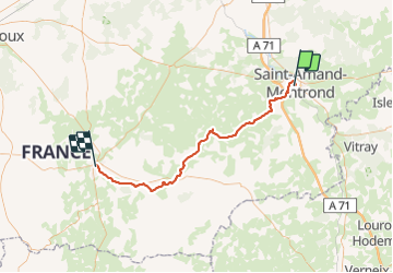
Ruta Senderismo de 63 km a descubrir en Centro, Cher, Saint-Amand-Montrond. Esta ruta ha sido propuesta por maginot.
Descripción
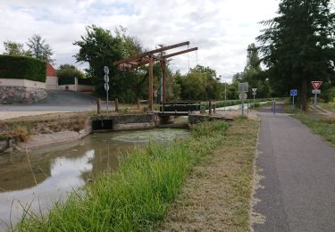
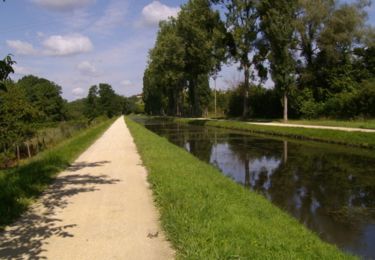
Etape 9 quelques beau chemin surtout en fin d etape
Etape 10 surtout des petites routes
Localización
País:
France
Región :
Centro
Departamento/provincia :
Cher
Municipio :
Saint-Amand-Montrond
Localidad:
Unknown
Salida:(Dec)
Salida:(UTM)
460975 ; 5173948 (31T) N.
Comentarios
Excursiones cerca
![Excursión Bicicleta híbrida Orval - saint amand montrond vallon - Photo](https://media.geolcdn.com/t/375/260/5cf692ca-e49d-4db0-8b2d-3b5da493aa1d.jpg&format=jpg&maxdim=2)
![Bicicleta híbrida Bicicleta híbrida](https://static1.geolcdn.com/sitytour/trail-icons/203.png)
saint amand montrond vallon
Bicicleta híbrida
Muy fácil
Orval,
Centro,
Cher,
France
![](/images/other/stat-length.png)
28 km | 31 km-effort
1h 27min
![](https://static1.geolcdn.com/siteimages/upload/files/16400158638029165_repeat_loop_refresh_sync_direction_icon.png)
No
![Excursión Senderismo Saint-Amand-Montrond - Remise en forme le long du Canal de Berry - Saint Amand Montrond - Photo](https://media.geolcdn.com/t/375/260/ext.jpg?maxdim=2&url=https%3A%2F%2Fservices.sitytrail.com%2FGeolivesWS%2FDownloadMedia.ashx%3FTrailID%3D105789%26Media%3D9693_1.jpg)
![Senderismo Senderismo](https://static1.geolcdn.com/sitytour/trail-icons/101.png)
Remise en forme le long du Canal de Berry - Saint Amand Montrond
Senderismo
Medio
Saint-Amand-Montrond,
Centro,
Cher,
France
![](/images/other/stat-length.png)
12,4 km | 13,2 km-effort
2h 10min
![](https://static1.geolcdn.com/siteimages/upload/files/16400158638029165_repeat_loop_refresh_sync_direction_icon.png)
Sí
![Excursión Bici de montaña Saint-Amand-Montrond - Tour du lac de Virlay - Photo](https://media.geolcdn.com/t/375/260/ext.jpg?maxdim=2&url=https%3A%2F%2Fstatic1.geolcdn.com%2Fsiteimages%2Fupload%2Ffiles%2F1524743154velo.jpg)
![Bici de montaña Bici de montaña](https://static1.geolcdn.com/sitytour/trail-icons/202.png)
Tour du lac de Virlay
Bici de montaña
Muy fácil
Saint-Amand-Montrond,
Centro,
Cher,
France
![](/images/other/stat-length.png)
5,9 km | 6,2 km-effort
33min
![](https://static1.geolcdn.com/siteimages/upload/files/16400158638029165_repeat_loop_refresh_sync_direction_icon.png)
Sí
![Excursión Senderismo Drevant - drevant - Photo](https://media.geolcdn.com/t/375/260/ext.jpg?maxdim=2&url=https%3A%2F%2Fstatic1.geolcdn.com%2Fsiteimages%2Fupload%2Ffiles%2F1553511878bg_sport_marche.png)
![Senderismo Senderismo](https://static1.geolcdn.com/sitytour/trail-icons/101.png)
![Excursión Senderismo Saint-Amand-Montrond - canal du Berry - Photo](https://media.geolcdn.com/t/375/260/ext.jpg?maxdim=2&url=https%3A%2F%2Fstatic1.geolcdn.com%2Fsiteimages%2Fupload%2Ffiles%2F1553511878bg_sport_marche.png)
![Senderismo Senderismo](https://static1.geolcdn.com/sitytour/trail-icons/101.png)
canal du Berry
Senderismo
Muy fácil
Saint-Amand-Montrond,
Centro,
Cher,
France
![](/images/other/stat-length.png)
7,7 km | 8,1 km-effort
1h 58min
![](https://static1.geolcdn.com/siteimages/upload/files/16400158638029165_repeat_loop_refresh_sync_direction_icon.png)
Sí
![Excursión Bicicleta híbrida Saint-Amand-Montrond - le Veurdre - Photo](https://media.geolcdn.com/t/375/260/ext.jpg?maxdim=2&url=https%3A%2F%2Fstatic1.geolcdn.com%2Fsiteimages%2Fupload%2Ffiles%2F1524743154velo.jpg)
![Bicicleta híbrida Bicicleta híbrida](https://static1.geolcdn.com/sitytour/trail-icons/203.png)
le Veurdre
Bicicleta híbrida
Muy fácil
Saint-Amand-Montrond,
Centro,
Cher,
France
![](/images/other/stat-length.png)
61 km | 66 km-effort
4h 16min
![](https://static1.geolcdn.com/siteimages/upload/files/16400158638029165_repeat_loop_refresh_sync_direction_icon.png)
No
![Excursión Bici de montaña Saint-Amand-Montrond - 3 Saint Amand Montrond-Neuvy-St Jacques de Compostelle - Photo](https://media.geolcdn.com/t/375/260/ext.jpg?maxdim=2&url=https%3A%2F%2Fstatic1.geolcdn.com%2Fsiteimages%2Fupload%2Ffiles%2F1524743154velo.jpg)
![Bici de montaña Bici de montaña](https://static1.geolcdn.com/sitytour/trail-icons/202.png)
3 Saint Amand Montrond-Neuvy-St Jacques de Compostelle
Bici de montaña
Difícil
Saint-Amand-Montrond,
Centro,
Cher,
France
![](/images/other/stat-length.png)
107 km | 123 km-effort
8h 1min
![](https://static1.geolcdn.com/siteimages/upload/files/16400158638029165_repeat_loop_refresh_sync_direction_icon.png)
No
![Excursión Senderismo Saint-Amand-Montrond - la Tranchasse - Photo](https://media.geolcdn.com/t/375/260/ext.jpg?maxdim=2&url=https%3A%2F%2Fstatic1.geolcdn.com%2Fsiteimages%2Fupload%2Ffiles%2F1553511878bg_sport_marche.png)
![Senderismo Senderismo](https://static1.geolcdn.com/sitytour/trail-icons/101.png)
la Tranchasse
Senderismo
Muy fácil
Saint-Amand-Montrond,
Centro,
Cher,
France
![](/images/other/stat-length.png)
31 km | 34 km-effort
Desconocido
![](https://static1.geolcdn.com/siteimages/upload/files/16400158638029165_repeat_loop_refresh_sync_direction_icon.png)
Sí
![Excursión Senderismo Saint-Georges-de-Poisieux - Les Sources - Photo](https://media.geolcdn.com/t/375/260/ext.jpg?maxdim=2&url=https%3A%2F%2Fstatic1.geolcdn.com%2Fsiteimages%2Fupload%2Ffiles%2F1553511878bg_sport_marche.png)
![Senderismo Senderismo](https://static1.geolcdn.com/sitytour/trail-icons/101.png)
Les Sources
Senderismo
Difícil
Saint-Georges-de-Poisieux,
Centro,
Cher,
France
![](/images/other/stat-length.png)
13,8 km | 16,1 km-effort
3h 39min
![](https://static1.geolcdn.com/siteimages/upload/files/16400158638029165_repeat_loop_refresh_sync_direction_icon.png)
Sí