![](/images/other/stat-length.png)
![Excursión Senderismo Raismes - variante de la course des terrils - Photo](https://media.geolcdn.com/t/1900/400/f1af6116-6469-445b-a358-4f5a4f22ced7.jpg&format=pjpeg&maxdim=2)
variante de la course des terrils
papiou
Usuario
![Longitud](/images/other/stat-length.png)
![Altitud máxima](https://static1.geolcdn.com/siteimages/upload/files/1508320355ic_sort_altitude_max_24dp.png)
![Desnivel positivo](https://static1.geolcdn.com/siteimages/upload/files/1508320355ic_sort_den_pos_24dp.png)
![Km-Effort](/images/other/stat-length.png)
![Altitud mínima](https://static1.geolcdn.com/siteimages/upload/files/1508320355ic_sort_altitude_min_24dp.png)
![Desnivel negativo](https://static1.geolcdn.com/siteimages/upload/files/1508320355ic_sort_den_neg_24dp.png)
![Boucle](https://static1.geolcdn.com/siteimages/upload/files/16400158638029165_repeat_loop_refresh_sync_direction_icon.png)
![Senderismo](https://static1.geolcdn.com/sitytour/trail-icons/101.png)
2h10
Dificultad : Medio
![Escanee este código QR para abrir la excursión en la aplicación SityTrail](https://capi.geolives.com/qq0zvz2zws4bq2lad0pu/sitytour/trails/2952633/qr.png?size=200)
Aplicación GPS de excursión GRATIS
A propósito
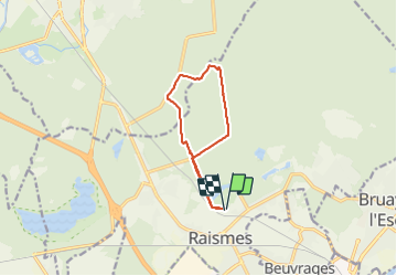
Ruta Senderismo de 8,8 km a descubrir en Alta Francia, Norte, Raismes. Esta ruta ha sido propuesta por papiou.
Descripción
départ château princesse et partir vers cimetière vicoigne puis par dreve de vicoigne rejoindre celle de raismes pour par la gauche aller jusqu'à BB rose. là prendre petit sentier plein de méandres pour rejoindre sentier allée des hêtres vers dreve des insurgés puis à gauche rejoindre une fourche et partir à droite pour rejoindre cimetière en passant par petit terril et revenir au départ
Localización
Comentarios
Excursiones cerca
![Excursión Senderismo Raismes - Circuit du Terril de Sabatier - Photo](https://media.geolcdn.com/t/375/260/ext.jpg?maxdim=2&url=https%3A%2F%2Fservices.sitytrail.com%2FGeolivesWS%2FDownloadMedia.ashx%3FTrailID%3D479716%26Media%3D781031eb-7ab3-4c80-8a0c-0836d5a81ce2.JPG)
![Senderismo Senderismo](https://static1.geolcdn.com/sitytour/trail-icons/101.png)
Senderismo
![](/images/other/stat-length.png)
![](https://static1.geolcdn.com/siteimages/upload/files/16400158638029165_repeat_loop_refresh_sync_direction_icon.png)
![Excursión Senderismo Wallers - Mare à Goriau - Photo](https://media.geolcdn.com/t/375/260/299e6191-18b5-438f-9d95-49f66a90f690.jpg&format=jpg&maxdim=2)
![Senderismo Senderismo](https://static1.geolcdn.com/sitytour/trail-icons/101.png)
Senderismo
![](/images/other/stat-length.png)
![](https://static1.geolcdn.com/siteimages/upload/files/16400158638029165_repeat_loop_refresh_sync_direction_icon.png)
![Excursión Senderismo Raismes - Mare à Goriaux - Photo](https://media.geolcdn.com/t/375/260/cb4184f6-3666-47fb-a89a-0644abab2b32.jpg&format=jpg&maxdim=2)
![Senderismo Senderismo](https://static1.geolcdn.com/sitytour/trail-icons/101.png)
Senderismo
![](/images/other/stat-length.png)
![](https://static1.geolcdn.com/siteimages/upload/files/16400158638029165_repeat_loop_refresh_sync_direction_icon.png)
![Excursión Senderismo Raismes - Terril du lavoir Rousseau - Photo](https://media.geolcdn.com/t/375/260/55636772-211b-4a0e-95d1-d18ad30169e0.jpg&format=jpg&maxdim=2)
![Senderismo Senderismo](https://static1.geolcdn.com/sitytour/trail-icons/101.png)
Senderismo
![](/images/other/stat-length.png)
![](https://static1.geolcdn.com/siteimages/upload/files/16400158638029165_repeat_loop_refresh_sync_direction_icon.png)
![Excursión Senderismo Saint-Amand-les-Eaux - terril vicoigne - Photo](https://media.geolcdn.com/t/375/260/d8552856-5959-4bc8-a6d2-93f721ca17ec.jpg&format=jpg&maxdim=2)
![Senderismo Senderismo](https://static1.geolcdn.com/sitytour/trail-icons/101.png)
Senderismo
![](/images/other/stat-length.png)
![](https://static1.geolcdn.com/siteimages/upload/files/16400158638029165_repeat_loop_refresh_sync_direction_icon.png)
![Excursión Senderismo Raismes - terril du lavoir rousseau - Photo](https://media.geolcdn.com/t/375/260/2a750bf1-1f0f-4ec6-9f4d-4d916d2a14af.jpg&format=jpg&maxdim=2)
![Senderismo Senderismo](https://static1.geolcdn.com/sitytour/trail-icons/101.png)
Senderismo
![](/images/other/stat-length.png)
![](https://static1.geolcdn.com/siteimages/upload/files/16400158638029165_repeat_loop_refresh_sync_direction_icon.png)
![Excursión Senderismo Saint-Amand-les-Eaux - notre dame d'amour(NDA), propose par VDN - Photo](https://media.geolcdn.com/t/375/260/630cd120-0ef0-4a83-86e7-91e6331d9f35.jpg&format=jpg&maxdim=2)
![Senderismo Senderismo](https://static1.geolcdn.com/sitytour/trail-icons/101.png)
Senderismo
![](/images/other/stat-length.png)
![](https://static1.geolcdn.com/siteimages/upload/files/16400158638029165_repeat_loop_refresh_sync_direction_icon.png)
![Excursión Senderismo Wallers - Mare goraux - Photo](https://media.geolcdn.com/t/375/260/82eaa7c8-ae6a-4094-92a3-48d31e49731d.jpg&format=jpg&maxdim=2)
![Senderismo Senderismo](https://static1.geolcdn.com/sitytour/trail-icons/101.png)
Senderismo
![](/images/other/stat-length.png)
![](https://static1.geolcdn.com/siteimages/upload/files/16400158638029165_repeat_loop_refresh_sync_direction_icon.png)
![Excursión Senderismo Saint-Amand-les-Eaux - Mesnil, version plus longue - Photo](https://media.geolcdn.com/t/375/260/e5ac201c-8480-46b8-81d2-a49e027ccf3b.jpg&format=jpg&maxdim=2)
![Senderismo Senderismo](https://static1.geolcdn.com/sitytour/trail-icons/101.png)
Senderismo
![](/images/other/stat-length.png)
![](https://static1.geolcdn.com/siteimages/upload/files/16400158638029165_repeat_loop_refresh_sync_direction_icon.png)